File:Circum-Arctic Map of Permafrost and Ground Ice Conditions.png
本预览的尺寸:534 × 599像素。 其他分辨率:214 × 240像素 | 428 × 480像素 | 683 × 766像素。
原始文件 (683 × 766像素,文件大小:29 KB,MIME类型:image/png)

|
此map图片可使用矢量图形重新创建为SVG文件。这具有很多好处;更多信息请参见共享资源:待清理媒体。如果存在此图片的SVG格式,请将其上传,然后将此模板替换为
{{vector version available|新图片名称}}。
建议您将SVG命名为“Circum-Arctic Map of Permafrost and Ground Ice Conditions.svg”,这样在使用Vector version available(或Vva)模板时就不需要填写新图片名称参数。 |
摘要
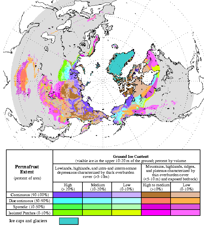
| 描述 | Circum-Arctic Map of Permafrost and Ground Ice Conditions |
| 日期 | 1998, revised February 2001 |
| 来源 | http://nsidc.org/data/docs/fgdc/ggd318_map_circumarctic/index.html |
| 作者 | Brown, J., O.J. Ferrians, Jr., J.A. Heginbottom, and E.S. Melnikov. 1998, revised February 2001. Circum-arctic map of permafrost and ground ice conditions. Boulder, CO: National Snow and Ice Data Center/World Data Center for Glaciology |
许可协议
此作品在美国属于公有领域,因为其是由美国政府的官员或雇员,基于其个人公务目的制作的作品,参考美国法典第17篇第1章第105条。
注意︰本模板仅适用于美国联邦政府的原创作品,不适用于任何美国州、属地、联邦个体、县、市或任何次级政府的作品。本模板也不适用于1978年以后由美国邮政署出版的邮票图案(参看美国版权局实践纲领第313.6(C)(1)条)。也不适用于部分美国硬币;参看美国铸币局使用条款。 |
 | |
| 本文件已被确认为免除已知的著作权法限制(包括所有相关权利)。 | ||
文件历史
点击某个日期/时间查看对应时刻的文件。
| 日期/时间 | 缩略图 | 大小 | 用户 | 备注 | |
|---|---|---|---|---|---|
| 当前 | 2015年3月23日 (一) 13:21 | | 683 × 766(29 KB) | RokerHRO | optipng -o7 -i0 → 35.32% decrease |
| 2008年5月21日 (三) 18:40 |  | 683 × 766(44 KB) | Sagredo | {{Information |Description=Circum-Arctic Map of Permafrost and Ground Ice Conditions |Source=http://nsidc.org/data/docs/fgdc/ggd318_map_circumarctic/index.html |Date=1998, revised February 2001 |Author=Brown, J., O.J. Ferrians, Jr., J.A. Heginbottom, and |
文件用途
以下页面使用本文件:
全域文件用途
以下其他wiki使用此文件:
- bxr.wikipedia.org上的用途
- ca.wikipedia.org上的用途
- ckb.wikipedia.org上的用途
- cs.wikipedia.org上的用途
- de.wikipedia.org上的用途
- el.wikipedia.org上的用途
- en.wikipedia.org上的用途
- eo.wikipedia.org上的用途
- eu.wikipedia.org上的用途
- fa.wikipedia.org上的用途
- fr.wikipedia.org上的用途
- gl.wikipedia.org上的用途
- ha.wikipedia.org上的用途
- he.wikipedia.org上的用途
- ויקיפדיה:ערכים מומלצים/המלצות קודמות/פברואר 2017
- קפאת-עד
- תבנית:ערך מומלץ 19 בפברואר 2017
- תבנית:ערך מומלץ 20 בפברואר 2017
- פורטל:ערכים מומלצים/ערכים/קפאת-עד
- ויקיפדיה:ערכים מומלצים/המלצות קודמות/אפריל 2022
- ויקיפדיה:ערכים מומלצים/המלצות קודמות/פברואר 2024
- תבנית:ערך מומלץ 4 באפריל 2022
- תבנית:ערך מומלץ 14 בפברואר 2024
- hr.wikipedia.org上的用途
- id.wikipedia.org上的用途
- it.wikipedia.org上的用途
- ko.wikipedia.org上的用途
- ms.wikipedia.org上的用途
- ro.wikipedia.org上的用途
- ru.wikipedia.org上的用途
- simple.wikipedia.org上的用途
- si.wikipedia.org上的用途
- sl.wikipedia.org上的用途
- sv.wikipedia.org上的用途
- tr.wikipedia.org上的用途
- uk.wikipedia.org上的用途