File:Crossroads Baker Target Ship Map.png
此为最大尺寸。
Crossroads_Baker_Target_Ship_Map.png (500 × 500像素,文件大小:17 KB,MIME类型:image/png)

|
此military map图片可使用矢量图形重新创建为SVG文件。这具有很多好处;更多信息请参见共享资源:待清理媒体。如果存在此图片的SVG格式,请将其上传,然后将此模板替换为
{{vector version available|新图片名称}}。
建议您将SVG命名为“Crossroads Baker Target Ship Map.svg”,这样在使用Vector version available(或Vva)模板时就不需要填写新图片名称参数。 |
Image converted from .gif to .png with no changes.
摘要
| 描述 |
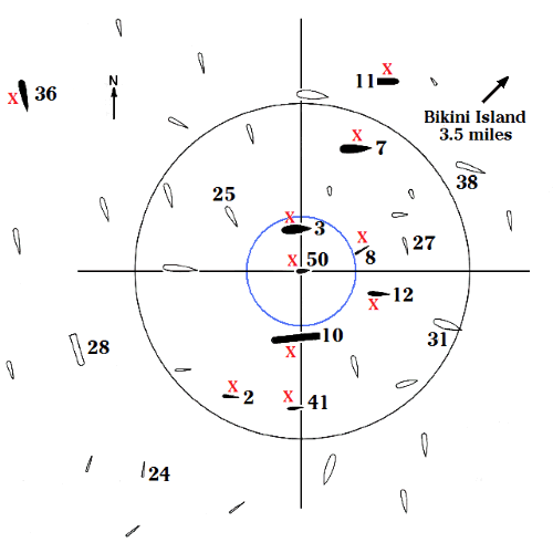
English: The array of target ships in Bikini lagoon for the Baker shot of Operation Crossroads, July, 25, 1946. The ten red X's mark the ten ships that sank. The black circle, with a radius of 1,000 yards from the point of detonation, outlines the area of serious ship damage. The blue circle, 330-yard radius, marks the rim of the shallow underwater crater created by the blast, as well as the circumference of the hollow water column which capsized the Arkansas. The submarines were submerged, the Pilotfish, ship #8, to a keel depth of 56 feet, and the Apogon, ship # 2, to a keel depth of 100 feet. |
| 日期 | |
| 来源 | Own work by uploader. Data in the map come from Delgado, James P., et al., The Archeology of the Atomic Bomb, National Park Service, Santa Fe, New Mexico, 1991. The Able map is on p 16, the Baker map on p 17, and ship damage and distances on pp 86-136. The full text of this reference is posted on the Internet.[1] |
| 作者 | HowardMorland |
许可协议
| 我,本作品著作权人,释出本作品至公有领域。这适用于全世界。 在一些国家这可能不合法;如果是这样的话,那么: 我无条件地授予任何人以任何目的使用本作品的权利,除非这些条件是法律规定所必需的。 |
文件历史
点击某个日期/时间查看对应时刻的文件。
| 日期/时间 | 缩略图 | 大小 | 用户 | 备注 | |
|---|---|---|---|---|---|
| 当前 | 2008年12月8日 (一) 02:58 | | 500 × 500(17 KB) | HowardMorland | Image converted from .gif to .png with no changes. <!--{{ImageUpload|basic}}--> |
文件用途
以下页面使用本文件:
全域文件用途
以下其他wiki使用此文件:
- de.wikipedia.org上的用途
- en.wikipedia.org上的用途
- es.wikipedia.org上的用途
- it.wikipedia.org上的用途
- pt.wikipedia.org上的用途
- ru.wikipedia.org上的用途
- tr.wikipedia.org上的用途
- uk.wikipedia.org上的用途