File:Crusade of 1101 v1.svg

此SVG文件的PNG预览的大小:800 × 559像素。 其他分辨率:320 × 224像素 | 640 × 447像素 | 1,024 × 716像素 | 1,280 × 894像素 | 2,560 × 1,789像素 | 1,039 × 726像素。
原始文件 (SVG文件,尺寸为1,039 × 726像素,文件大小:450 KB)
摘要
| 描述 |
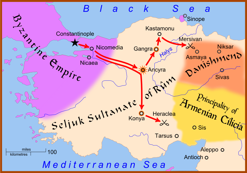
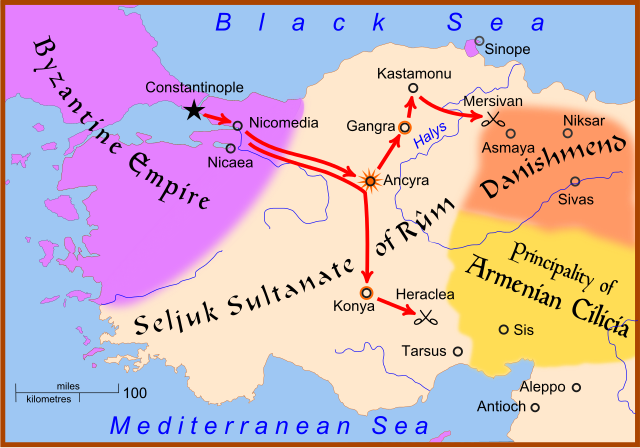
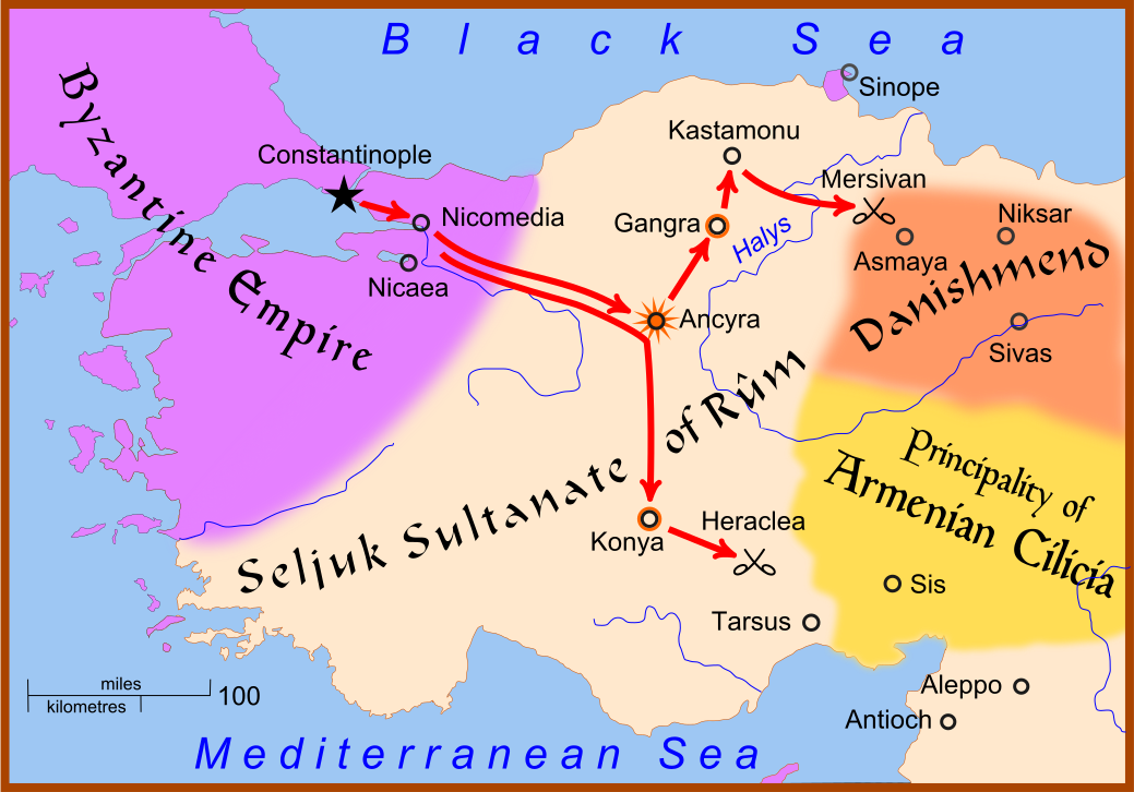
English: A map showing the movements of Christian armies in Anatolia during the Crusade of 1101.
The star at Ancyra indicates that the city was taken by the Crusaders. A circle around a city, as at Konya and Gangra, indicates that the city was placed under siege but was not taken. |
| 日期 | |
| 来源 | 基于如下对象的个人作品: Anatolia 1097.svg |
| 作者 | MapMaster |
| 其他版本 |
[]
|


References
- Hammond World Atlas Corporation (2007) Historical World Atlas, ISBN 9-780843-71391-6
- Fisher, Sydney Nettleton (2000年) 《 The Foreign Relations of Turkey 1481-1512》、Electronic Journal of Oriental Studies
- Runciman, Steven, A History of the Crusades, vol. 2: The Kingdom of Jerusalem and the Frankish East, 1100-1187, Cambridge University Press, 1951.
许可协议
我,本作品著作权人,特此采用以下许可协议发表本作品:

|
已授权您依据自由软件基金会发行的无固定段落及封面封底文字(Invariant Sections, Front-Cover Texts, and Back-Cover Texts)的GNU自由文件许可协议1.2版或任意后续版本的条款,复制、传播和/或修改本文件。该协议的副本请见“GNU Free Documentation License”。 |
This file is licensed under the Creative Commons Attribution-Share Alike 4.0 International, 3.0 Unported, 2.5 Generic, 2.0 Generic and 1.0 Generic license.
- 您可以自由地:
- 共享 – 复制、发行并传播本作品
- 修改 – 改编作品
- 惟须遵守下列条件:
- 署名 – 您必须对作品进行署名,提供授权条款的链接,并说明是否对原始内容进行了更改。您可以用任何合理的方式来署名,但不得以任何方式表明许可人认可您或您的使用。
- 相同方式共享 – 如果您再混合、转换或者基于本作品进行创作,您必须以与原先许可协议相同或相兼容的许可协议分发您贡献的作品。
您可以选择您需要的许可协议。
文件历史
点击某个日期/时间查看对应时刻的文件。
| 日期/时间 | 缩略图 | 大小 | 用户 | 备注 | |
|---|---|---|---|---|---|
| 当前 | 2008年2月28日 (四) 16:16 | | 1,039 × 726(450 KB) | MapMaster | Not Mervisan, but Mersivan |
| 2008年2月27日 (三) 22:04 |  | 1,039 × 726(457 KB) | MapMaster | {{Information |Description=A map showing the movements of Christian armies in Anatolia during the Crusade of 1101 |Source=self-made |Date=27 Feb 2008 |Author= MapMaster |Permission= |other_ver |
文件用途
以下2个页面使用本文件:
全域文件用途
以下其他wiki使用此文件:
- ast.wikipedia.org上的用途
- azb.wikipedia.org上的用途
- bg.wikipedia.org上的用途
- bn.wikipedia.org上的用途
- ca.wikipedia.org上的用途
- cs.wikipedia.org上的用途
- da.wikipedia.org上的用途
- de.wikipedia.org上的用途
- el.wikipedia.org上的用途
- en.wikipedia.org上的用途
- et.wikipedia.org上的用途
- eu.wikipedia.org上的用途
- fr.wikipedia.org上的用途
- hu.wikipedia.org上的用途
- id.wikipedia.org上的用途
- ja.wikipedia.org上的用途
- ko.wikipedia.org上的用途
- nl.wikipedia.org上的用途
- no.wikipedia.org上的用途
- pl.wikipedia.org上的用途
- ro.wikipedia.org上的用途
- ru.wikipedia.org上的用途
- sh.wikipedia.org上的用途
- sl.wikipedia.org上的用途
查看本文件的更多全域用途。