File:De facto cantons of Rojava.png

本预览的尺寸:725 × 599像素。 其他分辨率:290 × 240像素 | 581 × 480像素 | 929 × 768像素 | 1,239 × 1,024像素 | 2,000 × 1,653像素。
原始文件 (2,000 × 1,653像素,文件大小:268 KB,MIME类型:image/png)

|
此map图片可使用矢量图形重新创建为SVG文件。这具有很多好处;更多信息请参见共享资源:待清理媒体。如果存在此图片的SVG格式,请将其上传,然后将此模板替换为
{{vector version available|新图片名称}}。
建议您将SVG命名为“De facto cantons of Rojava.svg”,这样在使用Vector version available(或Vva)模板时就不需要填写新图片名称参数。 |
摘要
| 描述 |
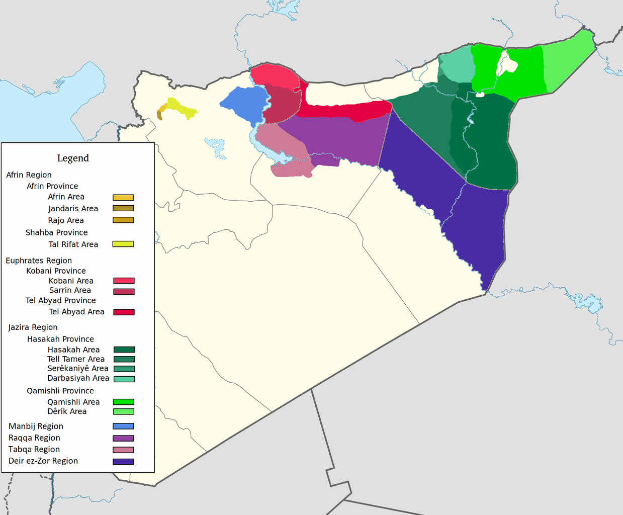
العربية: اقليم عفرين اقليم الفرات اقليم الجزيرة English: Afrin Region Euphrates Region Jazeera Region No region 한국어: 아프린 주 유프라테스 주 자제라 주 없음 |
| 日期 | |
| 来源 | 自己的作品 |
| 作者 | Editor abcdef |
| 其他版本 |
 |
许可协议
我,本作品著作权人,特此采用以下许可协议发表本作品:
本文件采用知识共享署名-相同方式共享 3.0 未本地化版本许可协议授权。
- 您可以自由地:
- 共享 – 复制、发行并传播本作品
- 修改 – 改编作品
- 惟须遵守下列条件:
- 署名 – 您必须对作品进行署名,提供授权条款的链接,并说明是否对原始内容进行了更改。您可以用任何合理的方式来署名,但不得以任何方式表明许可人认可您或您的使用。
- 相同方式共享 – 如果您再混合、转换或者基于本作品进行创作,您必须以与原先许可协议相同或相兼容的许可协议分发您贡献的作品。
文件历史
点击某个日期/时间查看对应时刻的文件。
| 日期/时间 | 缩略图 | 大小 | 用户 | 备注 | |
|---|---|---|---|---|---|
| 当前 | 2020年5月27日 (三) 08:29 | | 2,000 × 1,653(268 KB) | AntonSamuel | Reverted to version as of 09:02, 8 April 2020 (UTC) Restoring original map without stripes per COM:OW and discussion on the Rojava talk page on Wikipedia |
| 2020年4月8日 (三) 09:05 |  | 2,000 × 1,653(224 KB) | Bill497 | Reverted to version as of 08:59, 8 April 2020 (UTC) Revert vandalism. | |
| 2020年4月8日 (三) 09:02 |  | 2,000 × 1,653(268 KB) | AntonSamuel | Reverted to version as of 08:51, 8 April 2020 (UTC) Third, and last warning given on user talk page. | |
| 2020年4月8日 (三) 08:59 |  | 2,000 × 1,653(224 KB) | Bill497 | Reverted to version as of 08:11, 8 April 2020 (UTC) Revert vandalism for a 3rd time. User is reverting a referenced map to an unreferenced version. | |
| 2020年4月8日 (三) 08:51 |  | 2,000 × 1,653(268 KB) | AntonSamuel | Reverted to version as of 17:57, 7 April 2020 (UTC) Once again, use the Rojava talk page to discuss before making reverts and don't throw around unfounded vandalism claims. Second warning on talk page given. | |
| 2020年4月8日 (三) 08:11 |  | 2,000 × 1,653(224 KB) | Bill497 | Reverted to version as of 11:10, 7 April 2020 (UTC) Revert vandalism. | |
| 2020年4月7日 (二) 17:57 |  | 2,000 × 1,653(268 KB) | AntonSamuel | Reverted to version as of 00:50, 7 April 2020 (UTC) Restoring viewable version - Use Rojava talk page, warning left on user talk page | |
| 2020年4月7日 (二) 11:10 |  | 2,000 × 1,653(224 KB) | Bill497 | Reverted to version as of 12:33, 2 April 2020 (UTC) Revert attempted vandalism into a factually incorrect version of the map. SDF has entirely no presence in some of the dashed zones. Due to fog of war these areas are all displaced as mixed with government control. Russia is the only reliable source displaying where the government is present. | |
| 2020年4月7日 (二) 00:50 |  | 2,000 × 1,653(268 KB) | AntonSamuel | Continuation from below: ...manner. Further sources are needed apart from the Russian military maps - they cannot be considered to be neutral or factually accurate without additional verification. | |
| 2020年4月7日 (二) 00:46 |  | 2,000 × 1,653(218 KB) | AntonSamuel | Clearing the 50/50 paint because of the visual difficulty and for deviation from the main purpose of this map - which is to display the various subregions of the civilian administration of the de facto autonomous region, not military control agreements such as SDF-SAA/Russia and SDF-US/US-led coalition which have no known civilian aspect as of date. Please discuss the issue first and foremost on the Rojava talk page if areas with an SAA/Russian or a US presence need to be highlighted in some... |
文件用途
全域文件用途
以下其他wiki使用此文件:
- ar.wikipedia.org上的用途
- arz.wikipedia.org上的用途
- azb.wikipedia.org上的用途
- ca.wikipedia.org上的用途
- diq.wikipedia.org上的用途
- fa.wikipedia.org上的用途
- glk.wikipedia.org上的用途
- id.wikipedia.org上的用途
- ku.wikipedia.org上的用途
- nl.wikipedia.org上的用途
- ru.wikipedia.org上的用途
- tr.wikipedia.org上的用途
- vi.wikipedia.org上的用途
- www.wikidata.org上的用途