File:Dolina-Pano-3.jpg
原始文件 (1,500 × 2,607像素,文件大小:6.83 MB,MIME类型:image/jpeg)
摘要
| 描述 |
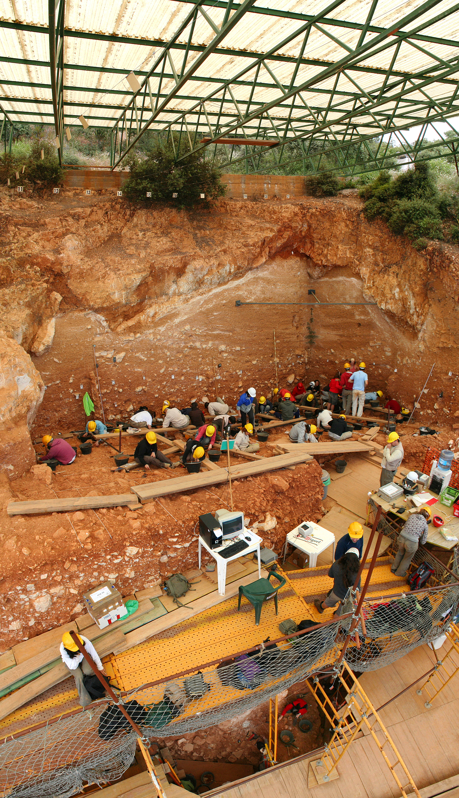
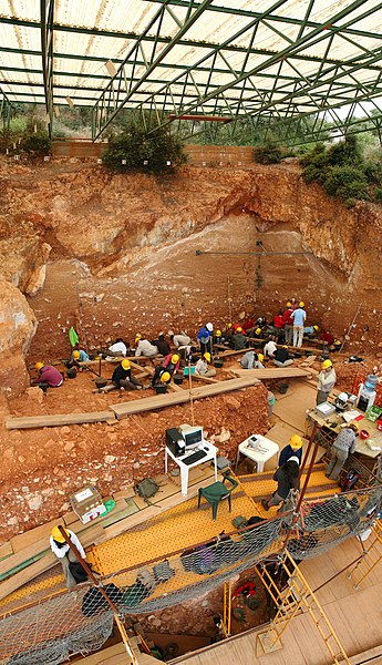
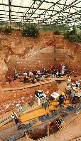
English: Excavations at the site of Gran Dolina, in Atapuerca (Spain), during 2008. Panoramic photography formed using 3 individual photographies with Hugin software. TD-10 archaeological level is being excavated where the most of the people are. It is a Homo heidelbergensis camp. Under the plank, we can observe a woman with red sweatshirt excavating TD-6 archaeological level, where were found the first remains of Homo antecessor.
Español: Excavaciones en el yacimiento de Gran Dolina, en Atapuerca (España), durante el año 2008. Fotografía panorámica formada a partir de 3 fotografías individuales usando Hugin. La excavación en la parte superior se corresponde con el nivel arqueológico TD-10, el cuál es un campamento de Homo heidelbergensis. La parte inferior, debajo de los tablones, se observa a una excavadora con sudadera roja que excava el nivel TD-6, donde aparecieron los restos del Homo antecessor.
Français : Fouilles menées en 2008 sur le site de Gran Dolina dans la Sierra d'Atapuerca, située dans la commune d'Atapuerca dans la province de Burgos en Castille-et-León (Espagne). Image panoramique obtenue en assemblant trois clichés avec le logiciel Hugin. Le niveau archéologique TD10, où se trouvent la plupart des personnes, est un camp d'Homo heidelbergensis. Sous les planches, on distingue une personne travaillant sur le niveau TD6, où ont été trouvés les premiers restes d'Homo antecessor.
Русский: Археологические раскопки в Атапуэрка, близ Гран-Долины (Испания), в 2008 году. |
| 日期 | |
| 来源 | 自己的作品 |
| 作者 | Mario Modesto Mata |
| 其他版本 |
|
.jpg)


| 相机位置 | | 在以下服务上查看本图像和附近其他图像: OpenStreetMap |
|---|
评价
|
本图像被选为2008年11月18日的今日图片。其说明如下: English: Excavations at the site of Gran Dolina, in Atapuerca (Spain), during 2008. 其他语言:
Čeština: Archeologické naleziště „Gran Dolina“ ve španělské oblasti Atapuerca. Byly zde nalezeny pozůstatky tábořišť Homo heidelbergensis a Homo antecessor. Dansk: Udgravningerne i Gran Dolina i Spanien, 2008, af en lejrplads for Homo heidelbergensis. Deutsch: Archäologische Ausgrabungsstätte „Gran Dolina“ im spanischen Atapuerca. Hier wird ein Lager einer Gruppe von Homo heidelbergensis ausgehoben. English: Excavations at the site of Gran Dolina, in Atapuerca (Spain), during 2008. Español: Excavaciones en el yacimiento de Gran Dolina, en Atapuerca (España), durante el año 2008. Fotografía panorámica formada a partir de 3 fotografías individuales usando Hugin. La excavación en la parte superior se corresponde con el nivel arqueológico TD-10, el cuál es un campamento de Homo heidelbergensis. La parte inferior, debajo de los tablones, se observa a una excavadora con sudadera roja que excava el nivel TD-6, donde aparecieron los restos del Homo antecessor. Français : Fouilles archéologiques sur le site de la Gran Dolina à Atapuerca (Espagne). Un groupe d'une trentaine de squelettes d'Homo heidelbergensis remontant à 400 000 ans y a été découvert dans les années 1980. Italiano: Scavi nel sito archeologico di Gran Dolina ad Atapuerca, Spagna. Magyar: Régészeti ásatás az atapuercai Gran Dolina nevű lelőhelyen (Kasztília és León, Spanyolország) Nederlands: de archeologische opgraving "Gran Dolina" in het Spaanse karstgebied Atapuerca, waar een laag met een groep van Homo heidelbergensissen wordt uitgegraven. 中文: 西班牙阿塔普埃尔卡格兰多利纳遗址挖掘 中文(繁體): 西班牙阿塔普埃爾卡格蘭多利納遺址挖掘 |
许可协议
- 您可以自由地:
- 共享 – 复制、发行并传播本作品
- 修改 – 改编作品
- 惟须遵守下列条件:
- 署名 – 您必须对作品进行署名,提供授权条款的链接,并说明是否对原始内容进行了更改。您可以用任何合理的方式来署名,但不得以任何方式表明许可人认可您或您的使用。
- 相同方式共享 – 如果您再混合、转换或者基于本作品进行创作,您必须以与原先许可协议相同或相兼容的许可协议分发您贡献的作品。

|
已授权您依据自由软件基金会发行的无固定段落及封面封底文字(Invariant Sections, Front-Cover Texts, and Back-Cover Texts)的GNU自由文件许可协议1.2版或任意后续版本的条款,复制、传播和/或修改本文件。该协议的副本请见“GNU Free Documentation License”。 |
In using this image or any subsequent derivatives of it, you are required to release the image under the same license. As such, any reproduction of this image, in any medium, must appear with a copy of, or full URL of the license.
Attribution of this image to the author (Mario Modesto Mata) is required in a prominent location near to the image.
No other conditions may be added to, or removed from this license without the permission of the author and copyright holder.Please review the full license requirements carefully before using this image. If you would like to clarify the terms of the license or negotiate less restrictive commercial licensing outside of the bounds of GFDL/CC-BY-SA, please contact me by email, or if you don't have a Wikipedia account you can leave a message on my talk page with your contact details and your request.
Click on the image to see my portfolio

文件历史
点击某个日期/时间查看对应时刻的文件。
| 日期/时间 | 缩略图 | 大小 | 用户 | 备注 | |
|---|---|---|---|---|---|
| 当前 | 2008年9月7日 (日) 13:48 | | 1,500 × 2,607(6.83 MB) | Mario modesto | {{Information |Description={{en|1=Excavations at the site of Gran Dolina, in Atapuerca (Spain), during 2008. Panoramic photography formed using 3 individual photographies with Hugin software. TD-10 archaeological level is being excavated where the most of |
文件用途
以下5个页面使用本文件:
全域文件用途
以下其他wiki使用此文件:
- ar.wikipedia.org上的用途
- ast.wikipedia.org上的用途
- az.wikipedia.org上的用途
- be.wikipedia.org上的用途
- bn.wikipedia.org上的用途
- bs.wikipedia.org上的用途
- ca.wikipedia.org上的用途
- ceb.wikipedia.org上的用途
- crh.wikipedia.org上的用途
- cs.wikipedia.org上的用途
- cv.wikipedia.org上的用途
- da.wikipedia.org上的用途
- de.wikipedia.org上的用途
- de.wikivoyage.org上的用途
- el.wikipedia.org上的用途
- en.wikipedia.org上的用途
- Archaeological excavation
- Portal:Science
- List of World Heritage Sites in Spain
- Wikipedia:Featured pictures/Sciences/Others
- Wikipedia:Featured pictures thumbs/13
- Portal:Paleontology/Selected picture
- Portal:Paleontology/Selected picture/32
- User:Papa Lima Whiskey
- Wikipedia:Wikipedia Signpost/2008-09-29/Features and admins
- Archaeology
- Wikipedia:Featured picture candidates/September-2008
- Wikipedia:Featured picture candidates/Gran Dolina-Atapuerca-Panoramica.jpg
- User talk:Mario modesto
- Wikipedia:Featured picture candidates/Atapuerca
- Wikipedia:Wikipedia Signpost/2008-09-29/SPV
- User:Daniel Mietchen/Science communication gallery
- Wikipedia:Picture of the day/May 2009
- Template:POTD/2009-05-10
- User talk:Papa Lima Whiskey/archive
- 12 Treasures of Spain
- List of World Heritage Sites in Southern Europe
- User:Abyssal/Prehistory of Europe/Selected picture/15
- Wikipedia:Meetup/Boston/WikipediaArchaeology
查看本文件的更多全域用途。