File:Driving standards historic.png

本预览的尺寸:800 × 370像素。 其他分辨率:320 × 148像素 | 640 × 296像素 | 1,357 × 628像素。
原始文件 (1,357 × 628像素,文件大小:36 KB,MIME类型:image/png)

|
File:Driving standards historic.svg是此文件的矢量版本。 如果此文件质量不低于原点阵图,就应该将这个PNG格式文件替换为此文件。
File:Driving standards historic.png → File:Driving standards historic.svg
更多信息请参阅Help:SVG/zh。 |
 |
摘要
| 描述 |
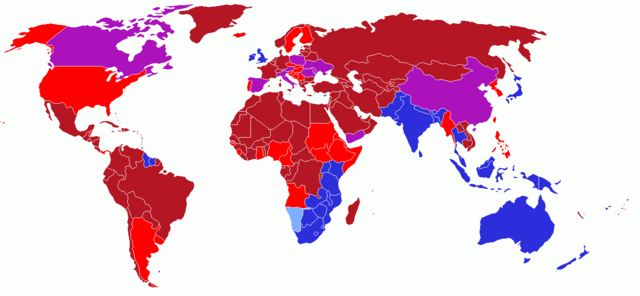
User created world map showing the driving directions for all countries and any changes that have occurred in the past starting with Finland's change in 1858
|
| 日期 | 2006年5月13日 (原始上传日期) |
| 来源 | 无法识别来源。根据版权声明推断为其自己的作品。 |
| 作者 | 无法识别作者。根据版权声明推断作者为UKPhoenix79。 |
许可协议
我,本作品著作权人,特此采用以下许可协议发表本作品:
本文件采用知识共享署名-相同方式共享 2.5 通用许可协议授权。
- 您可以自由地:
- 共享 – 复制、发行并传播本作品
- 修改 – 改编作品
- 惟须遵守下列条件:
- 署名 – 您必须对作品进行署名,提供授权条款的链接,并说明是否对原始内容进行了更改。您可以用任何合理的方式来署名,但不得以任何方式表明许可人认可您或您的使用。
- 相同方式共享 – 如果您再混合、转换或者基于本作品进行创作,您必须以与原先许可协议相同或相兼容的许可协议分发您贡献的作品。
History on English Wikipedia
- (Delete all revisions of this file) (cur) 12:54, 16 June 2006 . . UKPhoenix79 (Talk | contribs | block) . . 1357×628 (19,631 bytes) (retry)
- (del) (rev) 04:59, 16 June 2006 . . UKPhoenix79 (Talk | contribs | block) . . 1357×628 (19,631 bytes) (Looking at a map of the Austro-Hungarian Empire it becae clear that more modern nations had parts that drove on the left)
- (del) (rev) 09:57, 26 May 2006 . . UKPhoenix79 (Talk | contribs | block) . . 1357×628 (19,565 bytes)
- (del) (rev) 08:11, 15 May 2006 . . UKPhoenix79 (Talk | contribs | block) . . 1357×628 (19,547 bytes) (Fixed error)
- (del) (rev) 07:36, 15 May 2006 . . UKPhoenix79 (Talk | contribs | block) . . 1357×628 (19,531 bytes)
- (del) (rev) 17:22, 14 May 2006 . . NFH (Talk | contribs | block) . . 1357×628 (19,312 bytes) (Reverted to earlier revision)
- (del) (rev) 17:21, 14 May 2006 . . NFH (Talk | contribs | block) . . 1357×628 (19,056 bytes) (Reverted to earlier revision)
- (del) (rev) 17:21, 14 May 2006 . . NFH (Talk | contribs | block) . . 1357×628 (19,056 bytes) (Reverted to earlier revision)
- (del) (rev) 23:42, 13 May 2006 . . UKPhoenix79 (Talk | contribs | block) . . 1357×628 (19,312 bytes)
- (del) (rev) 23:39, 13 May 2006 . . UKPhoenix79 (Talk | contribs | block) . . 1357×628 (19,271 bytes)
- (del) (rev) 14:00, 13 May 2006 . . UKPhoenix79 (Talk | contribs | block) . . 1357×628 (19,056 bytes) (User created world map showing historic driving directions for all countries before Finland's change in 1858 Red means driving on right.
Blue means driving on left.
)
文件历史
点击某个日期/时间查看对应时刻的文件。
| 日期/时间 | 缩略图 | 大小 | 用户 | 备注 | |
|---|---|---|---|---|---|
| 当前 | 2018年2月12日 (一) 14:50 | | 1,357 × 628(36 KB) | Maphobbyist | South Sudan border, same color as Sudan |
| 2008年10月7日 (二) 04:25 |  | 1,357 × 628(52 KB) | 8q67n4tqr5 | United States was one drove on left, now drives on right (1792) Category:Right- and left-hand traffic | |
| 2008年10月7日 (二) 04:23 |  | 1,357 × 628(52 KB) | 8q67n4tqr5 | User created world map showing the driving directions for all countries and any changes that have occurred in the past starting with Finland's change in 1858 <font color="#B41624">Red - driving on right; also known as [[Left-hand_drive#Terminology|Right | |
| 2006年7月27日 (四) 14:52 |  | 1,357 × 628(19 KB) | Conscious | newest version from en: | |
| 2006年5月26日 (五) 11:17 |  | 1,357 × 628(19 KB) | UKPhoenix79 | Updated version | |
| 2006年5月13日 (六) 10:16 |  | 1,357 × 628(19 KB) | UKPhoenix79 | User created world map showing historic driving directions for all countries before Finland's change in 1858 <font color="#B41624">Red means driving on right.</font><br /> <font color="#2C2EDC">Blue means driving on left.</font><br /> |
文件用途
没有页面链接到本图像。
全域文件用途
以下其他wiki使用此文件:
- en.wikipedia.org上的用途
- hu.wikipedia.org上的用途
- smn.wikipedia.org上的用途