File:East Anglia UK Locator Map.svg

此SVG文件的PNG预览的大小:494 × 600像素。 其他分辨率:198 × 240像素 | 395 × 480像素 | 633 × 768像素 | 843 × 1,024像素 | 1,687 × 2,048像素 | 1,108 × 1,345像素。
原始文件 (SVG文件,尺寸为1,108 × 1,345像素,文件大小:303 KB)
摘要
| 描述 |
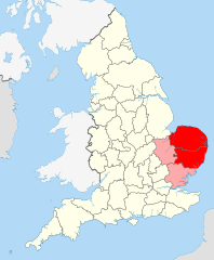
English: Suffolk and Norfolk, the original constituents of East Anglia, are in red. Cambridgeshire – more recently added – in pink.
This image is, inevitably, an approximation and a compromise – it is very hard to properly quantify and emborder East Anglia since it is a completely unofficial region/area. |
||
| 日期 | |||
| 来源 |
|
||
| 作者 | User:Nilfanion User:Wkerry | ||
| SVG开发 |


许可协议
本文件采用知识共享署名-相同方式共享 3.0 未本地化版本许可协议授权。
- 您可以自由地:
- 共享 – 复制、发行并传播本作品
- 修改 – 改编作品
- 惟须遵守下列条件:
- 署名 – 您必须对作品进行署名,提供授权条款的链接,并说明是否对原始内容进行了更改。您可以用任何合理的方式来署名,但不得以任何方式表明许可人认可您或您的使用。
- 相同方式共享 – 如果您再混合、转换或者基于本作品进行创作,您必须以与原先许可协议相同或相兼容的许可协议分发您贡献的作品。
文件历史
点击某个日期/时间查看对应时刻的文件。
| 日期/时间 | 缩略图 | 大小 | 用户 | 备注 | |
|---|---|---|---|---|---|
| 当前 | 2022年5月25日 (三) 15:42 | | 1,108 × 1,345(303 KB) | Judeobasquelanguage | This isn't true, all of us here identify as east anglian, it would be better if you actually asked for the opinions of essexians before denying us our own identity, thanks |
| 2015年12月29日 (二) 23:30 |  | 1,108 × 1,345(302 KB) | Alphathon | Corrected numerous issues introduced in October 2013 revision | |
| 2013年10月23日 (三) 19:05 |  | 1,108 × 1,345(237 KB) | Gymnophoria | As resolved in the Talk page, Essex is part of the East of England governmental region, but not part of East Anglia. Hence Essex has been removed from the image. | |
| 2011年7月6日 (三) 17:58 |  | 1,108 × 1,345(303 KB) | Wkerry |
文件用途
以下页面使用本文件:
全域文件用途
以下其他wiki使用此文件:
- af.wikipedia.org上的用途
- br.wikipedia.org上的用途
- ca.wikipedia.org上的用途
- cy.wikipedia.org上的用途
- de.wikipedia.org上的用途
- en.wikipedia.org上的用途
- East Anglia
- East Anglian English
- User talk:Dpilat
- User talk:Spidergareth
- User talk:Nhyty
- User talk:BaroqueFox
- User talk:AndrewvdBK
- User talk:Thomas888b/Archive 1
- User talk:DJRYRY11
- Wikipedia:WikiProject East Anglia
- Wikipedia:WikiProject East Anglia/Newsletter
- Wikipedia:WikiProject East Anglia/Newsletter2
- User talk:Rcsprinter123/Archives/5
- User talk:Cmglee/archive2011
- User talk:Chrisjj/Archive 1
- es.wikipedia.org上的用途
- eu.wikipedia.org上的用途
- fi.wikipedia.org上的用途
- fr.wikipedia.org上的用途
- fy.wikipedia.org上的用途
- he.wikipedia.org上的用途
- hy.wikipedia.org上的用途
- id.wikipedia.org上的用途
- is.wikipedia.org上的用途
- it.wikipedia.org上的用途
- ja.wikipedia.org上的用途
- ko.wikipedia.org上的用途
- la.wikipedia.org上的用途
- nn.wikipedia.org上的用途
- no.wikipedia.org上的用途
- pl.wikipedia.org上的用途
- pl.wiktionary.org上的用途
- ru.wikipedia.org上的用途
- sh.wikipedia.org上的用途
- simple.wikipedia.org上的用途
- sr.wikipedia.org上的用途
- sv.wikipedia.org上的用途
- tr.wikipedia.org上的用途
- ur.wikipedia.org上的用途
- zh-yue.wikipedia.org上的用途