File:Echmiadzin Cathedral, Armenia.jpg

本预览的尺寸:450 × 600像素。 其他分辨率:180 × 240像素 | 360 × 480像素 | 576 × 768像素 | 768 × 1,024像素 | 1,536 × 2,048像素 | 3,024 × 4,032像素。
原始文件 (3,024 × 4,032像素,文件大小:3.77 MB,MIME类型:image/jpeg)
摘要
| 描述 |
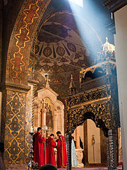
English: Armenia - Day 2 - 19 September 2010. The religious centre of the Armenian Apostolic Church and a UNESCO World Heritage Site. Armenia was the first known country to adopt Christianity as its state religion (301 AD).
The thing that was very noticeable to me as a secular outsider was the sense of community, companionship and warmth in church services. Հայերեն: Էջմածնի Մայր տաճարը |
| 日期 | |
| 来源 | Echmiadzin Cathedral, Armenia |
| 作者 | Shaun Dunphy from Lindfield, United Kingdom |
| 相机位置 | | 在以下服务上查看本图像和附近其他图像: OpenStreetMap |
|---|
许可协议
本文件采用知识共享署名-相同方式共享 2.0 通用许可协议授权。
- 您可以自由地:
- 共享 – 复制、发行并传播本作品
- 修改 – 改编作品
- 惟须遵守下列条件:
- 署名 – 您必须对作品进行署名,提供授权条款的链接,并说明是否对原始内容进行了更改。您可以用任何合理的方式来署名,但不得以任何方式表明许可人认可您或您的使用。
- 相同方式共享 – 如果您再混合、转换或者基于本作品进行创作,您必须以与原先许可协议相同或相兼容的许可协议分发您贡献的作品。
| 这幅图片原始出处为Flickr的https://www.flickr.com/photos/19888921@N00/5046453609 ,作者为sjdunphy 。经机器人FlickreviewR在2011年4月20日审查后确定为采用cc-by-sa-2.0的协议授权使用。 |
文件历史
点击某个日期/时间查看对应时刻的文件。
| 日期/时间 | 缩略图 | 大小 | 用户 | 备注 | |
|---|---|---|---|---|---|
| 当前 | 2011年4月20日 (三) 18:22 | | 3,024 × 4,032(3.77 MB) | FlickreviewR | Replacing image by its original image from Flickr |
| 2011年4月20日 (三) 17:50 |  | 768 × 1,024(594 KB) | Chaojoker | {{Information |Description={{en|Armenia - Day 2 - 19 September 2010. The religious centre of the Armenian Apostolic Church and a UNESCO World Heritage Site. Armenia was the first known country to adopt Christianity as its state religion (301 AD). The thi |
文件用途
以下页面使用本文件:
全域文件用途
以下其他wiki使用此文件:
- ar.wikipedia.org上的用途
- azb.wikipedia.org上的用途
- en.wikivoyage.org上的用途
- it.wikipedia.org上的用途
- it.wikivoyage.org上的用途
- ps.wikivoyage.org上的用途
- tr.wikivoyage.org上的用途