File:Europe-blocs-49-89x4.svg

此SVG文件的PNG预览的大小:800 × 501像素。 其他分辨率:320 × 201像素 | 640 × 401像素 | 1,024 × 642像素 | 1,280 × 802像素 | 2,560 × 1,605像素 | 812 × 509像素。
原始文件 (SVG文件,尺寸为812 × 509像素,文件大小:612 KB)
摘要
| 描述 |
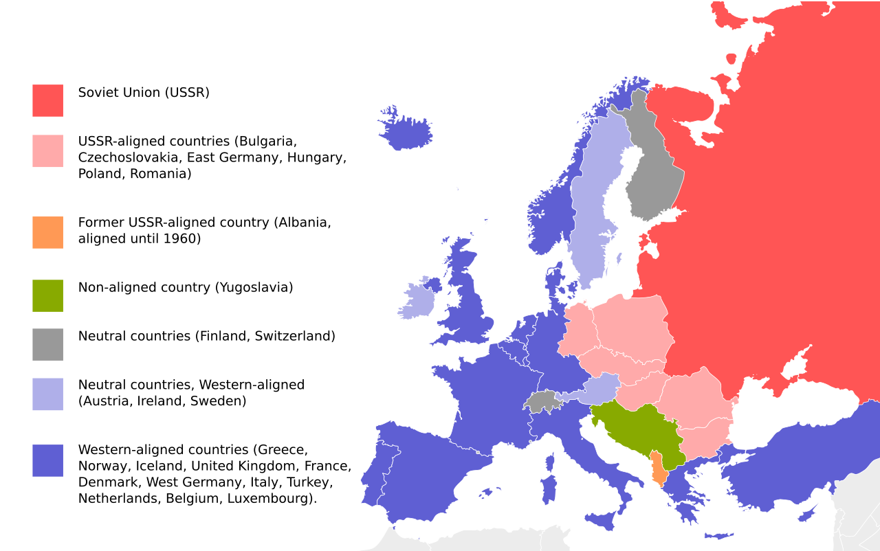
English: Cold War map of Eastern and Western Blocs in Europe. Map based on File:EU27-further_enlargement_map.svg |
| 日期 | |
| 来源 | File:EU27-further_enlargement_map.svg |
| 作者 | UserGoldsztajn |
| 其他版本 |
[]
|


许可协议
| 我,本作品著作权人,释出本作品至公有领域。这适用于全世界。 在一些国家这可能不合法;如果是这样的话,那么: 我无条件地授予任何人以任何目的使用本作品的权利,除非这些条件是法律规定所必需的。 |
| 註解 | 該圖片含有註解:在維基媒體共享資源上查看註解 |
文件历史
点击某个日期/时间查看对应时刻的文件。
| 日期/时间 | 缩略图 | 大小 | 用户 | 备注 | |
|---|---|---|---|---|---|
| 当前 | 2023年10月2日 (一) 19:33 | | 812 × 509(612 KB) | Gooduserdude | Reverted to version as of 22:37, 1 June 2019 (UTC) |
| 2023年9月18日 (一) 22:58 |  | 812 × 509(238 KB) | Quetz72 | File uploaded using svgtranslate tool (https://svgtranslate.toolforge.org/). Added translation for ca. | |
| 2022年4月1日 (五) 04:10 |  | 812 × 509(237 KB) | Yle-radio 1 | * | |
| 2019年6月1日 (六) 22:37 |  | 812 × 509(612 KB) | Pedro8790 | Reverted to version as of 18:19, 22 September 2018 (UTC) | |
| 2019年5月30日 (四) 17:46 |  | 800 × 501(198 KB) | Koldo Biguri | Translated into Basque | |
| 2018年9月22日 (六) 18:19 |  | 812 × 509(612 KB) | Nablicus | correction France | |
| 2018年7月13日 (五) 12:06 |  | 812 × 509(694 KB) | Nablicus | France was not neutral | |
| 2009年4月2日 (四) 07:29 |  | 812 × 509(694 KB) | Goldsztajn | reedit | |
| 2009年4月2日 (四) 07:09 |  | 812 × 509(694 KB) | Goldsztajn | reedit | |
| 2009年4月2日 (四) 06:58 |  | 812 × 509(671 KB) | Goldsztajn | reedit |
文件用途
全域文件用途
以下其他wiki使用此文件:
- ar.wikipedia.org上的用途
- az.wikipedia.org上的用途
- bn.wikipedia.org上的用途
- ca.wikipedia.org上的用途
- cs.wikipedia.org上的用途
- da.wikipedia.org上的用途
- de.wikipedia.org上的用途
- de.wiktionary.org上的用途
- el.wikipedia.org上的用途
- en.wikipedia.org上的用途
- Western Europe
- Eastern Bloc
- Western Bloc
- Contemporary history
- Foreign policy of Vladimir Putin
- Talk:Eastern Bloc/Archive 1
- Wikipedia:Graphics Lab/Image workshop/Archive/Jun 2009
- Talk:Eastern Bloc/Archive 2
- Portal:Modern history
- User:Falcaorib
- Cyprus–Yugoslavia relations
- Malta–Yugoslavia relations
- User:Al83tito/sandbox4
- en.wikibooks.org上的用途
- en.wikivoyage.org上的用途
- en.wiktionary.org上的用途
- es.wikipedia.org上的用途
- es.wikivoyage.org上的用途
- ext.wikipedia.org上的用途
- fa.wikipedia.org上的用途
- he.wikipedia.org上的用途
- hr.wikipedia.org上的用途
- hy.wikipedia.org上的用途
- is.wikipedia.org上的用途
- ja.wikipedia.org上的用途
- ko.wikipedia.org上的用途
- li.wikipedia.org上的用途
- ml.wikipedia.org上的用途
- no.wikipedia.org上的用途
- pl.wikipedia.org上的用途
- pt.wikipedia.org上的用途
查看本文件的更多全域用途。