File:Europe 1812 map en.png

本预览的尺寸:800 × 526像素。 其他分辨率:320 × 211像素 | 640 × 421像素 | 1,024 × 674像素 | 1,280 × 842像素 | 2,284 × 1,503像素。
原始文件 (2,284 × 1,503像素,文件大小:1.14 MB,MIME类型:image/png)
摘要

|
此historical map图片可使用矢量图形重新创建为SVG文件。这具有很多好处;更多信息请参见共享资源:待清理媒体。如果存在此图片的SVG格式,请将其上传,然后将此模板替换为
{{vector version available|新图片名称}}。
建议您将SVG命名为“Europe 1812 map en.svg”,这样在使用Vector version available(或Vva)模板时就不需要填写新图片名称参数。 |
| 描述 |
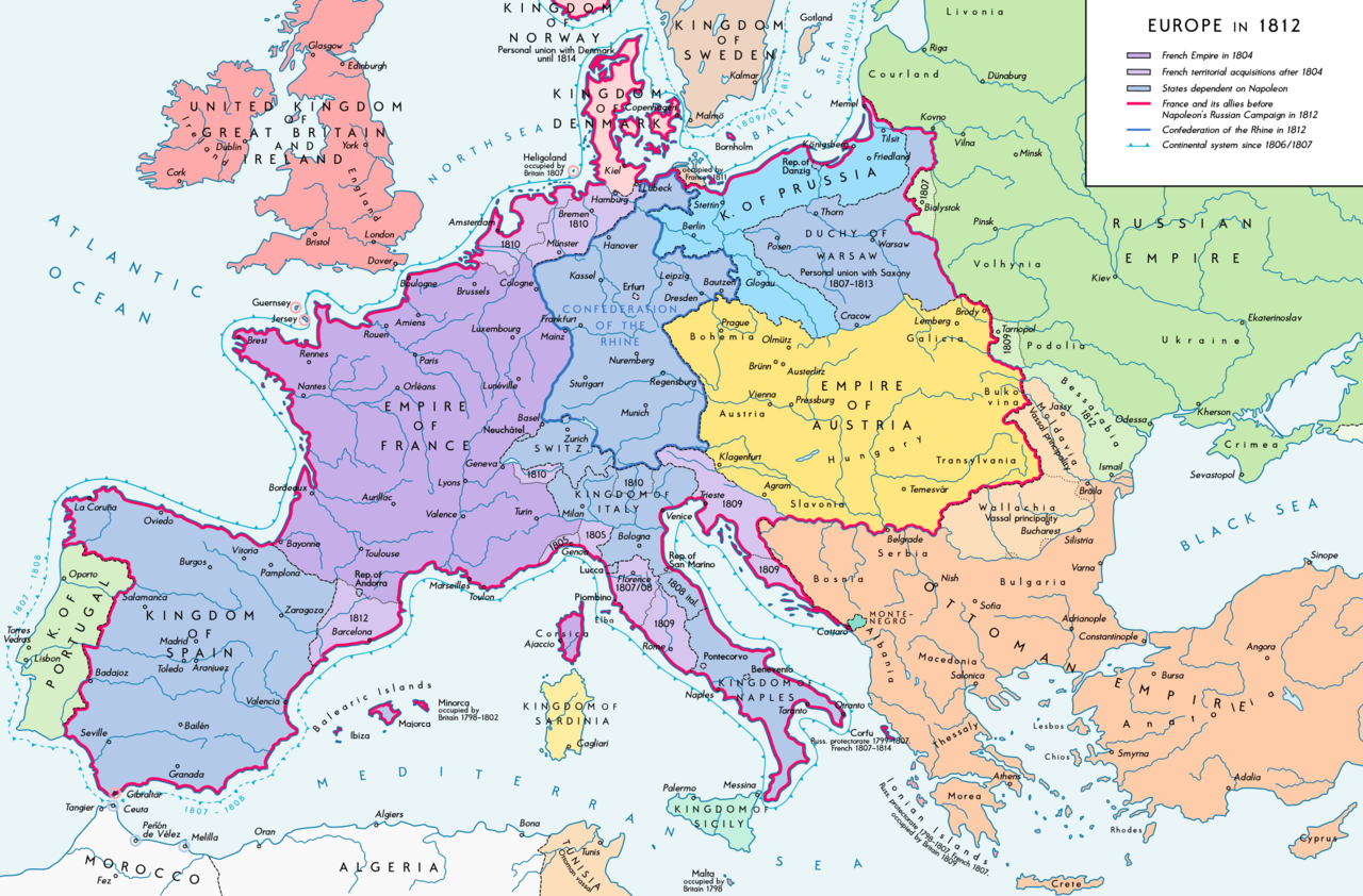
Deutsch: Europa 1812. Politische Ausgangslage vor Napeoleons Russlandfelzug. English: Europe in 1812. Political situation before Napoleon's Russian Campaign. |
| 日期 | |
| 来源 |
自己的作品. Source of Information: – Map "L'apogée de l'Empire Français (avant la campagne de Russie)" (Author unknown)(Link) – Dr. Walter Leiserung (ed.): Historischer Weltatlas, Marix Verlag, Wiesbaden 2004, ISBN 978-3-937715-59-9 – Zentralinstitut für Geschichte der Akademie der Wissenschaften der DDR (ed.): Atlas zur Geschichte, Band 1, VEB Hermann Haack, Gotha 1989, ISBN 3-7301-0040-8 – Prof. Dr. Vadim Oswalt, Prof. Dr. Hans Ulrich Rudolf (ed.): Klett-Perthes Atlas zur Weltgeschichte, Ernst Klett Verlag, Stuttgart 2011, ISBN 978-3-12-828194-0 – Ferenc Majoros u. Bernd Rill: Das Osmanische Reich 1300-1922. Die Geschichte einer Großmacht, Lzenzausgabe für Weltbild Verlag, Augsburg 2000, ISBN 3-8289-0336-3 |
| 作者 | Alexander Altenhof |
| 其他版本 |
|


_en.png)
.png)
.jpg)
许可协议
我,本作品著作权人,特此采用以下许可协议发表本作品:
本文件采用知识共享署名-相同方式共享 3.0 未本地化版本许可协议授权。
- 您可以自由地:
- 共享 – 复制、发行并传播本作品
- 修改 – 改编作品
- 惟须遵守下列条件:
- 署名 – 您必须对作品进行署名,提供授权条款的链接,并说明是否对原始内容进行了更改。您可以用任何合理的方式来署名,但不得以任何方式表明许可人认可您或您的使用。
- 相同方式共享 – 如果您再混合、转换或者基于本作品进行创作,您必须以与原先许可协议相同或相兼容的许可协议分发您贡献的作品。
文件历史
点击某个日期/时间查看对应时刻的文件。
| 日期/时间 | 缩略图 | 大小 | 用户 | 备注 | |
|---|---|---|---|---|---|
| 当前 | 2016年9月11日 (日) 15:26 | | 2,284 × 1,503(1.14 MB) | KaterBegemot | Border corrections at Thorn and Tarnopol area, minor kerning and positioning changes |
| 2016年7月20日 (三) 00:47 |  | 2,284 × 1,503(1.14 MB) | KaterBegemot | Added Bukovina / Corrected spelling of Sevastopol, Courland, Belgrade, Duchy of Warsaw / Marked Corfu as territory under French influence (red) / Correct position of city points of Basel, Geneva, Toulouse / Minor border corrections / Better kerning / T... | |
| 2016年7月14日 (四) 00:21 |  | 2,284 × 1,503(1.14 MB) | KaterBegemot | Added P. of Neuchatel, Ekaterinoslav, Varna, Brăila / Corrected borders of Montenegro, Milan-Genoa area | |
| 2015年12月3日 (四) 00:43 |  | 2,284 × 1,503(1.09 MB) | Ras67 | frame cropped | |
| 2015年11月29日 (日) 11:31 |  | 2,293 × 1,512(1.12 MB) | Spiridon Ion Cepleanu | Some details & corrections in the Austrian & Ottoman empires, according with « Grosser Atlas zur Weltgeschichte » (H.E.Stier, dir.) Westermann 1985, ISBN 3-14-100919-8, « Putzger historischer Weltatlas Cornelsen » 1990, ISBN 3-464-00176-8, « Atlas... | |
| 2013年10月5日 (六) 21:47 |  | 2,293 × 1,512(1.01 MB) | KaterBegemot | Corrected boundaries of Switzerland, Prussia and Circassia | |
| 2012年9月15日 (六) 23:53 |  | 2,293 × 1,512(1.01 MB) | KaterBegemot | == {{int:filedesc}} == {{Information |Description= {{de|1=Europa 1812. Politische Ausgangslage vor Napeoleons Russlandfelzug.}}{{en|1=Europe in 1812. Political situation before Napoleon's Russian Campaign.}} |Source={{Own}}. Source of Information: </br... |
文件用途
全域文件用途
以下其他wiki使用此文件:
- af.wikipedia.org上的用途
- azb.wikipedia.org上的用途
- br.wikipedia.org上的用途
- ca.wikipedia.org上的用途
- ce.wikipedia.org上的用途
- cs.wikipedia.org上的用途
- da.wikipedia.org上的用途
- de.wikipedia.org上的用途
- el.wikipedia.org上的用途
- en.wikipedia.org上的用途
- History of Austria
- Napoleonic Wars
- Puppet state
- Napoleon
- Client state
- Klemens von Metternich
- France in the long nineteenth century
- Ideas of European unity before 1948
- Principality of Erfurt
- First French Empire
- Territorial evolution of France
- French invasion of Russia
- Alexander I of Russia
- Wikipedia talk:GLAM/Israel Museum, Jerusalem
- French period
- History of French foreign relations
- List of French client states
- International relations (1648–1814)
- Conference of Dresden (1812)
- User:Falcaorib
- en.wikibooks.org上的用途
- eo.wikipedia.org上的用途
- es.wikipedia.org上的用途
- fi.wikipedia.org上的用途
- fr.wikipedia.org上的用途
- fy.wikipedia.org上的用途
- hr.wikipedia.org上的用途
查看本文件的更多全域用途。