File:Extent of the Hansa.png

本预览的尺寸:800 × 445像素。 其他分辨率:320 × 178像素 | 640 × 356像素 | 1,250 × 695像素。
原始文件 (1,250 × 695像素,文件大小:141 KB,MIME类型:image/png)
| 描述 |
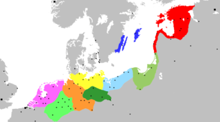
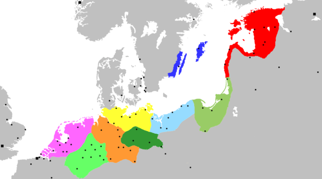
Map of the Hanseatic League, circa 1400, showing Circles, Kontore and principal Hanseatic cities Netherlands Circle
Westphalian Circle
Saxon Circle
Wendish Circle
Margravian Circle
Pomeranian Circle
Prussian Circle
Livonian Circle
Swedish Circle
Squares indicate Kontore; dots indicate Hanseatic cities. |
||
| 日期 | (UTC) | ||
| 来源 | Adapted from Image:Extent of the Hansa.jpg, itself in the public domain because its first publication occurred in 1902 — prior to January 1, 1923 | ||
| 作者 | OwenBlacker | ||
| 授权 (二次使用本文件) |
|
||
| 其他版本 | Image:Extent of the Hansa.jpg |
文件历史
点击某个日期/时间查看对应时刻的文件。
| 日期/时间 | 缩略图 | 大小 | 用户 | 备注 | |
|---|---|---|---|---|---|
| 当前 | 2007年11月20日 (二) 00:12 | | 1,250 × 695(141 KB) | OwenBlacker | {{Information |Description= Map of the Hanseatic League, circa 1400, showing Circles, ''Kontore'' and principal Hanseatic cities |Source= Adapted from Image:Extent of the Hansa.jpg |Date=~~~~~ |Author=~~~ |Permission={{PD-self}} |other_versio |
文件用途
全域文件用途
以下其他wiki使用此文件:
- af.wikipedia.org上的用途
- ar.wikipedia.org上的用途
- برلين
- تالين
- هامبورغ
- ستوكهولم
- ريغا
- لندن
- براونشفايغ (مدينة)
- كولونيا
- بريمن
- ماغديبورغ
- الرابطة الهانزية
- نيوكاسل أبون تاين
- إبسوتش
- روستوك
- بوخوم
- دورتموند
- مونستر
- دويسبورغ
- شتاده
- لونبورغ
- ستارغارد
- كيل
- كراكوف
- فروتسواف
- برغن
- لوبيك
- كالينينغراد
- بيتيرهوف
- بسكوف
- فيليكي نوفغورود
- إرفورت
- كينغستون أبون هال
- أنتويرب
- بروج
- يورك
- كاوناس
- تارتو
- بوسطن (إنجلترا)
- أوسنابروك
- تورون
- هام (مدينة)
- غدانسك
- مولهاوزن (تورينغيا)
- هاله (سكسونيا-أنهالت)
- قالب:الرابطة الهانزية
- فيسبي
- هاردرفايك
- كونيغسبرغ
- خرننغن
查看本文件的更多全域用途。