File:FRYugoMap2k.jpg

此为最大尺寸。
FRYugoMap2k.jpg (351 × 378像素,文件大小:116 KB,MIME类型:image/jpeg)
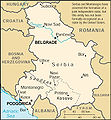
This is a map of The Federal Republic of Yugoslavia (Serbia and Montenegro) [FRY (S&M)] from as the 2000 CIA World Factbook as mirrored by the PCL.
[]
-

-
 English 2000
 -
 English 2006
 -
 English 2006
 -
 English 2008
 -
 English 2008
 -
 español 2008
 -
 magyar 2008


|
|
 |
文件历史
点击某个日期/时间查看对应时刻的文件。
| 日期/时间 | 缩略图 | 大小 | 用户 | 备注 | |
|---|---|---|---|---|---|
| 当前 | 2007年2月6日 (二) 05:18 | | 351 × 378(116 KB) | Hoshie | This is a map of The Federal Republic of Yugoslavia (Serbia and Montenegro) [FRY (S&M)] from as the [http://www.umsl.edu/services/govdocs/wofact2000/geos/sr.html 2000 CIA World Factbook] as mirrored by the [http://ww |
文件用途
以下页面使用本文件:
全域文件用途
以下其他wiki使用此文件:
- en.wikipedia.org上的用途
- es.wikipedia.org上的用途
- fa.wikipedia.org上的用途
- fr.wikipedia.org上的用途
- ja.wikipedia.org上的用途
- kk.wikipedia.org上的用途
- mr.wikipedia.org上的用途
- nl.wikipedia.org上的用途
- vi.wikipedia.org上的用途