File:Fitow 06 sept 2007 0415Z.jpg

原始文件 (6,000 × 7,800像素,文件大小:6.17 MB,MIME类型:image/jpeg)
摘要
| 描述 |
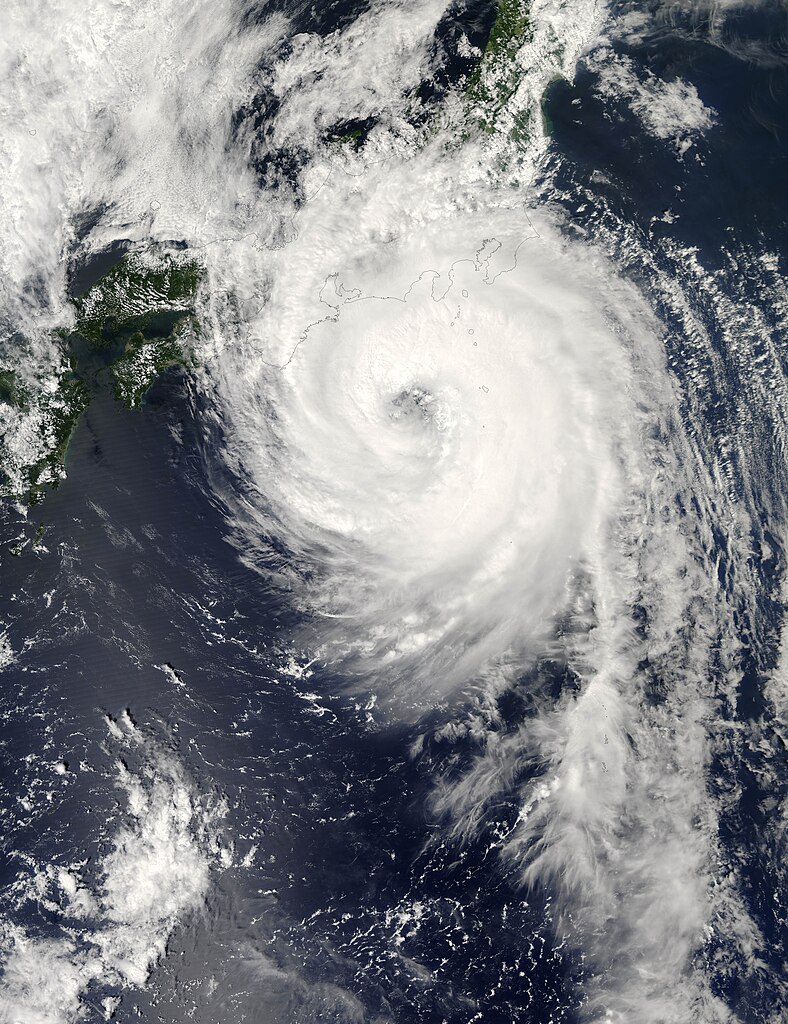
The Moderate Resolution Imaging Spectroradiometer (MODIS) on NASA’s Aqua satellite acquired this photo-like image of Typhoon Fitow approaching Japan at 1:15 p.m. local time (4:15 UTC) on September 6, 2007. Roughly an hour later, the Joint Typhoon Warning Center estimated Fitow’s sustained winds to be over 160 kilometers per hour (100 miles per hour), putting the storm at Category Two strength. The satellite image shows Fitow to have tightly wound bands of clouds around a well-defined, though cloud-filled eye, and towering thunderstorms characteristic of powerful tropical storm systems (the generic name for typhoon, hurricanes, and tropical cyclones). At the time MODIS observed Typhoon Fitow, the storm’s outer edges were bringing winds and rain to Tokyo and strong storm surge to coastal areas on the islands of Honshu, Kyushu, and Skikoku. Typhoon Fitow became a named storm on August 29, 2007. The storm system gradually built in power as it drew towards the main islands of Japan, briefly reaching Category Two strength, then weakening to Category One, before rebuilding again. It was forecast to reach Honshu, the largest island in Japan on September 6, then track over the island and lose power. “Fitow” is a Micronesian word for a flower found on the island of Yap. The list of names of western Pacific storms, provided by the Hong Kong Observatory, draws on Asian languages. The high-resolution image provided above is at MODIS’ full spatial resolution (level of detail) of 250 meters per pixel. The MODIS Rapid Response System provides this image at additional resolutions. |
|||||
| 日期 | ||||||
| 来源 | http://earthobservatory.nasa.gov/NaturalHazards/natural_hazards_v2.php3?img_id=14496 | |||||
| 作者 | NASA image by Jeff Schmaltz, MODIS Rapid Response Team, Goddard Space Flight Center. | |||||
| 授权 (二次使用本文件) |
|

文件历史
点击某个日期/时间查看对应时刻的文件。
| 日期/时间 | 缩略图 | 大小 | 用户 | 备注 | |
|---|---|---|---|---|---|
| 当前 | 2007年9月7日 (五) 00:52 | | 6,000 × 7,800(6.17 MB) | Good kitty | == Summary == {{Information |Description=The Moderate Resolution Imaging Spectroradiometer (MODIS) on NASA’s Aqua satellite acquired this photo-like image of Typhoon Fitow approaching Japan at 1:15 p.m. local time (4:15 UTC) on September 6, 2007. Roughl |
文件用途
以下2个页面使用本文件:
全域文件用途
以下其他wiki使用此文件:
- de.wikipedia.org上的用途
- en.wikipedia.org上的用途
- ja.wikipedia.org上的用途
- pl.wikinews.org上的用途
- pt.wikipedia.org上的用途