File:Fragments of Larsen B Ice Shelf Lingered Until 2005.gif

本预览的尺寸:600 × 600像素。 其他分辨率:240 × 240像素 | 480 × 480像素 | 768 × 768像素 | 1,024 × 1,024像素 | 1,600 × 1,600像素。
原始文件 (1,600 × 1,600像素,文件大小:4.98 MB,MIME类型:image/gif、循环、3帧、6.0秒)
摘要
| 描述 |
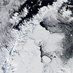
English: The first image was taken one year after the disintegration. Although not frozen solid, the bay is filled with mélange and icebergs, some of them tens of kilometres long. A thin corridor of open ocean, however, lines much of the remaining ice shelf. In the second image, ice continues to fill the bay, and even more ice appears in this image than is visible in the previous shot. Lingering mélange (small chunks of glacier ice and snow, sometimes mixed with sea ice) and icebergs have likely been supplemented by snow and sea ice. The difference between the last image and earlier shots is dramatic. Most of the ice that had lingered in the bay after the Larsen B’s collapse has drifted out to sea, and open ocean predominates. Isolated chunks of ice float on the sea surface far from the remaining edge of the shelf. |
| 日期 | |
| 来源 | NASA Earth Observatory |
| 作者 | Jesse Allen and Robert Simmon |
The Moderate Resolution Imaging Spectroradiometer (MODIS) on NASA’s Terra and Aqua satellites captured these images in the years following the collapse.
许可协议
| 本文件完全由NASA创作,在美国属于公有领域。根据NASA的版权方针,NASA的材料除非另有声明否则不受版权保护。(参见Template:PD-USGov/zh、NASA版权方针页面或JPL图片使用方针。) | ||
 |
警告:
|
文件历史
点击某个日期/时间查看对应时刻的文件。
| 日期/时间 | 缩略图 | 大小 | 用户 | 备注 | |
|---|---|---|---|---|---|
| 当前 | 2010年4月9日 (五) 09:17 | | 1,600 × 1,600(4.98 MB) | Originalwana | {{Information |Description={{en|1=The first image was taken one year after the disintegration. Although not frozen solid, the bay is filled with mélange and icebergs, some of them tens of kilometres long. A thin corridor of open [[:Category:O |
文件用途
以下页面使用本文件:
全域文件用途
以下其他wiki使用此文件:
- ast.wikipedia.org上的用途
- en.wikipedia.org上的用途
- es.wikipedia.org上的用途
- fr.wikipedia.org上的用途
- hr.wikipedia.org上的用途
- it.wikipedia.org上的用途
- lv.wikipedia.org上的用途
- nn.wikipedia.org上的用途
- no.wikipedia.org上的用途
- pl.wikipedia.org上的用途
- sh.wikipedia.org上的用途
- uk.wikipedia.org上的用途