File:Freedom of Panorama in Europe.svg

此SVG文件的PNG预览的大小:713 × 599像素。 其他分辨率:286 × 240像素 | 571 × 480像素 | 914 × 768像素 | 1,218 × 1,024像素 | 2,437 × 2,048像素 | 828 × 696像素。
原始文件 (SVG文件,尺寸为828 × 696像素,文件大小:700 KB)
摘要
| 描述 |
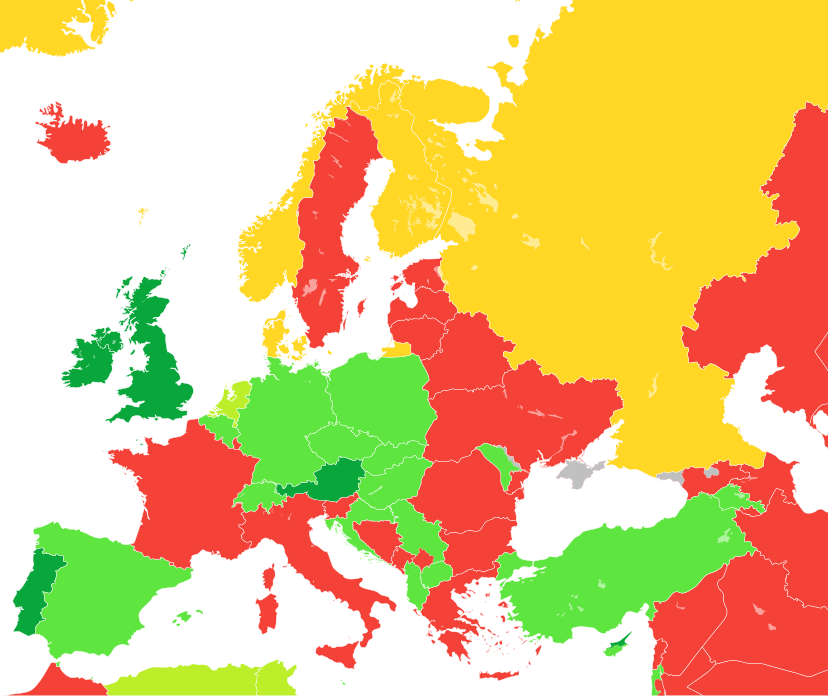
Deutsch: Übersichtskarte über den Geltungsbereich der Panoramafreiheit in den Ländern Europas (aus dem für Wikimedia Commons relevanten Standpunkt).
English: A map showing the level of Freedom of Panorama (as seen from the Wikimedia Commons standpoint) in the countries of Europe as well as parts of Western Asia and North Africa
Español: Mapa que ilustra las categorías de la libertad de panorama (desde la perpectiva de Wikimedia Commons) en los países europeos.
Français : Carte montrant le niveau liberté de Panorama (du point de vue de Wikimedia Commons) dans les pays d'Europe.
Italiano: Mappa che illustra la situazione della c.d. libertà di panorama (dal punto di vista di Wikimedia Commons) nei Paesi europei.
日本語: ヨーロッパ諸国の風景の自由 (英語版) (ウィキメディア・コモンズの見解による) の程度。
Nederlands: Kaart tonende het niveau van de panoramavrijheid (vanuit het Wikimedia Commons oogpunt) van de Europese landen.
Tagalog: Isang mapa na nagpapakita ng mga antas ng kalayaan sa panorama (sang-ayon sa pananaw ng Wikimedia Commons) sa mga bansang Europeo.
中文:一張地圖,顯示了歐洲國家的全景自由(從維基共享資源的角度來看)。
NL: Public interiors are OK, but schools, opera buildings, entrance halls of businesses, and museums are not public places for the purpose of Dutch law, while railway stations are.
OK, including public interiors
OK
OK for buildings only
Not OK (Note: this is from the Wikimedia Commons standpoint, so includes countries with non-commercial FOP)
Inconclusive or unknown (only Andorra, San Marino, Monaco, Crimea, and Sweden are marked as "Inconclusive or unknown") |
| 日期 | / 2010年4月20日, 16:49 (UTC) (原始上传日期) |
| 来源 |
本檔案衍生自: Blank map of Europe cropped.svg |
| 作者 |
|
| 其他版本 |
|
| SVG开发 |
.png)
.svg)


.svg)
许可协议
我,本作品著作权人,特此采用以下许可协议发表本作品:
本文件采用知识共享署名-相同方式共享 3.0 未本地化版本许可协议授权。
- 您可以自由地:
- 共享 – 复制、发行并传播本作品
- 修改 – 改编作品
- 惟须遵守下列条件:
- 署名 – 您必须对作品进行署名,提供授权条款的链接,并说明是否对原始内容进行了更改。您可以用任何合理的方式来署名,但不得以任何方式表明许可人认可您或您的使用。
- 相同方式共享 – 如果您再混合、转换或者基于本作品进行创作,您必须以与原先许可协议相同或相兼容的许可协议分发您贡献的作品。
原始上传日志
This image is a derivative work of the following images:
- File:Blank map of Europe cropped.svg licensed with Cc-by-sa-2.5
- 2010-04-20T15:38:55Z Quibik 645x690 (266750 Bytes) Serbia had a wrong ISO code.
- 2010-04-20T14:50:17Z Quibik 645x690 (266733 Bytes) RSVG's rendering failed, trying to fix
- 2010-04-20T14:45:48Z Quibik 645x690 (264475 Bytes) further cleanup
- 2009-04-30T19:51:36Z Insuranze 645x690 (269667 Bytes) code cleanup
- 2007-06-07T22:58:16Z Revolus 645x690 (540660 Bytes) {{Information | Description=Cropped version of [[:Image:Blank map of Europe.svg|Blank map of Europe.svg]] as descriped by its author. {{en|A blank Map of Europe in SVG format. Every country has an id which is its ISO-3116-1-
Uploaded with derivativeFX
文件历史
点击某个日期/时间查看对应时刻的文件。
| 日期/时间 | 缩略图 | 大小 | 用户 | 备注 | |
|---|---|---|---|---|---|
| 当前 | 2023年10月21日 (六) 15:51 | | 828 × 696(700 KB) | Golden | update Artsakh |
| 2023年2月13日 (一) 17:15 |  | 828 × 696(704 KB) | TilmannR | Reverted to previous version. Major changes should be discussed and more carefully planned. | |
| 2023年2月13日 (一) 15:28 |  | 828 × 696(716 KB) | Amitchell125 | colours replaced to suit people who are colour-blind | |
| 2022年4月17日 (日) 15:38 |  | 828 × 696(704 KB) | Saippuakauppias | Crimea grey, cf. Discussion | |
| 2021年10月26日 (二) 10:12 |  | 828 × 696(704 KB) | Brateevsky | Smaller map with Kazakhstan and Caucasus states | |
| 2021年10月26日 (二) 06:44 |  | 1,078 × 697(704 KB) | Brateevsky | Reverted to version as of 07:03, 4 September 2021 (UTC): Kazakhstan and Azerbaijan are European countries | |
| 2021年10月9日 (六) 09:40 |  | 593 × 606(704 KB) | Chubit | ... | |
| 2021年9月4日 (六) 07:03 |  | 1,078 × 697(704 KB) | Chubit | Algeria and Tunisia to grass green | |
| 2021年8月25日 (三) 05:02 |  | 593 × 606(704 KB) | Chubit | Adjust the border | |
| 2021年8月3日 (二) 11:57 |  | 512 × 454(310 KB) | Bes-ART | Added a new map with all european countries, including microstates and kosovo. Colors are also standard used on the world map for the same subject. Crimea and Sweden are gray as it is unknown the status. |
文件用途
以下页面使用本文件:
全域文件用途
以下其他wiki使用此文件:
- az.wikipedia.org上的用途
- ca.wikipedia.org上的用途
- de.wikipedia.org上的用途
- de.wikivoyage.org上的用途
- dk.wikimedia.org上的用途
- en.wikipedia.org上的用途
- eo.wikipedia.org上的用途
- es.wikipedia.org上的用途
- ee.wikimedia.org上的用途
- fa.wikipedia.org上的用途
- fr.wikipedia.org上的用途
- ga.wikipedia.org上的用途
- gl.wikipedia.org上的用途
- he.wikipedia.org上的用途
- hr.wikipedia.org上的用途
- ja.wikipedia.org上的用途
查看本文件的更多全域用途。