File:GIUK gap.png

本预览的尺寸:495 × 599像素。 其他分辨率:198 × 240像素 | 397 × 480像素 | 635 × 768像素 | 1,024 × 1,239像素。
原始文件 (1,024 × 1,239像素,文件大小:769 KB,MIME类型:image/png)

|
此map图片可使用矢量图形重新创建为SVG文件。这具有很多好处;更多信息请参见共享资源:待清理媒体。如果存在此图片的SVG格式,请将其上传,然后将此模板替换为
{{vector version available|新图片名称}}。
建议您将SVG命名为“GIUK gap.svg”,这样在使用Vector version available(或Vva)模板时就不需要填写新图片名称参数。 |
摘要
| 描述 | This is a PNG version of "Guik gap.gif" as it appeared on the English Wikipedia. As it has been recommended that the GIF version is replaced by a PNG or SVG version, I converted the original GIF to PNG and uploaded it to Wikimedia Commons instead. All I have done is convert the image to PNG, and rename it to "GIUK_gap" instead of "Guik gap", in correspondance with the Wikipedia article on the GIUK gap. |
| 来源 | https://www.cia.gov/csi/monograph/coldwar/pg9.gif |
| 作者 | |
| 其他版本 | http://en.wikipedia.org/wiki/Image:Guik_gap.gif |
Original GIF summary
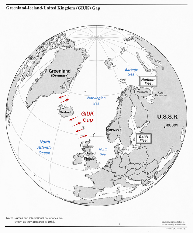
The GIUK gap is an area in the northern Atlantic Ocean that forms a naval warfare chokepoint. Its name is an acronym for Greenland, Iceland, and the United Kingdom, the gap being the open ocean between these three landmasses. The term is typically used in military topics.
source: https://www.cia.gov/csi/monograph/coldwar/pg9.gif
许可协议
此作品在美国属于公有领域,因为其是由美国政府的官员或雇员,基于其个人公务目的制作的作品,参考美国法典第17篇第1章第105条。
注意︰本模板仅适用于美国联邦政府的原创作品,不适用于任何美国州、属地、联邦个体、县、市或任何次级政府的作品。本模板也不适用于1978年以后由美国邮政署出版的邮票图案(参看美国版权局实践纲领第313.6(C)(1)条)。也不适用于部分美国硬币;参看美国铸币局使用条款。 |
 | |
| 本文件已被确认为免除已知的著作权法限制(包括所有相关权利)。 | ||
文件历史
点击某个日期/时间查看对应时刻的文件。
| 日期/时间 | 缩略图 | 大小 | 用户 | 备注 | |
|---|---|---|---|---|---|
| 当前 | 2023年9月12日 (二) 21:34 | | 1,024 × 1,239(769 KB) | Hohum | Colours for clarity |
| 2007年2月11日 (日) 19:03 |  | 1,024 × 1,239(431 KB) | Gspr~commonswiki | This is a PNG version of "Guik gap.gif" as it appeared on the English Wikipedia. It has been recommended that the GIF version is replaced by a PNG or SVG version, and I thought I might aswell upload this PNG conversion to Wikimedia Commons instead of Wiki |
文件用途
以下2个页面使用本文件:
全域文件用途
以下其他wiki使用此文件:
- ar.wikipedia.org上的用途
- da.wikipedia.org上的用途
- de.wikipedia.org上的用途
- en.wikipedia.org上的用途
- es.wikipedia.org上的用途
- et.wikipedia.org上的用途
- fa.wikipedia.org上的用途
- fi.wikipedia.org上的用途
- fr.wikipedia.org上的用途
- hu.wikipedia.org上的用途
- hy.wikipedia.org上的用途
- ia.wikipedia.org上的用途
- it.wikipedia.org上的用途
- ja.wikipedia.org上的用途
- ko.wikipedia.org上的用途
- nn.wikipedia.org上的用途
- no.wikipedia.org上的用途
- ro.wikipedia.org上的用途
- ru.wikipedia.org上的用途
- sk.wikipedia.org上的用途
- sl.wikipedia.org上的用途
- sv.wikipedia.org上的用途
- tr.wikipedia.org上的用途
- uk.wikipedia.org上的用途
- vi.wikipedia.org上的用途
- www.wikidata.org上的用途