File:Geographic map of Somaliland.svg

此SVG文件的PNG预览的大小:800 × 506像素。 其他分辨率:320 × 202像素 | 640 × 405像素 | 1,024 × 648像素 | 1,280 × 810像素 | 2,560 × 1,619像素 | 4,110 × 2,600像素。
原始文件 (SVG文件,尺寸为4,110 × 2,600像素,文件大小:11.09 MB)
摘要
| 描述 |
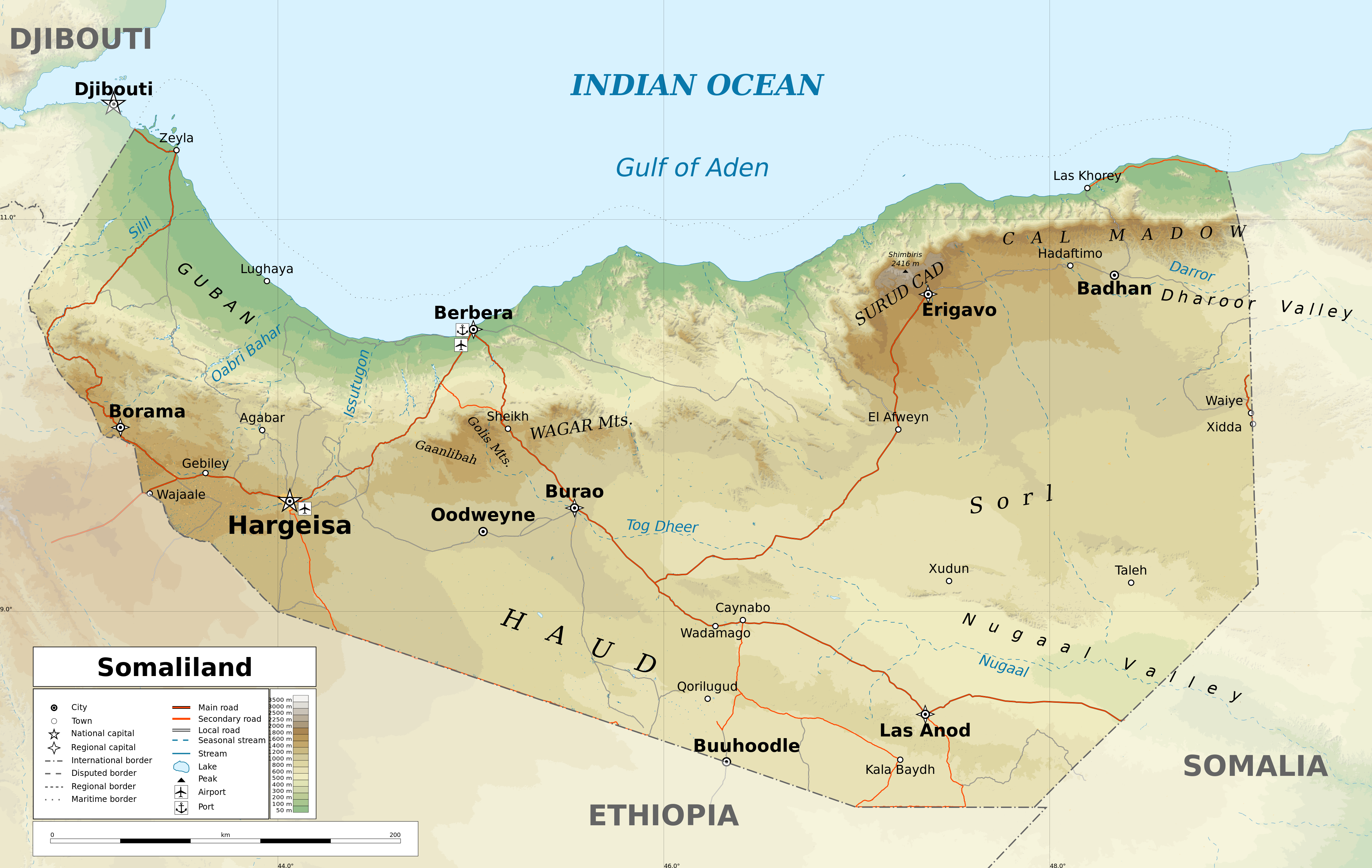
English: Geographic map of Somaliland. Geographic limits of the map:
|
| 日期 | |
| 来源 |
自己的作品
|
| 作者 | Ikonact |
| 授权 (二次使用本文件) |
Any use of this map is subject of the license(s) stated below with the condition that you credit (Wikimedia Commons user: Ikonact) as the author . A message with a reply address would also be greatly appreciated. |
| 其他版本 |
[]
|
| SVG开发 |


评价
|
许可协议
我,本作品著作权人,特此采用以下许可协议发表本作品:
本文件采用知识共享署名-相同方式共享 4.0 国际许可协议授权。
- 您可以自由地:
- 共享 – 复制、发行并传播本作品
- 修改 – 改编作品
- 惟须遵守下列条件:
- 署名 – 您必须对作品进行署名,提供授权条款的链接,并说明是否对原始内容进行了更改。您可以用任何合理的方式来署名,但不得以任何方式表明许可人认可您或您的使用。
- 相同方式共享 – 如果您再混合、转换或者基于本作品进行创作,您必须以与原先许可协议相同或相兼容的许可协议分发您贡献的作品。
文件历史
点击某个日期/时间查看对应时刻的文件。
| 日期/时间 | 缩略图 | 大小 | 用户 | 备注 | |
|---|---|---|---|---|---|
| 当前 | 2022年2月13日 (日) 17:20 | | 4,110 × 2,600(11.09 MB) | Jacob300 | Reverted to version as of 22:29, 26 August 2021 (UTC) |
| 2021年8月27日 (五) 08:01 |  | 4,110 × 2,600(11.27 MB) | Ikonact | Reverted to version as of 11:59, 26 August 2021 (UTC) - the eastern border is disputed and should stay as such | |
| 2021年8月26日 (四) 22:29 |  | 4,110 × 2,600(11.09 MB) | Siirski | Corrected eastern border | |
| 2021年8月26日 (四) 11:59 |  | 4,110 × 2,600(11.27 MB) | Ikonact | final touch | |
| 2021年8月26日 (四) 09:37 |  | 4,110 × 2,600(11.36 MB) | Ikonact | legend, names in En | |
| 2021年8月25日 (三) 20:47 |  | 4,110 × 2,600(11.33 MB) | Ikonact | + mnts nammes | |
| 2021年8月25日 (三) 20:07 |  | 4,110 × 2,600(11.32 MB) | Ikonact | font | |
| 2021年8月25日 (三) 20:03 |  | 4,110 × 2,600(11.32 MB) | Ikonact | more data | |
| 2021年8月24日 (二) 12:56 |  | 4,110 × 2,600(16.17 MB) | Ikonact | == {{int:filedesc}} == {{Information |description={{en|Geographic map of {{W|Somaliland}}. Geographic limits of the map:}} *N: 12.12° N *S: 7.69° N *W: 42.56° E *E: 49.67° E Equidistant Cylindrical projection; WGS 84 datum |date=2021-08-24 |source={{own}} *Sources of data:<br/> **Topography: SRTM3 v4 (public domain);<br/> **Rivers and water bodies: Natural Earth, © OpenStreetMap contributors **Borders and towns: © OpenStreetMap contributors;<br/> *Tool:<br/> **The map is created with Octave s... |
文件用途
以下2个页面使用本文件:
全域文件用途
以下其他wiki使用此文件:
- ar.wikipedia.org上的用途
- bg.wikipedia.org上的用途
- ca.wikipedia.org上的用途
- da.wikipedia.org上的用途
- de.wikipedia.org上的用途
- en.wikipedia.org上的用途
- fr.wikipedia.org上的用途
- ga.wikipedia.org上的用途
- gl.wikipedia.org上的用途
- hu.wikipedia.org上的用途
- id.wikipedia.org上的用途
- is.wikipedia.org上的用途
- ja.wikipedia.org上的用途
- ku.wikipedia.org上的用途
- lt.wikipedia.org上的用途
- ru.wikivoyage.org上的用途
- sh.wikipedia.org上的用途
- so.wikipedia.org上的用途
- sv.wikipedia.org上的用途
- www.wikidata.org上的用途