File:Germanic tribes (750BC-1AD).png
此为最大尺寸。
Germanic_tribes_(750BC-1AD).png (537 × 376像素,文件大小:10 KB,MIME类型:image/png)
.png?uselang=zh)
.png?uselang=zh)
.png?action=history&uselang=zh)
.png)
摘要

|
File:Germanic tribes settlements 750BC-1AD.svg是此文件的矢量版本。 如果此文件质量不低于原点阵图,就应该将这个PNG格式文件替换为此文件。
File:Germanic tribes (750BC-1AD).png → File:Germanic tribes settlements 750BC-1AD.svg
更多信息请参阅Help:SVG/zh。 |
 |
| 描述 |
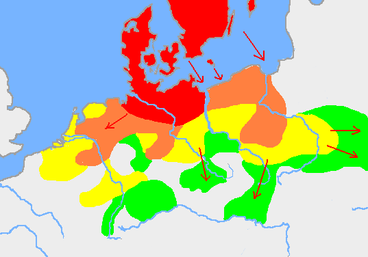
English: Based on p. 108 in the Penguin Atlas of World History, volume 1, from the Beginning to the Eve of the French Revolution. 1988. ISBN 0-14-051054-0. Note that the map assumes that the Nordwestblock was Germanized before 500 BC. This is uncertain; alternative proposals hold that the area near the mouths of the Rhine came under a Germanic superstate only in the 1st century BC.
The map is drawn on en:User:Dbachmann's blank map: en:Image:Europe plain rivers.png Settlements before 750 bc
New settlements by 500 bc
New settlements by 250 bc
New settlements by ad 1
Archived copy of a version of the original map. |
| 日期 | 2007年1月21日 (原始上传日期) |
| 来源 | 本檔案是從en.wikipedia轉移到維基共享資源。 |
| 作者 | 英语维基百科的Berig |
see also Image:Pre Migration Age Germanic.png
许可协议
I, Berig,本作品著作权人,特此采用以下许可协议发表本作品:

|
已授权您依据自由软件基金会发行的无固定段落及封面封底文字(Invariant Sections, Front-Cover Texts, and Back-Cover Texts)的GNU自由文件许可协议1.2版或任意后续版本的条款,复制、传播和/或修改本文件。该协议的副本请见“GNU Free Documentation License”。 |
| 本文件采用知识共享署名-相同方式共享 3.0 未本地化版本许可协议授权。 | ||
| 署名: I, Berig | ||
| ||
| 本许可协议标签作为GFDL许可协议更新的组成部分被添加至本文件。 |
您可以选择您需要的许可协议。
原始上传日志
原始描述頁面位於這裡。下列使用者名稱均來自en.wikipedia。
- 2007-01-21 10:52 Berig 537×376×8 (18448 bytes) Based on p. 108 in the Penguin Atlas of World History, volume 1, from the Beginning to the Eve of the French Revolution. 1988. The map is drawn on [[User:Dbachmann]]'s blank map: [[:Image:Europe plain rivers.png]]
文件历史
点击某个日期/时间查看对应时刻的文件。
| 日期/时间 | 缩略图 | 大小 | 用户 | 备注 | |
|---|---|---|---|---|---|
| 当前 | 2009年2月17日 (二) 00:34 | | 537 × 376(10 KB) | Disposable.Heroes | pngcrush |
| 2007年3月11日 (日) 17:17 |  | 537 × 376(18 KB) | R9tgokunks | {{Information |Description=Based on p. 108 in the Penguin Atlas of World History, volume 1, from the Beginning to the Eve of the French Revolution. 1988. ISBN 0-14-051054-0 The map is drawn on en:User:Dbachmann's blank map: [[:en::Image:Europe plain | |
| 2007年2月11日 (日) 20:17 |  | 537 × 376(18 KB) | Electionworld | {{Information |Description=Based on p. 108 in the Penguin Atlas of World History, volume 1, from the Beginning to the Eve of the French Revolution. 1988. ISBN 0-14-051054-0 The map is drawn on en:User:Dbachmann's blank map: [[:en::Image:Europe plain |
文件用途
全域文件用途
以下其他wiki使用此文件:
- af.wikipedia.org上的用途
- ar.wikipedia.org上的用途
- ast.wikipedia.org上的用途
- av.wikipedia.org上的用途
- azb.wikipedia.org上的用途
- bg.wikipedia.org上的用途
- bn.wikipedia.org上的用途
- bs.wikipedia.org上的用途
- ca.wikipedia.org上的用途
- ckb.wikipedia.org上的用途
- cv.wikipedia.org上的用途
- de.wikipedia.org上的用途
- el.wikipedia.org上的用途
- en.wikipedia.org上的用途
- Bastarnae
- Celts
- Germanic languages
- Germanic peoples
- History of Germany
- History of the Netherlands
- Lombards
- AD 1
- 250 BC
- Marchian
- Eastphalian language
- Proto-Germanic language
- Ruhrdeutsch
- East Germanic languages
- Talk:Germania
- Benrath line
- Lexin
- Vadstena bracteate
- Svealand dialects
- Leew Eilun Feer
- South Franconian German
- Highest Alemannic German
- Moselle Franconian language
- Stellingwarfs dialect
查看本文件的更多全域用途。
.png)
.png)