File:Germany, Federal Republic of location map January 1957 - October 1990.svg

此SVG文件的PNG预览的大小:506 × 599像素。 其他分辨率:203 × 240像素 | 405 × 480像素 | 648 × 768像素 | 865 × 1,024像素 | 1,729 × 2,048像素 | 1,075 × 1,273像素。
原始文件 (SVG文件,尺寸为1,075 × 1,273像素,文件大小:490 KB)
摘要
| 描述 |
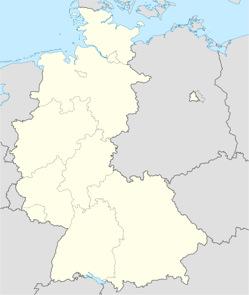
Deutsch: Positionskarte der Bundesrepublik Deutschland. Diese Karte zeigt die Bundesrepublik im Gebietsstand zwischen Januar 1957 bis Oktober 1990.
Quadratische Plattkarte, N-S-Streckung 150 %. Geographische Begrenzung der Karte:
English: Location map of Federal Republic of Germany. Map shows West-Germany as of January 1957 till October 1990.
Equirectangular projection, N/S stretching 150 %. Geographic limits of the map:
|
||
| 日期 | Created in 2009 | ||
| 来源 | own work, based on File:Germany location map.svg | ||
| 作者 | TUBS | ||
| 授权 (二次使用本文件) |
我,本作品著作权人,特此采用以下许可协议发表本作品:
本文件采用知识共享署名-相同方式共享 3.0 未本地化版本许可协议授权。
您可以选择您需要的许可协议。 |
||
| 其他版本 |
此文件衍生的作品: Bundesrepublik Deutschland (vor 1990 nur West-Deutschland):
Deutsche Demokratische Republik (mit BRD im Ausschnitt):
Ostdeutschland (vor 1990 Deutsche Demokratische Republik):
Deutschland zwischen Mai 1945 und Oktober 1949:
Thematisch:
Deutsches Reich (1918–1945) (best used with this template (de)):
|


_23_May_1949_-_6_Oct_1949.svg)


_location_map.svg)
_location_map_2013.svg)


.svg&action=edit&redlink=1)
.svg)
文件历史
点击某个日期/时间查看对应时刻的文件。
| 日期/时间 | 缩略图 | 大小 | 用户 | 备注 | |
|---|---|---|---|---|---|
| 当前 | 2013年9月16日 (一) 14:53 | | 1,075 × 1,273(490 KB) | NordNordWest | Reverted to version as of 08:36, 16 September 2013; your are destroying the location map function of this map |
| 2013年9月16日 (一) 12:46 |  | 927 × 1,274(673 KB) | SokoWiki | Berlin was not part of the Federal Republic of Germany until 1990. | |
| 2013年9月16日 (一) 08:36 |  | 1,075 × 1,273(490 KB) | NordNordWest | Reverted to version as of 22:14, 15 September 2013 | |
| 2013年9月15日 (日) 22:39 |  | 927 × 1,274(673 KB) | SokoWiki | Reverted to version as of 20:04, 15 September 2013 | |
| 2013年9月15日 (日) 22:14 |  | 1,075 × 1,273(490 KB) | TUBS | Reverted to version as of 03:25, 18 January 2009 | |
| 2013年9月15日 (日) 20:04 |  | 927 × 1,274(673 KB) | SokoWiki | * | |
| 2009年1月18日 (日) 03:25 |  | 1,075 × 1,273(490 KB) | TUBS | {{Information |Description=Germany,_Federal_Republic_of__location_map_April_1952_-_August_1955 |Source=own work |Date=2009 |Author=Author:TUBS |Permission= |other_versions= }} <!--{{ImageUpload|basic}}--> |
文件用途
以下38个页面使用本文件:
- 1963年至1964年德国足球甲级联赛
- 1964年至1965年德国足球甲级联赛
- 1965年至1966年德国足球甲级联赛
- 1966年至1967年德国足球甲级联赛
- 1967年至1968年德国足球甲级联赛
- 1968年至1969年德国足球甲级联赛
- 1969年至1970年德国足球甲级联赛
- 1970年至1971年德国足球甲级联赛
- 1971年至1972年德国足球甲级联赛
- 1972年夏季奥林匹克运动会
- 1972年夏季帕拉林匹克運動會
- 1972年至1973年德国足球甲级联赛
- 1973年至1974年德国足球甲级联赛
- 1974年國際足協世界盃
- 1974年至1975年德国足球甲级联赛
- 1975年至1976年德国足球甲级联赛
- 1976年至1977年德国足球甲级联赛
- 1977年至1978年德国足球甲级联赛
- 1978年至1979年德国足球甲级联赛
- 1979年至1980年德国足球甲级联赛
- 1980年至1981年德国足球甲级联赛
- 1981年至1982年德国足球甲级联赛
- 1982年至1983年德国足球甲级联赛
- 1983年至1984年德国足球甲级联赛
- 1984年至1985年德国足球甲级联赛
- 1985年至1986年德国足球甲级联赛
- 1986年至1987年德国足球甲级联赛
- 1987年至1988年德国足球甲级联赛
- 1988年欧洲足球锦标赛
- 1988年至1989年德国足球甲级联赛
- 1989年夏季世界大學運動會
- 1989年至1990年德国足球甲级联赛
- 1990年至1991年德国足球甲级联赛
- 國際足協世界盃場館列表
- 德國舊聯邦州
- Template:Location map FRG and West Berlin
- Module:Location map/data/FRG and West Berlin
- Module:Location map/data/FRG and West Berlin/doc
全域文件用途
以下其他wiki使用此文件:
- af.wikipedia.org上的用途
- als.wikipedia.org上的用途
- ar.wikipedia.org上的用途
- az.wikipedia.org上的用途
- ban.wikipedia.org上的用途
- bn.wikipedia.org上的用途
- ১৯৬৩–৬৪ বুন্দেসলিগা
- ১৯৬৪–৬৫ বুন্দেসলিগা
- ১৯৬৫–৬৬ বুন্দেসলিগা
- ১৯৬৬–৬৭ বুন্দেসলিগা
- ১৯৬৭–৬৮ বুন্দেসলিগা
- ১৯৬৮–৬৯ বুন্দেসলিগা
- ১৯৬৯–৭০ বুন্দেসলিগা
- ১৯৭০–৭১ বুন্দেসলিগা
- ১৯৭১–৭২ বুন্দেসলিগা
- ১৯৭২–৭৩ বুন্দেসলিগা
- ১৯৭৩–৭৪ বুন্দেসলিগা
- ১৯৭৪–৭৫ বুন্দেসলিগা
- ১৯৭৫–৭৬ বুন্দেসলিগা
- ১৯৭৬–৭৭ বুন্দেসলিগা
- ১৯৭৭–৭৮ বুন্দেসলিগা
- ১৯৭৮–৭৯ বুন্দেসলিগা
- ১৯৭৯–৮০ বুন্দেসলিগা
- ১৯৮০–৮১ বুন্দেসলিগা
- ১৯৮১–৮২ বুন্দেসলিগা
- ১৯৮২–৮৩ বুন্দেসলিগা
- ১৯৮৩–৮৪ বুন্দেসলিগা
- ১৯৮৪–৮৫ বুন্দেসলিগা
- ১৯৮৫–৮৬ বুন্দেসলিগা
- ১৯৮৬–৮৭ বুন্দেসলিগা
- ১৯৮৭–৮৮ বুন্দেসলিগা
- ১৯৮৮–৮৯ বুন্দেসলিগা
- ১৯৮৯–৯০ বুন্দেসলিগা
- ১৯৯০–৯১ বুন্দেসলিগা
查看本文件的更多全域用途。