File:Gettysburg Day2 Wheatfield1.png
本预览的尺寸:800 × 600像素。 其他分辨率:320 × 240像素 | 640 × 480像素 | 1,024 × 768像素 | 1,280 × 960像素 | 2,560 × 1,920像素 | 4,800 × 3,600像素。
原始文件 (4,800 × 3,600像素,文件大小:9.56 MB,MIME类型:image/png)
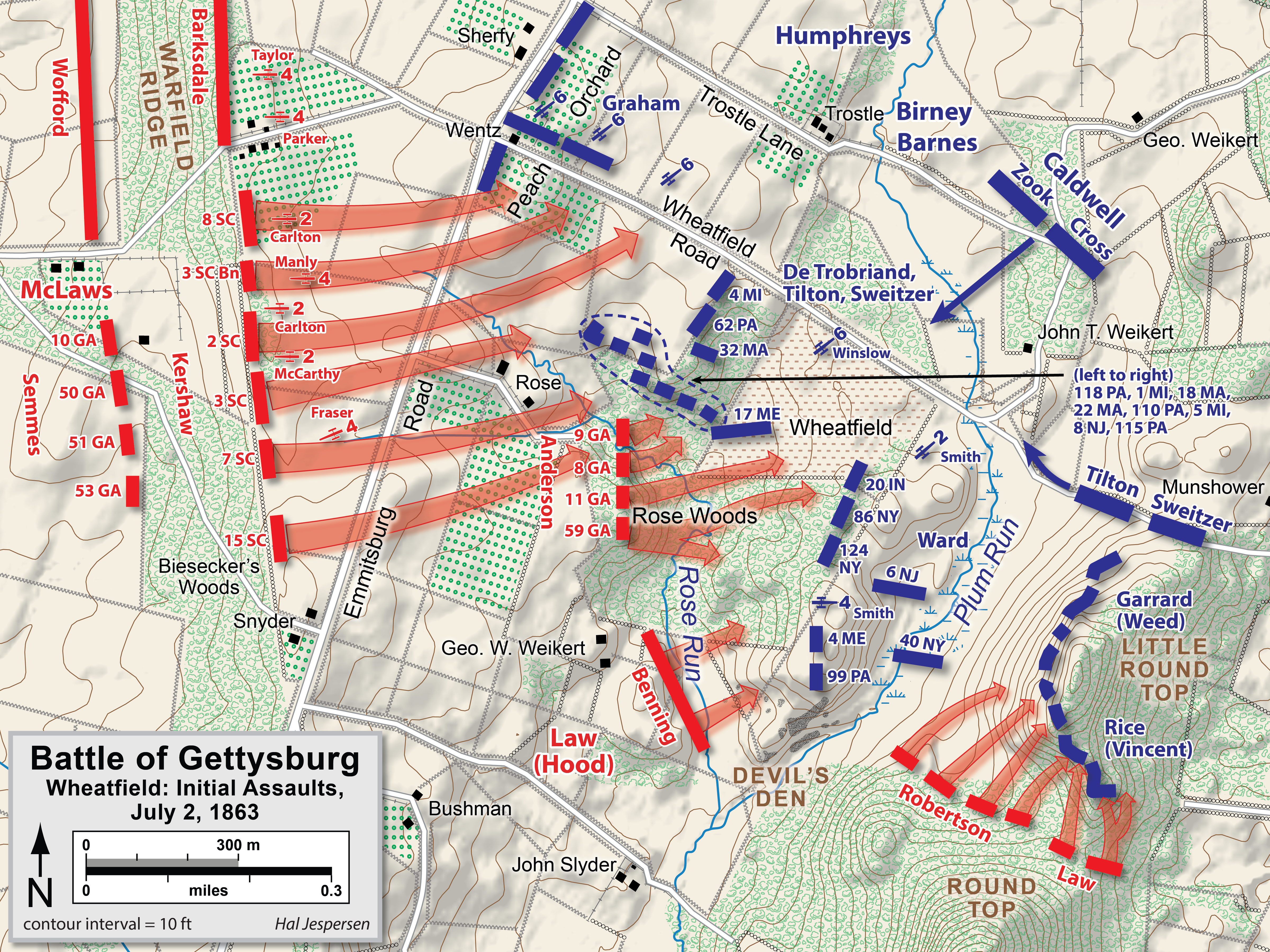
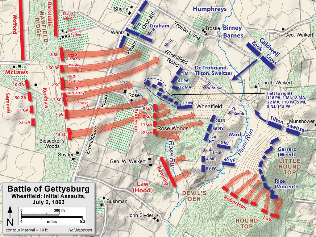
| 描述 | Map of Wheatfield actions in the Battle of Gettysburg, Second Day, of the American Civil War. Updated unit positions and made topographical background consistent with many other Wikipedia Gettysburg maps. Drawn in Adobe Illustrator CS5 by Hal Jespersen. Graphic source file is available at http://www.posix.com/CWmaps/ |
| 日期 | |
| 来源 | 自己的作品 |
| 作者 | Hal Jespersen |
本文件采用知识共享署名 3.0 未本地化版本许可协议授权。
署名: Map by Hal Jespersen, www.posix.com/CW
- 您可以自由地:
- 共享 – 复制、发行并传播本作品
- 修改 – 改编作品
- 惟须遵守下列条件:
- 署名 – 您必须对作品进行署名,提供授权条款的链接,并说明是否对原始内容进行了更改。您可以用任何合理的方式来署名,但不得以任何方式表明许可人认可您或您的使用。
文件历史
点击某个日期/时间查看对应时刻的文件。
| 日期/时间 | 缩略图 | 大小 | 用户 | 备注 | |
|---|---|---|---|---|---|
| 当前 | 2023年2月3日 (五) 17:39 | | 4,800 × 3,600(9.56 MB) | Hlj | improved graphics and detail |
| 2011年4月2日 (六) 20:03 |  | 2,449 × 1,789(1.21 MB) | Hlj | Updated graphical format of rivers and roads. Same license. | |
| 2010年7月31日 (六) 00:04 |  | 2,449 × 1,789(1.17 MB) | Hlj | New version improves accuracy of unit positions and graphic style that matches others in the Gettysburg series. Added legend box. Drawn by Hal Jespersen in Adobe Illustrator CS5. Graphic source file is available at http://www.posix.com/CWmaps/ {{cc-by-3.0 | |
| 2010年7月10日 (六) 18:33 |  | 2,449 × 1,789(1.17 MB) | Hlj | {{Information |Description=Map of Little Round Top (Battle of Gettysburg) of the American Civil War. Updated unit positions and made topographical background consistent with many other Wikipedia Gettysburg maps. Drawn in Adobe Illustrator CS5 by Hal J | |
| 2006年11月16日 (四) 14:15 |  | 1,483 × 1,203(510 KB) | Rheo1905~commonswiki | This map is made by en:User:Hlj. 1863. 7. 2. Gettysburg Second Day, Battle of Wheatfield (1) {{PD-release}} |
文件用途
以下页面使用本文件:
全域文件用途
以下其他wiki使用此文件:
- cs.wikipedia.org上的用途
- da.wikipedia.org上的用途
- en.wikipedia.org上的用途
- hu.wikipedia.org上的用途
- ko.wikipedia.org上的用途
- ru.wikipedia.org上的用途