File:Gulf of Tonkin location.gif
此为最大尺寸。
Gulf_of_Tonkin_location.gif (500 × 500像素,文件大小:90 KB,MIME类型:image/gif)

|
此locator map图片可使用矢量图形重新创建为SVG文件。这具有很多好处;更多信息请参见共享资源:待清理媒体。如果存在此图片的SVG格式,请将其上传,然后将此模板替换为
{{vector version available|新图片名称}}。
建议您将SVG命名为“Gulf of Tonkin location.svg”,这样在使用Vector version available(或Vva)模板时就不需要填写新图片名称参数。 |
| 描述 |
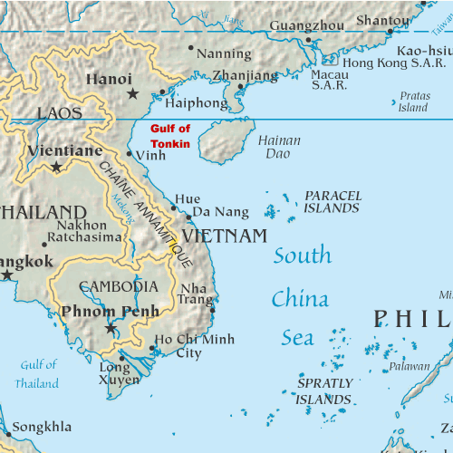
English: Map showing the location of the Gulf of Tonkin in the South China Sea |
||
| 日期 | 2005年10月31日 (原始上传日期) | ||
| 来源 | My original artwork based on a public domain map from the CIA World Factbook. | ||
| 作者 | 原上传者为英语维基百科的DanMS | ||
| 授权 (二次使用本文件) |
|
原始上传日志
原始描述頁面位於這裡。下列使用者名稱均來自en.wikipedia。
- 2005-11-02 16:39 DanMS 500×500× (92188 bytes) Map showing the location of the Gulf of Tonkin in the South China Sea. My original artwork based on a public domain map from the CIA World Factbook. This is a modification of my earlier file by the same name. {{pd-user|DanMS}}
- 2005-10-31 21:55 DanMS 500×500× (89358 bytes) Map showing the location of the Gulf of Tonkin in the South China Sea. My original artwork based on a public domain map from the CIA World Factbook. {{pd-user|DanMS}}
文件历史
点击某个日期/时间查看对应时刻的文件。
| 日期/时间 | 缩略图 | 大小 | 用户 | 备注 | |
|---|---|---|---|---|---|
| 当前 | 2010年5月15日 (六) 11:29 | | 500 × 500(90 KB) | Urdangaray | {{Information |Description={{en|Map showing the location of the Gulf of Tonkin in the South China Sea. My original artwork based on a public domain map from the CIA World Factbook.}} |Source=Transferred from [http://en.wikipedia.org en.wikipedia] |Date={{ |
文件用途
以下页面使用本文件:
全域文件用途
以下其他wiki使用此文件:
- af.wikipedia.org上的用途
- ar.wikipedia.org上的用途
- bg.wikipedia.org上的用途
- bn.wikipedia.org上的用途
- bs.wikipedia.org上的用途
- cs.wikipedia.org上的用途
- cy.wikipedia.org上的用途
- de.wikipedia.org上的用途
- en.wikipedia.org上的用途
- es.wikipedia.org上的用途
- fa.wikipedia.org上的用途
- fi.wikipedia.org上的用途
- fr.wikipedia.org上的用途
- fy.wikipedia.org上的用途
- he.wikipedia.org上的用途
- hi.wikipedia.org上的用途
- hu.wikipedia.org上的用途
- id.wikipedia.org上的用途
- ilo.wikipedia.org上的用途
- it.wikipedia.org上的用途
- ja.wikipedia.org上的用途
- km.wikipedia.org上的用途
- ky.wikipedia.org上的用途
- mk.wikipedia.org上的用途
- nds-nl.wikipedia.org上的用途
- nl.wikipedia.org上的用途
- nn.wikipedia.org上的用途
- pl.wikipedia.org上的用途
- sh.wikipedia.org上的用途
- sl.wikipedia.org上的用途
- sr.wikipedia.org上的用途
- th.wikipedia.org上的用途
- ur.wikipedia.org上的用途
- vi.wikipedia.org上的用途
- war.wikipedia.org上的用途