File:Historic Triangle Virginia.jpg
本预览的尺寸:800 × 532像素。 其他分辨率:320 × 213像素 | 640 × 426像素 | 1,024 × 681像素 | 1,280 × 851像素 | 2,923 × 1,944像素。
原始文件 (2,923 × 1,944像素,文件大小:526 KB,MIME类型:image/jpeg)
摘要

|
此road map图片可使用矢量图形重新创建为SVG文件。这具有很多好处;更多信息请参见共享资源:待清理媒体。如果存在此图片的SVG格式,请将其上传,然后将此模板替换为
{{vector version available|新图片名称}}。
建议您将SVG命名为“Historic Triangle Virginia.svg”,这样在使用Vector version available(或Vva)模板时就不需要填写新图片名称参数。 |


| 描述 |
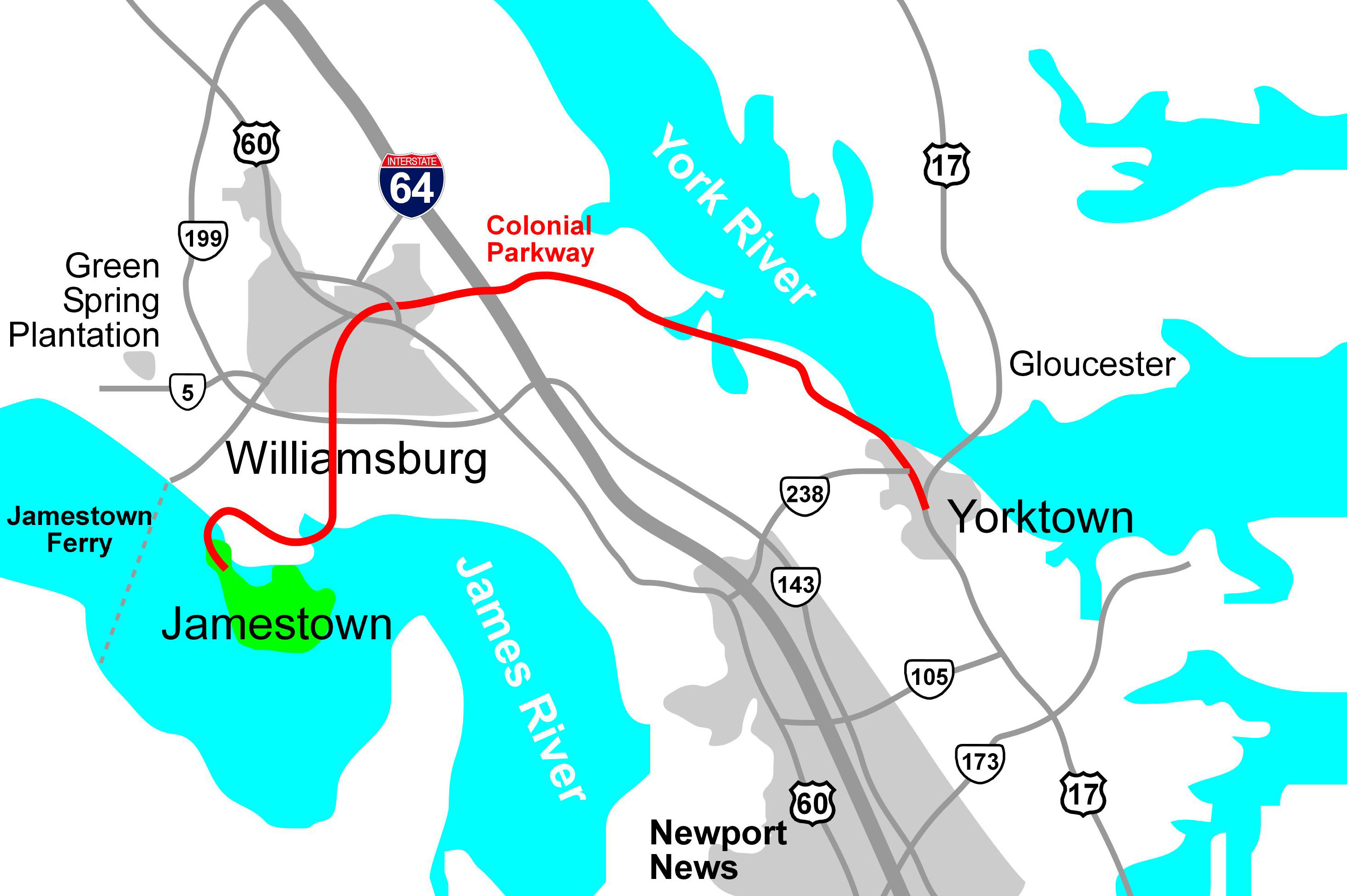
English: Map of the Colonial Parkway, a National Scenic Byway within Colonial National Historical Park in Virginia, drawn in Macromedia Freehand. |
| 日期 | 2006年1月30日 (原始上传日期) |
| 来源 | Derived from source file available in http://posix.com/CWmaps, although it is about today's Virginia, not the Civil War |
| 作者 | Hal Jespersen at en.wikipedia |
| 授权 (二次使用本文件) |
Released into the public domain (by the author). |
| 其他版本 | File:Historic Triangle Virginia PNG.png |
许可协议
| |
本作品已被作者中文维基百科项目的Hal Jespersen释出到公有领域。这适用于全世界。 如果这样做不合法的话: |
原始上传日志
原始描述頁面位於這裡。下列使用者名稱均來自en.wikipedia。
- 2006-01-30 22:25 Hlj 2923×1944× (538422 bytes) Updated the image to correct the location of Green Spring Plantation.
- 2005-10-19 15:50 Hlj 2824×1933× (492287 bytes) Drawn by Hal Jespersen in Macromedia Freehand. Source file available in http://posix.com/CWmaps (although it is about modern Virginia, not the Civil War).
文件历史
点击某个日期/时间查看对应时刻的文件。
| 日期/时间 | 缩略图 | 大小 | 用户 | 备注 | |
|---|---|---|---|---|---|
| 当前 | 2010年1月24日 (日) 15:22 | | 2,923 × 1,944(526 KB) | BotMultichill | {{BotMoveToCommons|en.wikipedia|year={{subst:CURRENTYEAR}}|month={{subst:CURRENTMONTHNAME}}|day={{subst:CURRENTDAY}}}} {{Information |Description={{en|Drawn by Hal Jespersen in Macromedia Freehand. Source file available in http://posix.com/CWmaps (altho |
文件用途
以下页面使用本文件:
全域文件用途
以下其他wiki使用此文件:
- en.wikipedia.org上的用途
- es.wikipedia.org上的用途
- www.wikidata.org上的用途