File:Hudson bay explorer.png
此为最大尺寸。
Hudson_bay_explorer.png (550 × 442像素,文件大小:449 KB,MIME类型:image/png)
| 描述 |
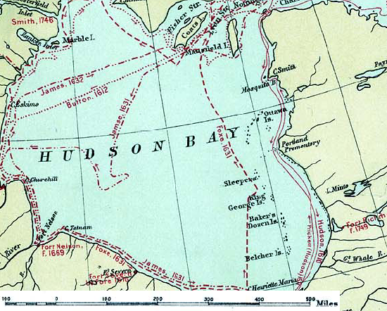
English: Map of the routes of the main European explorers in Hudson Bay, Canada. |
|||||
| 日期 | ||||||
| 来源 | Excerpted from 1st Edition, 1906, Atlas of Canada - Routes of Explorers,1497 to 1905. | |||||
| 作者 | Department of the Interior, Ottawa | |||||
| 授权 (二次使用本文件) |
Crown copyright expired.
|

原始上传日志
原始描述頁面位於這裡。下列使用者名稱均來自en.wikipedia。
- 2007-01-26 22:28 CyclePat 550×442×8 (459278 bytes) ==Description== This map shows the routes followed by the principal explorers of what is now Canada, from 1497 up to 1905. The map also shows the location of forts with the date of their establishment. It was created using [[:image:Canada, Routes of Explo
文件历史
点击某个日期/时间查看对应时刻的文件。
| 日期/时间 | 缩略图 | 大小 | 用户 | 备注 | |
|---|---|---|---|---|---|
| 当前 | 2008年7月10日 (四) 11:41 | | 550 × 442(449 KB) | Urdangaray | {{Information |Description={{en|thumb|400px|right|Canada, Routes of Explorers,1497 to 1905 This map shows the routes followed by the principal explorers of what is now Canada, from 1497 up to 190 |
文件用途
以下页面使用本文件:
全域文件用途
以下其他wiki使用此文件:
- ast.wikipedia.org上的用途
- az.wikipedia.org上的用途
- bg.wikipedia.org上的用途
- ca.wikipedia.org上的用途
- cv.wikipedia.org上的用途
- de.wikipedia.org上的用途
- en.wikipedia.org上的用途
- es.wikipedia.org上的用途
- hi.wikipedia.org上的用途
- nn.wikipedia.org上的用途
- ru.wikipedia.org上的用途