File:International E Road Network green.png

本预览的尺寸:800 × 571像素。 其他分辨率:320 × 229像素 | 640 × 457像素。
原始文件 (840 × 600像素,文件大小:38 KB,MIME类型:image/png)

|
此road map图片可使用矢量图形重新创建为SVG文件。这具有很多好处;更多信息请参见共享资源:待清理媒体。如果存在此图片的SVG格式,请将其上传,然后将此模板替换为
{{vector version available|新图片名称}}。
建议您将SVG命名为“International E Road Network green.svg”,这样在使用Vector version available(或Vva)模板时就不需要填写新图片名称参数。 |
摘要
| 描述 |
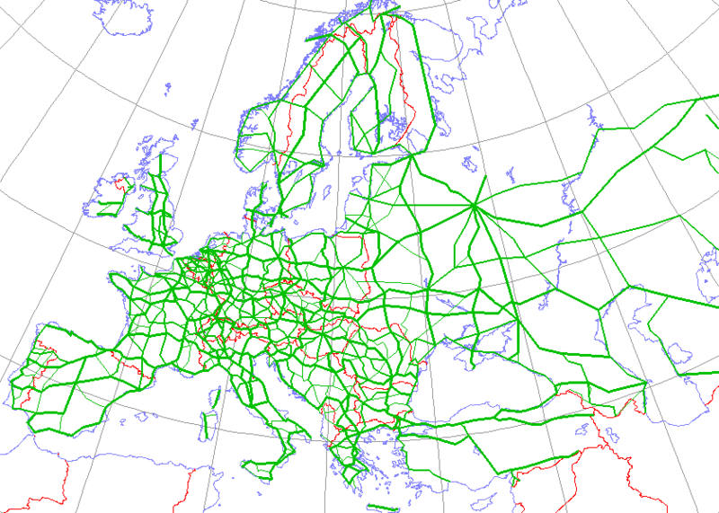
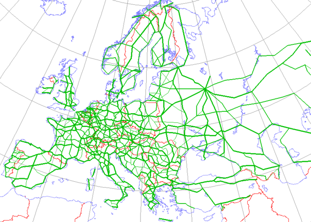
English: Map generated using coastline/boundary data from World Data Bank, and locations from http://www.world-gazetteer.com/. Straight lines connect control cities, no attempt to follow the real road. Roads color has been changed to green.
Deutsch: Diese Karte wurde mit den Küsten- und Grenzverlaufsdaten aus der World Data Bank und mit den Koordinaten aus http://www.world-gazetteer.com/ erstellt. Die Städte sind durch gerade Linien vebunden die nicht unbedingt den realen Straßenverlauf wiedergeben. Die Farbe der Straßen wurde in grün geändert.
Türkçe: Harita oluşturulken sahilyolu ve sınırlar bilgisi Dünya Bilgi Bankası'ndan ve lokasyonlar http://www.world-gazetteer.com/ adlı siteden alınmıştır. Düz çizgiler kontrol şehirlerini bağlar. Yol rengi yeşile değiştirildi. |
| 来源 | http://en.wikipedia.org/wiki/Image:International_E_Road_Network.png |
| 作者 | Kjhskj75 |
许可协议
| 我,本作品著作权人,释出本作品至公有领域。这适用于全世界。 在一些国家这可能不合法;如果是这样的话,那么: 我无条件地授予任何人以任何目的使用本作品的权利,除非这些条件是法律规定所必需的。 |
文件历史
点击某个日期/时间查看对应时刻的文件。
| 日期/时间 | 缩略图 | 大小 | 用户 | 备注 | |
|---|---|---|---|---|---|
| 当前 | 2008年5月13日 (二) 16:09 | | 840 × 600(38 KB) | Jklamo | Albania update |
| 2007年12月22日 (六) 12:07 |  | 840 × 600(39 KB) | BIL | == Description == {{Information |Description=Map generated using coastline/boundary data from World Data Bank, and locations from www.world-gazetteer.com. Straight lines connect control cities, no attempt to follow the real road. Roads color has been chan | |
| 2007年10月7日 (日) 20:03 |  | 840 × 600(33 KB) | The RedBurn | All e-roads in green. | |
| 2007年10月7日 (日) 19:55 |  | 840 × 600(34 KB) | The RedBurn | {{Information |Description=Map generated using coastline/boundary data from World Data Bank, and locations from www.world-gazetteer.com. Straight lines connect control cities, no attempt to follow the real road. Roads color has been changed to green. |Sou |
文件用途
以下85个页面使用本文件:
- 欧洲E012公路
- 欧洲E019公路
- 欧洲E101公路
- 欧洲E10公路
- 欧洲E11公路
- 欧洲E12公路
- 欧洲E13公路
- 欧洲E14公路
- 欧洲E15公路
- 欧洲E16公路
- 欧洲E17公路
- 欧洲E18公路
- 欧洲E19公路
- 欧洲E1公路
- 欧洲E20公路
- 欧洲E21公路
- 欧洲E22公路
- 欧洲E23公路
- 欧洲E24公路
- 欧洲E25公路
- 欧洲E26公路
- 欧洲E27公路
- 欧洲E28公路
- 欧洲E29公路
- 欧洲E30公路
- 欧洲E31公路
- 欧洲E32公路
- 欧洲E33公路
- 欧洲E34公路
- 欧洲E35公路
- 欧洲E36公路
- 欧洲E373公路
- 欧洲E37公路
- 欧洲E38公路
- 欧洲E39公路
- 欧洲E3公路
- 欧洲E40公路
- 欧洲E41公路
- 欧洲E42公路
- 欧洲E43公路
- 欧洲E44公路
- 欧洲E45公路
- 欧洲E46公路
- 欧洲E47公路
- 欧洲E48公路
- 欧洲E4公路
- 欧洲E50公路
- 欧洲E52公路
- 欧洲E53公路
- 欧洲E54公路
- 欧洲E55公路
- 欧洲E57公路
- 欧洲E59公路
- 欧洲E5公路
- 欧洲E60公路
- 欧洲E61公路
- 欧洲E65公路
- 欧洲E67公路
- 欧洲E69公路
- 欧洲E6公路
- 欧洲E70公路
- 欧洲E71公路
- 欧洲E73公路
- 欧洲E75公路
- 欧洲E761公路
- 欧洲E763公路
- 欧洲E77公路
- 欧洲E79公路
- 欧洲E7公路
- 欧洲E80公路
- 欧洲E81公路
- 欧洲E83公路
- 欧洲E85公路
- 欧洲E87公路
- 欧洲E89公路
- 欧洲E8公路
- 欧洲E90公路
- 欧洲E97公路
- 欧洲E99公路
- 欧洲E9公路
- 欧洲高速公路
- 歐洲E49公路
- 歐洲E51公路
- 歐洲E63公路
- Template:欧洲国际公路网
全域文件用途
以下其他wiki使用此文件:
- ar.wikipedia.org上的用途
- be.wikipedia.org上的用途
- bg.wikipedia.org上的用途
- Европейски път
- Европейски път Е79
- Европейски път Е70
- Европейски път Е80
- Европейски път Е67
- Европейски път Е85
- Европейски път Е851
- Европейски път Е671
- Шаблон:Европейска пътна мрежа
- Европейски път Е81
- Европейски път Е804
- Европейски път Е763
- Европейски път Е762
- Европейски път Е87
- Европейски път Е772
- Европейски път Е83
- Европейски път Е871
- Европейски път Е75
- Европейски път Е773
- Европейски път Е11
- Европейски път Е51
- Европейски път Е761
- Европейски път Е17
- Европейски път Е76
- Европейски път Е82
- Европейски път Е84
- Европейски път Е86
- Европейски път E01
- Европейски път E03
- Европейски път E04
- Европейски път E05
- Европейски път E06
- Европейски път E07
- Европейски път E08
- Европейски път E09
- Европейски път E10
- Европейски път E12
- Европейски път E13
- Европейски път E14
查看本文件的更多全域用途。