File:Joint Security Area 1976 map.jpg

本预览的尺寸:676 × 599像素。 其他分辨率:271 × 240像素 | 541 × 480像素 | 758 × 672像素。
原始文件 (758 × 672像素,文件大小:96 KB,MIME类型:image/jpeg)
摘要
| 描述 |
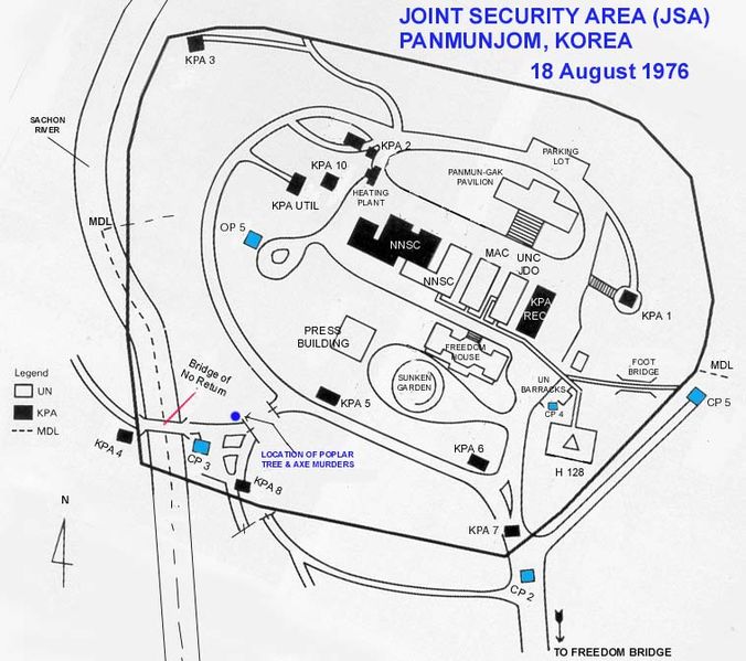
English: A map showing the layout (and names) of the various buildings within the Joint Security Area.
Legend: CP - Check Point KPA - Korean People's Army MAC - Military Armistice Commission MDL - Military Demarcation Line NNSC - Neutral Nations Supervisory Commission OP - Observation Post UNC - United Nations Command |
| 日期 |
|
| 来源 | Transferred from en.wikipedia by SreeBot |
| 作者 | Wbfergus at en.wikipedia |
许可协议
此作品在美国属于公有领域,因为其是由美国政府的官员或雇员,基于其个人公务目的制作的作品,参考美国法典第17篇第1章第105条。
注意︰本模板仅适用于美国联邦政府的原创作品,不适用于任何美国州、属地、联邦个体、县、市或任何次级政府的作品。本模板也不适用于1978年以后由美国邮政署出版的邮票图案(参看美国版权局实践纲领第313.6(C)(1)条)。也不适用于部分美国硬币;参看美国铸币局使用条款。 |
 | |
| 本文件已被确认为免除已知的著作权法限制(包括所有相关权利)。 | ||
原始上传日志
原始描述頁面位於這裡。下列使用者名稱均來自en.wikipedia。
Upload date | User | Bytes | Dimensions | Comment
- 2006-11-27 19:40 (UTC) | Wbfergus | 98352 (bytes) | 758×672 | A map showing the layout (and names) of the various buildings within the Joint Security Area.
文件历史
点击某个日期/时间查看对应时刻的文件。
| 日期/时间 | 缩略图 | 大小 | 用户 | 备注 | |
|---|---|---|---|---|---|
| 当前 | 2011年8月5日 (五) 21:24 | | 758 × 672(96 KB) | SreeBot |
文件用途
全域文件用途
以下其他wiki使用此文件:
- ar.wikipedia.org上的用途
- de.wikipedia.org上的用途
- en.wikipedia.org上的用途
- es.wikipedia.org上的用途
- fr.wikipedia.org上的用途
- it.wikipedia.org上的用途
- ko.wikipedia.org上的用途
- nl.wikipedia.org上的用途
- ru.wikipedia.org上的用途
- sv.wikipedia.org上的用途