File:Kaurnaland.png
此为最大尺寸。
Kaurnaland.png (444 × 499像素,文件大小:52 KB,MIME类型:image/png)
摘要
| 描述 |
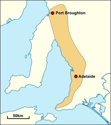
English: Approximate extent of the traditional territory of the Kaurna people. Based on the description given by Robert Amery in Warrabarna Kaurna!: reclaiming an Australian language. |
| 日期 | |
| 来源 | 基于如下对象的个人作品: Australia South Australia location map.svg |
| 作者 | Yeti Hunter (talk) |
许可协议
英语维基百科的Yeti Hunter,本作品著作权人,特此采用以下许可协议发表本作品:
本文件采用知识共享署名-相同方式共享 3.0 未本地化版本许可协议授权。
署名: 英语维基百科的Yeti Hunter
- 您可以自由地:
- 共享 – 复制、发行并传播本作品
- 修改 – 改编作品
- 惟须遵守下列条件:
- 署名 – 您必须对作品进行署名,提供授权条款的链接,并说明是否对原始内容进行了更改。您可以用任何合理的方式来署名,但不得以任何方式表明许可人认可您或您的使用。
- 相同方式共享 – 如果您再混合、转换或者基于本作品进行创作,您必须以与原先许可协议相同或相兼容的许可协议分发您贡献的作品。

|
已授权您依据自由软件基金会发行的无固定段落及封面封底文字(Invariant Sections, Front-Cover Texts, and Back-Cover Texts)的GNU自由文件许可协议1.2版或任意后续版本的条款,复制、传播和/或修改本文件。该协议的副本请见“GNU Free Documentation License”。 |
您可以选择您需要的许可协议。
原始上传日志
原始描述頁面位於這裡。下列使用者名稱均來自en.wikipedia。
- 2010-01-15 07:41 Yeti Hunter 444×499× (53150 bytes) Shading some islands that I missed first time
- 2010-01-15 06:19 Yeti Hunter 444×499× (54451 bytes) Fixing map - adding Kangaroo Island
- 2010-01-15 06:11 Yeti Hunter 444×499× (48515 bytes) {{Information |Description = Approximate extent of the traditional territory of the Kaurna people. Based on the description given by Robert Amery in ''Warrabarna Kaurna!: reclaiming an Australian language''. Map based on [[File:Australia South Austral
文件历史
点击某个日期/时间查看对应时刻的文件。
| 日期/时间 | 缩略图 | 大小 | 用户 | 备注 | |
|---|---|---|---|---|---|
| 当前 | 2019年5月5日 (日) 15:57 | | 444 × 499(52 KB) | OgreBot | (BOT): Uploading old version of file from en.wikipedia; originally uploaded on 2010-01-15 07:41:28 by Yeti Hunter |
| 2019年5月5日 (日) 15:57 |  | 444 × 499(53 KB) | OgreBot | (BOT): Uploading old version of file from en.wikipedia; originally uploaded on 2010-01-15 06:19:33 by Yeti Hunter | |
| 2019年5月5日 (日) 15:57 |  | 444 × 499(47 KB) | OgreBot | (BOT): Uploading old version of file from en.wikipedia; originally uploaded on 2010-01-15 06:11:21 by Yeti Hunter |
文件用途
以下页面使用本文件:
全域文件用途
以下其他wiki使用此文件: