File:Knowledge of French EU map.svg

此SVG文件的PNG预览的大小:585 × 599像素。 其他分辨率:234 × 240像素 | 468 × 480像素 | 749 × 768像素 | 999 × 1,024像素 | 1,999 × 2,048像素 | 1,212 × 1,242像素。
原始文件 (SVG文件,尺寸为1,212 × 1,242像素,文件大小:549 KB)
摘要
| 描述 |
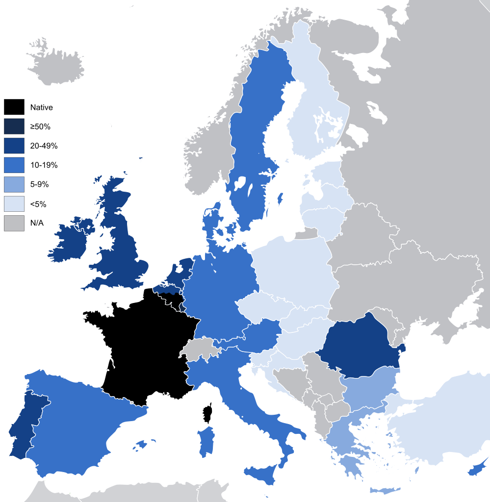
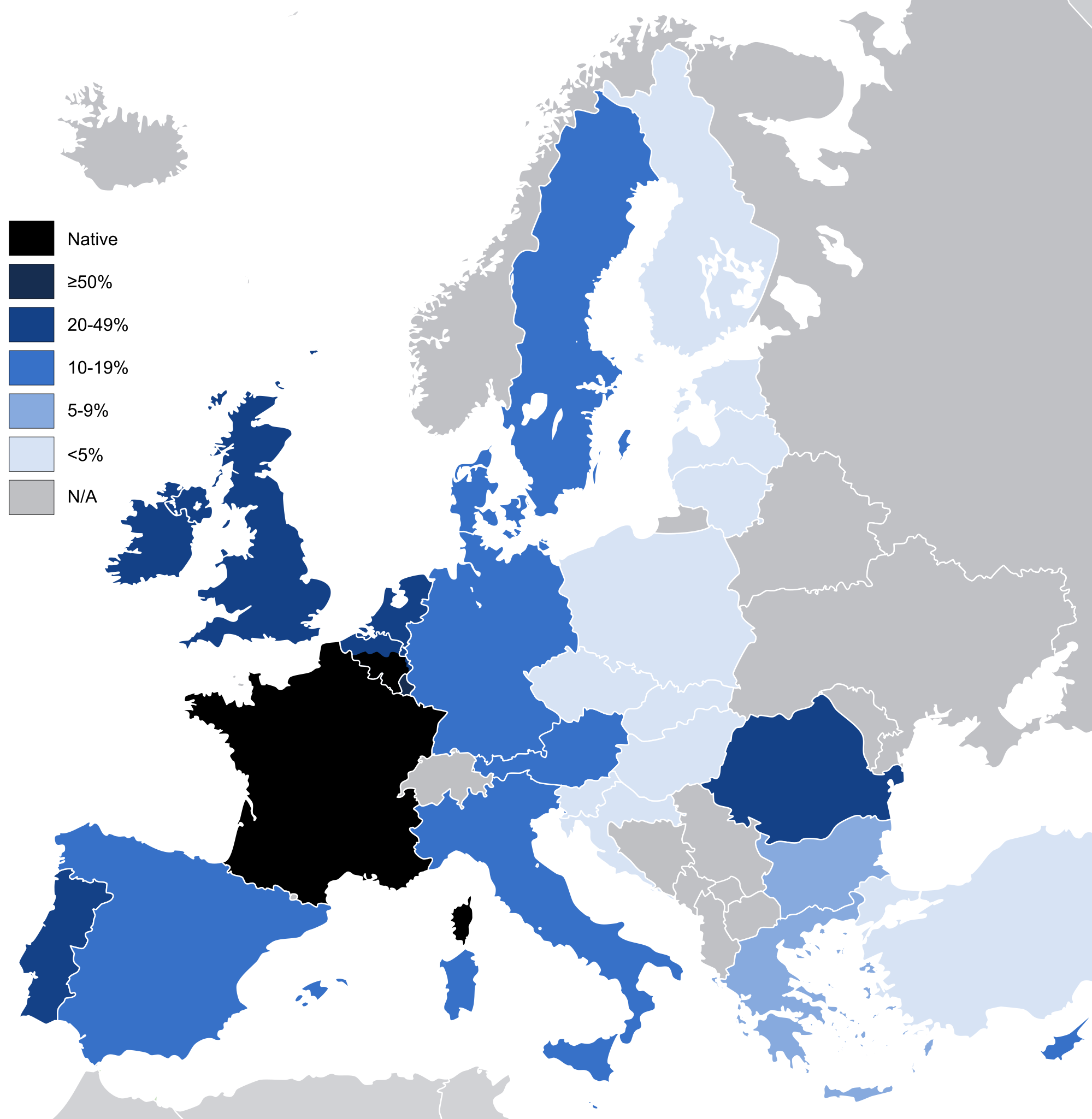
English: Knowledge French to a conversational level (other than as a mother tongue) in the European Union and the United Kingdom, according to: "Special Eurobarometer 243" of the European Commission with the title "Europeans and their Languages" [1]
|
| 日期 | |
| 来源 | Image:EU27-2008 European Union map.svg |
| 作者 | Addicted04 |
| 其他版本 |
|

许可协议
| 我,本作品著作权人,释出本作品至公有领域。这适用于全世界。 在一些国家这可能不合法;如果是这样的话,那么: 我无条件地授予任何人以任何目的使用本作品的权利,除非这些条件是法律规定所必需的。 |
文件历史
点击某个日期/时间查看对应时刻的文件。
| 日期/时间 | 缩略图 | 大小 | 用户 | 备注 | |
|---|---|---|---|---|---|
| 当前 | 2021年6月14日 (一) 06:42 | | 1,212 × 1,242(549 KB) | Sbb1413 | Reverted to version as of 02:02, 3 January 2012 (UTC) Reverting to include the knowledge of French in the UK, despite no longer being part of the EU. Rewording the filedesc. |
| 2020年2月3日 (一) 10:50 |  | 1,212 × 1,242(550 KB) | Darranc | Remove UK from EU | |
| 2012年1月3日 (二) 02:02 |  | 1,212 × 1,242(549 KB) | Fenn-O-maniC | Added Wallonia | |
| 2011年3月6日 (日) 18:51 |  | 1,212 × 1,242(546 KB) | Alphathon | Fixed Swedish lakes | |
| 2011年3月6日 (日) 18:43 |  | 1,212 × 1,242(540 KB) | Alphathon | Added >5% category | |
| 2010年8月28日 (六) 20:45 |  | 1,212 × 1,242(517 KB) | Alphathon | Key borders and Irish lakes added | |
| 2010年8月27日 (五) 14:15 |  | 1,212 × 1,242(514 KB) | Alphathon | Cropped etc. for consistency with other, similar maps | |
| 2009年10月17日 (六) 18:27 |  | 680 × 520(518 KB) | Addicted04 | map | |
| 2008年11月27日 (四) 16:09 |  | 1,218 × 1,245(2 KB) | SammyV~commonswiki | {{Information |Description={{en|1=Knowledge French in the European Union, according to: "Special Eurobarometer 243" of the European Commission with the title "Europeans and their Languages" }} |Source=Own work by uploader |Author=SammyV |D |
文件用途
全域文件用途
以下其他wiki使用此文件:
- ar.wikipedia.org上的用途
- ast.wikipedia.org上的用途
- ba.wikipedia.org上的用途
- bg.wikipedia.org上的用途
- bs.wikipedia.org上的用途
- de.wikipedia.org上的用途
- el.wikipedia.org上的用途
- en.wikipedia.org上的用途
- eo.wikipedia.org上的用途
- es.wikipedia.org上的用途
- fa.wikipedia.org上的用途
- fi.wikipedia.org上的用途
- fr.wikipedia.org上的用途
- ga.wikipedia.org上的用途
- gd.wiktionary.org上的用途
- gl.wikipedia.org上的用途
- he.wikipedia.org上的用途
- hu.wikipedia.org上的用途
- id.wikipedia.org上的用途
- incubator.wikimedia.org上的用途
- is.wikipedia.org上的用途
- ja.wikipedia.org上的用途
- kbp.wikipedia.org上的用途
- kk.wikipedia.org上的用途
- kk.wikibooks.org上的用途
- lez.wikipedia.org上的用途
- lfn.wikipedia.org上的用途
- lmo.wikipedia.org上的用途
- nl.wikipedia.org上的用途
- olo.wikipedia.org上的用途
- pcd.wikipedia.org上的用途
- pfl.wikipedia.org上的用途
- pl.wikipedia.org上的用途
- pnb.wikipedia.org上的用途
- ro.wikipedia.org上的用途
查看本文件的更多全域用途。