File:Ladysmith Town Hall 1900 - Project Gutenberg eText 15972.png
Ladysmith_Town_Hall_1900_-_Project_Gutenberg_eText_15972.png (550 × 380像素,文件大小:36 KB,MIME类型:image/png)
摘要
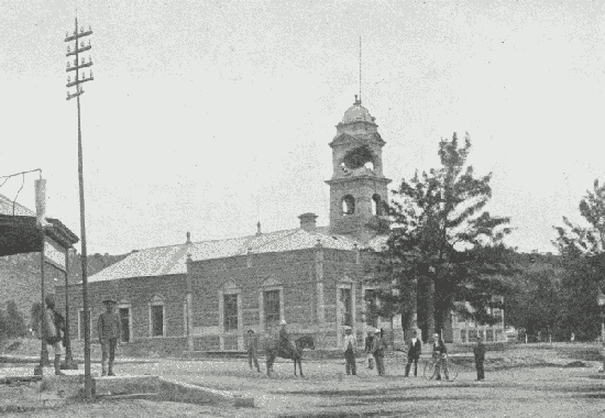
| This media shows a South African Protected Site with SAHRA file reference 9/2/415/0027 See also: External entry in South African Heritage Resource Agency database. |
| 相机位置 | | 在以下服务上查看本图像和附近其他图像: OpenStreetMap |
|---|
Ladysmith Town hall 1900 during the Siege of Ladysmith
From http://www.gutenberg.org/etext/15972
许可协议
| This image comes from the Project Gutenberg archives. This is an image that has come from a book or document for which the American copyright has expired and this image is in the public domain in the United States and possibly other countries.
This eBook is for the use of anyone anywhere at no cost and with almost no restrictions whatsoever. You may copy it, give it away or re-use it under the terms of the Project Gutenberg License included with this eBook or online at www.gutenberg.net. |
文件历史
点击某个日期/时间查看对应时刻的文件。
| 日期/时间 | 缩略图 | 大小 | 用户 | 备注 | |
|---|---|---|---|---|---|
| 当前 | 2005年10月15日 (六) 19:35 | | 550 × 380(36 KB) | Tagishsimon | Ladysmith Town hall 1900 during the Siege of Ladysmith From http://www.gutenberg.org/etext/15972 |
文件用途
以下页面使用本文件:
全域文件用途
以下其他wiki使用此文件:
- de.wikipedia.org上的用途
- en.wikipedia.org上的用途
- en.wikivoyage.org上的用途
- es.wikipedia.org上的用途
- eu.wikipedia.org上的用途
- fi.wikipedia.org上的用途
- fr.wikipedia.org上的用途
- it.wikipedia.org上的用途
- ja.wikipedia.org上的用途
- no.wikipedia.org上的用途
- pl.wikipedia.org上的用途
- pt.wikipedia.org上的用途
- ru.wikipedia.org上的用途
- sv.wikipedia.org上的用途
- www.wikidata.org上的用途