File:Lake tana.jpg
本预览的尺寸:614 × 600像素。 其他分辨率:246 × 240像素 | 639 × 624像素。
原始文件 (639 × 624像素,文件大小:166 KB,MIME类型:image/jpeg)
摘要
| 描述 |
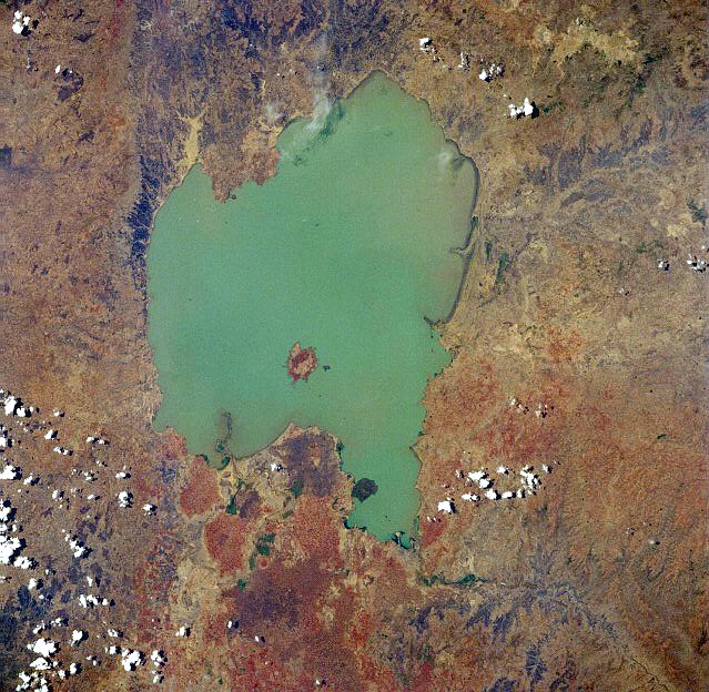
English: Lake Tana, Ethiopia - April 1991. Low-oblique, west-looking photograph (now after 270 degree rotation north-looking). Located in the central highlands of Ethiopia, Lake Tana, the country’s largest lake, covers 1400 square miles (3625 square kilometers). The lake is 47 miles (76 kilometers) long and 44 miles (71 kilometers) wide and sits at an elevation of 6000 feet (1830 meters) above sea level.
Ελληνικά: Δορυφορική φωτογραφία της Λίμνης Τάνα στην Αιθιοπία |
| 日期 | |
| 来源 | Image Science and Analysis Laboratory, NASA-Johnson Space Center, The Gateway to Astronaut Photography of Earth: STS037-84-3 |
| 作者 | NASA |
许可协议
| 本文件完全由NASA创作,在美国属于公有领域。根据NASA的版权方针,NASA的材料除非另有声明否则不受版权保护。(参见Template:PD-USGov/zh、NASA版权方针页面或JPL图片使用方针。) | ||
 |
警告:
|
文件历史
点击某个日期/时间查看对应时刻的文件。
| 日期/时间 | 缩略图 | 大小 | 用户 | 备注 | |
|---|---|---|---|---|---|
| 当前 | 2012年12月3日 (一) 07:45 | | 639 × 624(166 KB) | Rotatebot | Bot: Image rotated by 270° |
| 2005年8月13日 (六) 01:49 |  | 639 × 639(150 KB) | Boticario | Lake Tana, Ethiopia - April 1991 image description [http://eol.jsc.nasa.gov/sseop/EFS/photoinfo.pl?PHOTO=STS037-84-3 here] {{PD-USGov-NASA}} |
文件用途
以下页面使用本文件:
全域文件用途
以下其他wiki使用此文件:
- af.wikipedia.org上的用途
- ar.wikipedia.org上的用途
- azb.wikipedia.org上的用途
- az.wikipedia.org上的用途
- bn.wikipedia.org上的用途
- br.wikipedia.org上的用途
- ca.wikipedia.org上的用途
- ceb.wikipedia.org上的用途
- cs.wikipedia.org上的用途
- da.wikipedia.org上的用途
- de.wikipedia.org上的用途
- el.wikipedia.org上的用途
- en.wikipedia.org上的用途
- eo.wikipedia.org上的用途
- es.wikipedia.org上的用途
- fa.wikipedia.org上的用途
- fi.wikipedia.org上的用途
- fr.wikipedia.org上的用途
- gl.wikipedia.org上的用途
- he.wikipedia.org上的用途
- hr.wikipedia.org上的用途
- hu.wikipedia.org上的用途
- id.wikipedia.org上的用途
- is.wikipedia.org上的用途
- it.wikipedia.org上的用途
- ja.wikipedia.org上的用途
- ka.wikipedia.org上的用途
- kn.wikipedia.org上的用途
- ko.wikipedia.org上的用途
- ky.wikipedia.org上的用途
- la.wikipedia.org上的用途
- lv.wikipedia.org上的用途
- mk.wikipedia.org上的用途
- ml.wikipedia.org上的用途
- my.wikipedia.org上的用途
- nl.wikipedia.org上的用途
- no.wikipedia.org上的用途
- oc.wikipedia.org上的用途
- pnb.wikipedia.org上的用途
- pt.wikipedia.org上的用途
- ro.wikipedia.org上的用途
- sh.wikipedia.org上的用途
- sl.wikipedia.org上的用途
- sr.wikipedia.org上的用途
查看本文件的更多全域用途。