File:Land.ops.2.en.svg

此SVG文件的PNG预览的大小:800 × 581像素。 其他分辨率:320 × 233像素 | 640 × 465像素 | 1,024 × 744像素 | 1,280 × 930像素 | 2,560 × 1,860像素 | 940 × 683像素。
原始文件 (SVG文件,尺寸为940 × 683像素,文件大小:1.42 MB)

| 描述 |
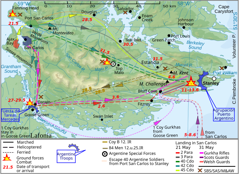
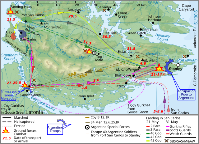
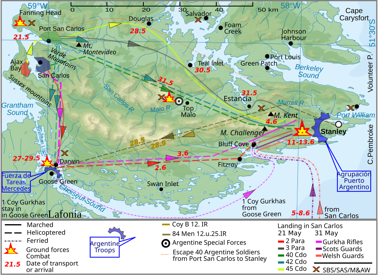
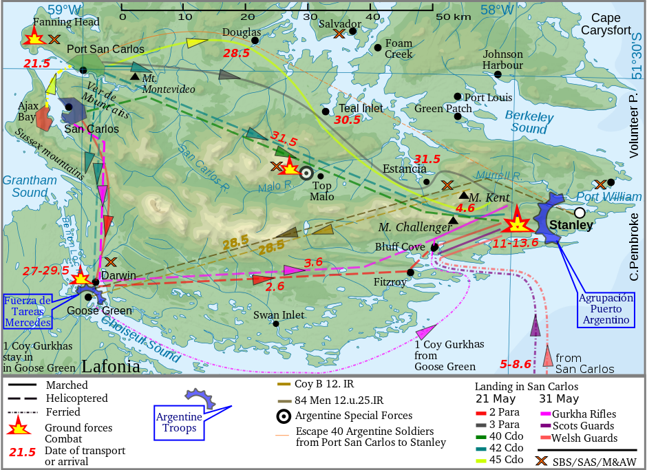
English: The Falkland Islands are an archipelago in the South Atlantic Ocean |
| 日期 | (UTC) |
| 来源 | |
| 作者 |
|
| 这是一张修改过的图片,这意味着它已在原版本的基础上通过软件进行了编辑。其原始版本为:Falkland Islands topographic map-en.svg。修改者: Createaccount。
|

|
已授权您依据自由软件基金会发行的无固定段落及封面封底文字(Invariant Sections, Front-Cover Texts, and Back-Cover Texts)的GNU自由文件许可协议1.2版或任意后续版本的条款,复制、传播和/或修改本文件。该协议的副本请见“GNU Free Documentation License”。 |
Uploaded with derivativeFX
文件历史
点击某个日期/时间查看对应时刻的文件。
| 日期/时间 | 缩略图 | 大小 | 用户 | 备注 | |
|---|---|---|---|---|---|
| 当前 | 2012年3月26日 (一) 10:40 | | 940 × 683(1.42 MB) | Brammers | Spelling change: Marsh > Marched |
| 2010年11月1日 (一) 19:47 |  | 940 × 683(1.42 MB) | Keysanger | {{Information |Description={{en|The '''Falkland Islands''' are an archipelago in the South Atlantic Ocean}} |Source=*File:Falkland_Islands_topographic_map-en.svg |Date=2010-11-01 19:44 (UTC) |Author=*[[:File:Falkland_Islands_topographic_map-en.s |
文件用途
以下页面使用本文件:
全域文件用途
以下其他wiki使用此文件:
- en.wikipedia.org上的用途
- fy.wikipedia.org上的用途
- he.wikipedia.org上的用途
- lt.wikipedia.org上的用途
- pl.wikipedia.org上的用途
- ro.wikipedia.org上的用途
- ru.wikipedia.org上的用途