File:MSH80 eruption mount st helens 05-18-80-dramatic-edit.jpg
本预览的尺寸:399 × 600像素。 其他分辨率:160 × 240像素 | 319 × 480像素 | 511 × 768像素 | 681 × 1,024像素 | 1,362 × 2,048像素 | 2,994 × 4,500像素。
原始文件 (2,994 × 4,500像素,文件大小:2.14 MB,MIME类型:image/jpeg)
| 描述 |
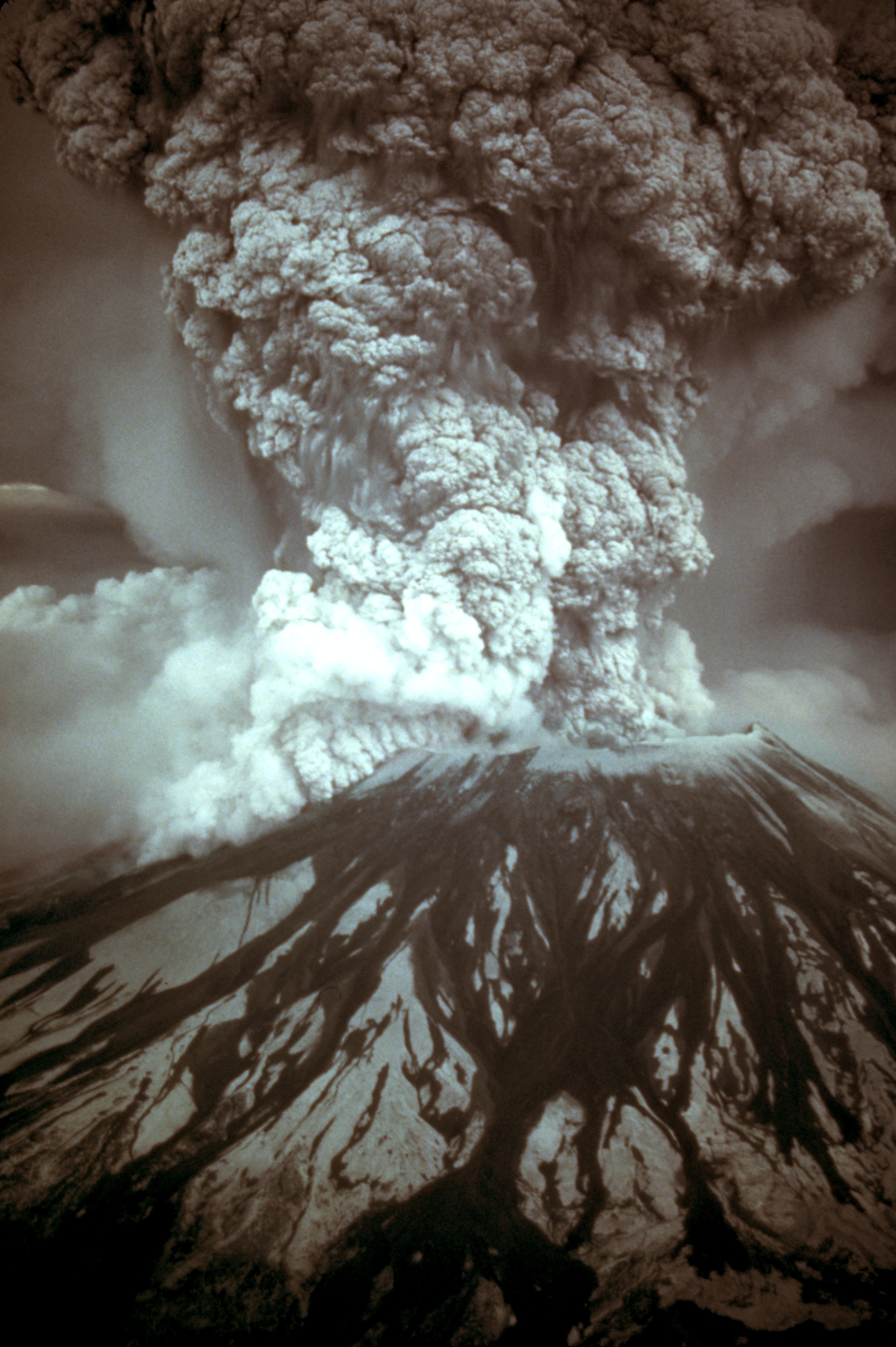
English: On May 18, 1980, at 8:32 a.m. Pacific Daylight Time, a magnitude 5.1 earthquake shook Mount St. Helens. The bulge and surrounding area slid away in a gigantic rockslide and debris avalanche, releasing pressure, and triggering a major pumice and ash eruption of the volcano. Thirteen-hundred feet (400 meters) of the peak collapsed or blew outwards. As a result, 24 square miles (62 square kilometers) of valley was filled by a debris avalanche, 250 square miles (650 square kilometers) of recreation, timber, and private lands were damaged by a lateral blast, and an estimated 200 million cubic yards (150 million cubic meters) of material was deposited directly by lahars (volcanic mudflows) into the river channels. Fifty-seven people were killed or are still missing.
USGS Photograph taken on May 18, 1980, by Austin Post.
Català: El 18 de maig, a les 8:32 a. m. Temps del Pacífic, un terratrèmol de una magnitud de 5,1 va fer trontollar la muntanya St. Helens. La protuberància l'àrea circumdant relliscà en una gegantina esllavissada de roques i un allau de rocam, alliberant la pressió, desencadenà una erupció de pedra tosca i cendra del volcà. 400 metres del puig van col·lapsar o van sortir volant. Com a resultat 62 quilometres quadrats de la vall van ser emplenats per la runa, 650 quilometres quadrats de llocs d'esbarjo, bosc, i finques privades van ser damnificades per una ràfega lateral, i una quantitat estimada en 150 milions de metres cúbics de material van ser dipositats per corrents de fang volcànic en els canals del riu. Cinquanta set persones van morir o han desaparegut (18 de Maig de 1980, Austin Post, USGS)
Español: Erupción del Monte Santa Helena el 18 de mayo de 1980. |
|||||||||||||
| 日期 | ||||||||||||||
| 来源 |
Huge tif converted to jpeg and caption from USGS Mount St. Helens, Washington May 18, 1980 Eruption Images |
|||||||||||||
| 作者 |
|
|||||||||||||
| 授权 (二次使用本文件) |
|
|||||||||||||
| 其他版本 |
 |
|||||||||||||
.jpg)
文件历史
点击某个日期/时间查看对应时刻的文件。
| 日期/时间 | 缩略图 | 大小 | 用户 | 备注 | |
|---|---|---|---|---|---|
| 当前 | 2007年11月28日 (三) 15:17 | | 2,994 × 4,500(2.14 MB) | CarolSpears | |
| 2007年11月28日 (三) 11:41 |  | 2,994 × 4,500(1.92 MB) | CarolSpears | {{Information |Description={{en|On May 18, 1980, at 8:32 a.m. Pacific Daylight Time, a magnitude 5.1 earthquake shook Mount St. Helens. The bulge and surrounding area slid away in a gigantic rockslide and debris avalanche, releasing pressure, and triggeri |
文件用途
以下9个页面使用本文件:
全域文件用途
以下其他wiki使用此文件:
- ar.wikipedia.org上的用途
- ast.wikipedia.org上的用途
- bg.wikipedia.org上的用途
- ca.wikipedia.org上的用途
- cs.wikipedia.org上的用途
- de.wikipedia.org上的用途
- el.wikipedia.org上的用途
- en.wikipedia.org上的用途
- 1980 eruption of Mount St. Helens
- May 1980
- Portal:Geology
- Talk:Mount St. Helens/Archive 2
- Template:Infobox eruption
- Template:Infobox eruption/doc
- Wikipedia:Featured picture candidates/Mount St. Helens eruption
- Wikipedia:Featured picture candidates/June-2013
- Timeline of Washington (state) history
- Portal:Washington (state)
- Template:Infobox eruption/sandbox
- en.wiktionary.org上的用途
- es.wikipedia.org上的用途
- fa.wikipedia.org上的用途
- fi.wikipedia.org上的用途
- fr.wikipedia.org上的用途
- hr.wikipedia.org上的用途
- hu.wikipedia.org上的用途
- it.wikipedia.org上的用途
- it.wikiquote.org上的用途
- ja.wikipedia.org上的用途
- km.wikipedia.org上的用途
- kn.wikipedia.org上的用途
- ko.wikipedia.org上的用途
查看本文件的更多全域用途。