File:Maharashtra Divisions Eng.svg

此SVG文件的PNG预览的大小:759 × 599像素。 其他分辨率:304 × 240像素 | 608 × 480像素 | 973 × 768像素 | 1,280 × 1,011像素 | 2,560 × 2,022像素 | 3,106 × 2,453像素。
原始文件 (SVG文件,尺寸为3,106 × 2,453像素,文件大小:289 KB)
摘要
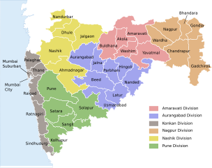
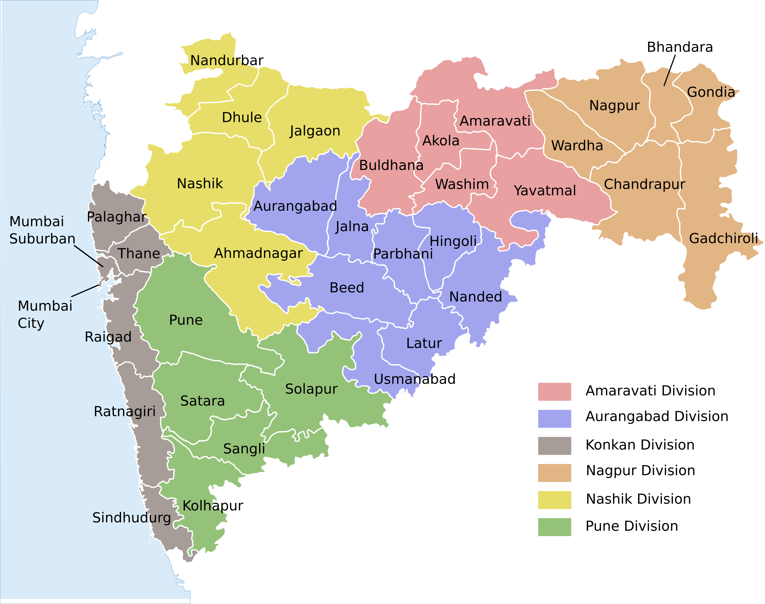
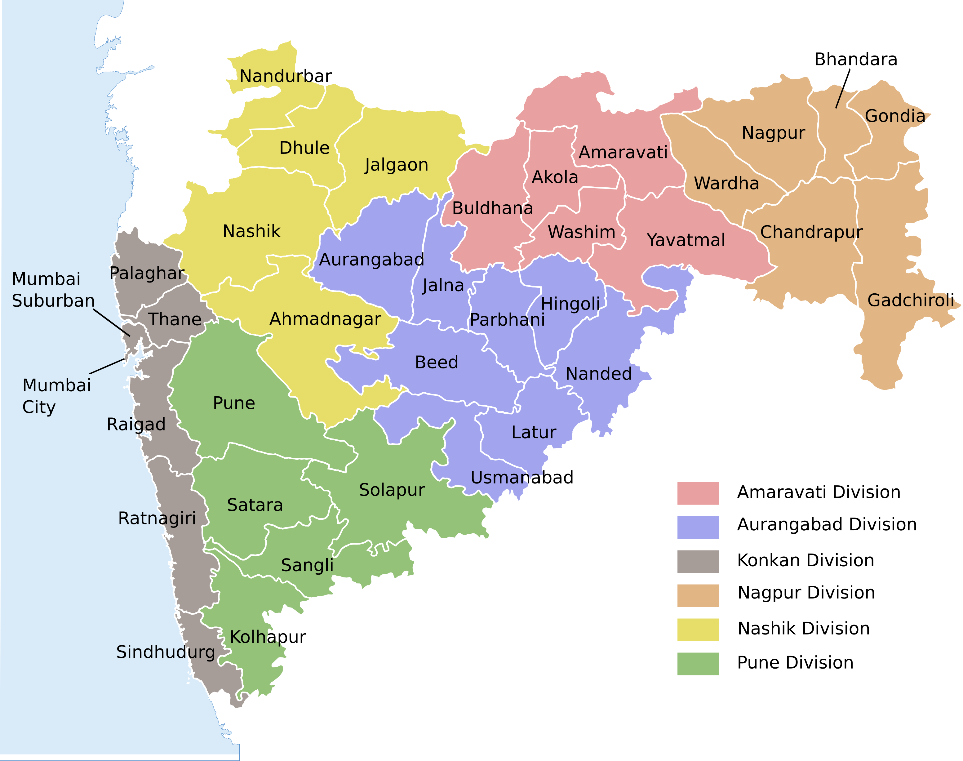
| 描述 | Locator map of the state of en:Maharashtra, India with district boundaries and Admin. divisions |
| 日期 | (UTC) |
| 来源 | |
| 作者 |
|
| 其他版本 |
[]
|


| 这是一张修改过的图片,这意味着它已在原版本的基础上通过软件进行了编辑,改动内容:Added colour coding & divisions。其原始版本为:Maharashtra locator map.svg。修改者: Kaajawa。
|
本文件采用知识共享署名-相同方式共享 3.0 未本地化版本许可协议授权。
- 您可以自由地:
- 共享 – 复制、发行并传播本作品
- 修改 – 改编作品
- 惟须遵守下列条件:
- 署名 – 您必须对作品进行署名,提供授权条款的链接,并说明是否对原始内容进行了更改。您可以用任何合理的方式来署名,但不得以任何方式表明许可人认可您或您的使用。
- 相同方式共享 – 如果您再混合、转换或者基于本作品进行创作,您必须以与原先许可协议相同或相兼容的许可协议分发您贡献的作品。
原始上传日志
This image is a derivative work of the following images:
- File:Maharashtra_locator_map.svg licensed with Cc-by-sa-3.0
- 2008-12-21T12:08:04Z Planemad 2789x2232 (365091 Bytes) {{Information |Description={{en|1=map}} |Source=Own work by uploader |Author=[[User:PlaneMad|PlaneMad]] |Date= |Permission= |other_versions= }}
Uploaded with derivativeFX
文件历史
点击某个日期/时间查看对应时刻的文件。
| 日期/时间 | 缩略图 | 大小 | 用户 | 备注 | |
|---|---|---|---|---|---|
| 当前 | 2020年8月15日 (六) 04:54 | | 3,106 × 2,453(289 KB) | শরদিন্দু ভট্টাচার্য্য | File uploaded using svgtranslate tool (https://svgtranslate.toolforge.org/). Added translation for bn. |
| 2020年8月3日 (一) 02:40 |  | 3,106 × 2,453(262 KB) | C1MM | Added Palaghar | |
| 2011年8月18日 (四) 16:09 |  | 3,106 × 2,453(248 KB) | Kaajawa | {{Information |Description=Locator map of the state of en:Maharashtra, India with district boundaries and Admin. divisions |Source=*File:Maharashtra_locator_map.svg |Date=2011-08-18 16:06 (UTC) |Author=*[[:File:Maharashtra_locator_m |
文件用途
以下2个页面使用本文件:
全域文件用途
以下其他wiki使用此文件:
- awa.wikipedia.org上的用途
- bh.wikipedia.org上的用途
- bn.wikipedia.org上的用途
- de.wikipedia.org上的用途
- dty.wikipedia.org上的用途
- en.wikipedia.org上的用途
- eu.wikipedia.org上的用途
- fi.wikipedia.org上的用途
- fr.wikipedia.org上的用途
- ha.wikipedia.org上的用途
- hi.wikipedia.org上的用途
- मुम्बई
- महाराष्ट्र
- पुणे
- नागपुर
- माथेरान
- मराठी भाषा
- विदर्भ
- अकोला
- नाशिक
- वर्धा
- अमरावती
- ठाणे
- जुन्नर तालुका
- जलगाँव
- अहमदनगर जिला
- अकोला जिला
- औरंगाबाद जिला, महाराष्ट्र
- अमरावती जिला
- बीड जिला
- भंडारा जिला
- बुलढाणा जिला
- चंद्रपुर जिला
- जालना जिला
- हिंगोली जिला
- गोंदिया जिला
- गढ़चिरौली जिला
- धुले जिला
- रायगढ़ जिला, महाराष्ट्र
- पुणे जिला
- परभणी जिला
- उस्मानाबाद जिला
- नाशिक जिला
- नंदुरबार जिला
查看本文件的更多全域用途。