File:Map of Gascon campaign of 1345.svg

此SVG文件的PNG预览的大小:552 × 599像素。 其他分辨率:221 × 240像素 | 442 × 480像素 | 708 × 768像素 | 943 × 1,024像素 | 1,887 × 2,048像素 | 914 × 992像素。
原始文件 (SVG文件,尺寸为914 × 992像素,文件大小:295 KB)
摘要
| 描述 |
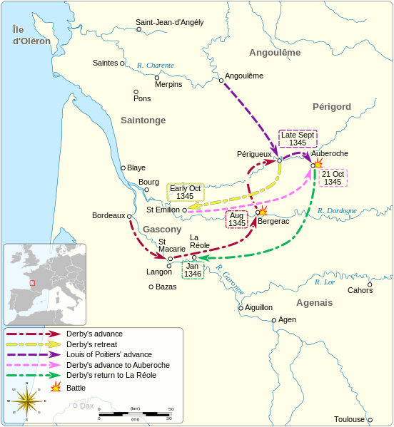
English: Map of the Gascon campaign of 1345, part of the Hundred Years' War. This map shows the English and French army movements during the campaign and the most important battles. Català: Mapa de la campanya gascona de 1345, part de la Guerra dels Cent Anys. Aquest mapa mostra els moviments de l'exèrcit anglès i francès durant la campanya i les batalles més importants.
|
||||||||||
| 日期 | |||||||||||
| 来源 |
自己的作品 Derived from; Information from:
|
||||||||||
| 作者 | Goran_tek-en | ||||||||||
| 授权 (二次使用本文件) |
本文件采用知识共享署名-相同方式共享 4.0 国际许可协议授权。 署名: Goran tek-en
|
||||||||||
| 其他版本 |
|
||||||||||
| SVG开发 | |||||||||||


| 物体位置 | | 在以下服务上查看本图像和附近其他图像: OpenStreetMap |
|---|


文件历史
点击某个日期/时间查看对应时刻的文件。
| 日期/时间 | 缩略图 | 大小 | 用户 | 备注 | |
|---|---|---|---|---|---|
| 当前 | 2023年10月2日 (一) 07:49 | | 914 × 992(295 KB) | Lalpino | File uploaded using svgtranslate tool (https://svgtranslate.toolforge.org/). Added translation for ca. |
| 2021年11月9日 (二) 19:53 |  | 914 × 992(224 KB) | Goran tek-en | View box, font size, color deficiency | |
| 2018年11月19日 (一) 17:56 |  | 914 × 993(128 KB) | Goran tek-en | {{Information |description ={{en|1=Map of the Gascon campaign of 1345, part of the Hundred Years' War. This map shows the English and French army movements during the campaign and the most important battles.}} |date = |source ={{Own}}<br> Derived from; * [https://www.openstreetmap.org/#map=8/44.678/-0.324 OSM] Information from: * [https://thehistoryofengland.co.uk/2013/09/29/104-lancaster-and-the-battle-of-auberoche/ The history of England] * {{U|Newm30}} |author... |
文件用途
以下2个页面使用本文件:
全域文件用途
以下其他wiki使用此文件:
- ca.wikipedia.org上的用途
- en.wikipedia.org上的用途
- fr.wikipedia.org上的用途
- hr.wikipedia.org上的用途
- it.wikipedia.org上的用途