File:Map of Pitcairn Islands 2.png
此为最大尺寸。
Map_of_Pitcairn_Islands_2.png (500 × 500像素,文件大小:8 KB,MIME类型:image/png)
摘要

许可协议

|
已授权您依据自由软件基金会发行的无固定段落及封面封底文字(Invariant Sections, Front-Cover Texts, and Back-Cover Texts)的GNU自由文件许可协议1.2版或任意后续版本的条款,复制、传播和/或修改本文件。该协议的副本请见“GNU Free Documentation License”。 |
原始上传日志
本檔案是由Magog the Ogre使用CommonsHelper,從en.wikipedia轉移到維基共享資源。
原始描述頁面位於這裡。下列使用者名稱均來自en.wikipedia。
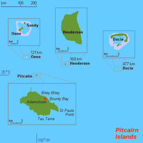
- 2011-07-06 22:17 Mixer 500×500× (8111 bytes) Original work by Hobe: ({{Information |Description={{en|1=Map of Pitcairn Islands (rough), Pacific Ocean, own work composed from various mapreferences}} |Source={{own}} |Author=Hobe / Holger Behr |Date=2010-04-25 |Permission= |other_versions= }} [[Categor
文件历史
点击某个日期/时间查看对应时刻的文件。
| 日期/时间 | 缩略图 | 大小 | 用户 | 备注 | |
|---|---|---|---|---|---|
| 当前 | 2012年10月9日 (二) 04:26 | | 500 × 500(8 KB) | File Upload Bot (Magnus Manske) | Transfered from en.wikipedia by User:Magog the Ogre using CommonsHelper |
文件用途
以下页面使用本文件:
全域文件用途
以下其他wiki使用此文件:
- ang.wikipedia.org上的用途
- ar.wikipedia.org上的用途
- arz.wikipedia.org上的用途
- ast.wikipedia.org上的用途
- ca.wikipedia.org上的用途
- cs.wikipedia.org上的用途
- de.wikipedia.org上的用途
- de.wikivoyage.org上的用途
- el.wikipedia.org上的用途
- en.wikipedia.org上的用途
- es.wikipedia.org上的用途
- eu.wikipedia.org上的用途
- fa.wikipedia.org上的用途
- gl.wikipedia.org上的用途
- he.wikipedia.org上的用途
- hu.wikipedia.org上的用途
- hy.wikipedia.org上的用途
- incubator.wikimedia.org上的用途
- ka.wikipedia.org上的用途
- lb.wikipedia.org上的用途
- mt.wikipedia.org上的用途
- ps.wikipedia.org上的用途
- pt.wikipedia.org上的用途
- ro.wikipedia.org上的用途
- ru.wikipedia.org上的用途
- sco.wikipedia.org上的用途
- sh.wikipedia.org上的用途
- sk.wikipedia.org上的用途
- sv.wikipedia.org上的用途
- tg.wikipedia.org上的用途
- tr.wikipedia.org上的用途
- ur.wikipedia.org上的用途
- www.wikidata.org上的用途