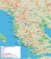
File:Map of ancient Epirus and environs (English).svg

原始文件(SVG文件,尺寸为1,303 × 1,500像素,文件大小:495 KB)


翻譯此檔案 此SVG檔案包含可翻譯至您的語言的内嵌文字,可以使用任何可用SVG編輯器、文本編輯器或SVG翻譯工具來翻譯。詳情請見:關於翻譯SVG檔案

摘要

描述
English: Map of ancient Epirus & Environs, Thracian, Illyrian, Paeonian, & Greek contact zones with illustration and extent of Hellenization up to the creation of Epirus Nova or Illyria Graeca
日期
来源 自己的作品
作者 MaryroseB54
其他版本

[编辑]

  • The classical age of Greece (1999),
  • ed. Atlas of the Greek and Roman world in antiquity (1981).
  • Hammond, N. G. L. A History of Greece to 322 B.C., 1986, ISBN-10: 0198730950
  • Wilkes, J. J. The Illyrians, 1992,ISBN 0631198075, (i.e. pages 174, 208, 210, 273)
  • In the Shadow of Olympus: The Emergence of Macedon,ISBN 0691008809,1992
  • Thracian Tribal areas (from Fol, Thrace and the Thracians, p 133),The Thracians 700 BC–AD 46 (Men-at-Arms 360) by Christopher Webber After Hoddinot, Col & Cah
  • Hendry, p. 299. The geography is entirely correct for Servius' time, since Diocletian's rearrangement of provincial boundaries included the creation of the province of Epirus Nova out of southern Illyricum with Dyrrachium (=Epidamnus) as its capital.
  • The Loeb Editor's Notes, 28 Nova Epirus or Illyris Graeca (Epirus, Nova Illyria Graeca) "Nova Epirus or Illyris Graeca extended from the Drilo (Mod. Drina) River on the north to the Ceraunian Mts. on the south, thus comprising a large part of modern Albania. Immediately to the south of it to the Ambracian Gulf (Mod. Gulf of Arta) lay what is here called Old Epirus, approximately identical with the Epirus of modern Greece."
  • Soustal, Peter; Koder, Johannes (1981). Tabula Imperii Byzantini, Band 3: Nikopolis und Kephallenia (in German). Vienna: Verlag der Osterreichischen Akademie der Wissenschaften. ISBN 3-7001-0399-9., page 47
  • A new classical dictionary of Greek and Roman biography, mythology, and geography: partly based upon the Dictionary of Greek and Roman biography and mythology by Sir William Smith,1851,page 392 "B. Illyris Graeca, which was called in later times Epirus Nova, extended from the river Drilo to the SE., up to the Ceraunian mountains, which separated it from Epirus Proper"
  • American journal of philology, Τόμοι 98-99,by JSTOR (Organization), Project Muse,1977,page 263, the partly Hellenic and partly Hellenized Epirus Nova
  • Epirus Vetus: The Archaeology of a Late Antique Province (Duckworth Archaeology) by William Bowden,2003,ISBN-10: 0715631160,2003,page 233,of Lissos in Epirus Nova
  • Migrations and invasions in Greece and adjacent areas by Nicholas Geoffrey Lempriere Hammond,1976,ISBN -0815550472,page 54,The line of division between Illyricum and the Greek area Epirus nova
  • Athanassakis, A.N. (1977), "N.G.L. Hammond, Migrations and Invasions in Greece and Adjacent Areas (review)", American Journal of Philology 99: 263–6, JSTOR 293653
  • Hammond, N. G. L. A History of Greece to 322 B.C., 1986, ISBN-10: 0198730950
  • Triadafilopoulos, Triadafilos (November 2000). "Power politics and nationalist discourse in the struggle for 'Northern Epirus': 1919-1921". Journal of Southern Europe and the Balkans,
  • Encyclopedia Britannica,2002,ISBN -0852297874,The Roman province of Illyricum stretched from the Drilon River (the Drin, in modern Albania) in the south to Istria (modem Slovenia and Croatia)
  • History of the Byzantine Empire: Vol. 1, 324-1453 (Paperback) by Alexander A. Vasiliev
  • Epire, Illyrie, Macedoine: melanges offerts au professeur Pierre Cabanes by Daniele Berranger,Pierre Cabanes,Daniele Berranger-Auserve,page 130
  • In An Inventory of Archaic and Classical Poleis by Mogens Herman, ISBN 0-19-814099-1, 2004, i.e. "As a long-distance trading community, Aigina was not an active coloniser, but colonised Kydonia (no. 968) in 519, Adria (no. 75) c.C61, and Damastion in Illyria after 431 (Strabo 8.6.16)." & page 348
  • The Cambridge Ancient History: The Hellenistic monarchies and the rise of Rome, 1964. page 836 "of mixed barbarian and Greek population, such as Dimale (or Dimallum), of unknown"
  • The Illyrian Atintani, the Epirotic Atintanes and the Roman Protectorate N. G. L. Hammond, The Journal of Roman Studies Vol. 79 (1989), pp. 11-25 "There were Illyrian Amantini in Pannonia and Greek Amantes in North Epirus"
  • Blank map from Image:Map greek sanctuaries-fr.svg (The empty map used is not topographic, nor does it offer the capacity of gps precision, but its easy on the eyes and aesthetically pleasing in general)

许可协议

我,本作品著作权人,特此采用以下许可协议发表本作品:
w:zh:知识共享
署名 相同方式共享
本文件采用知识共享署名-相同方式共享 4.0 国际许可协议授权。
您可以自由地:
  • 共享 – 复制、发行并传播本作品
  • 修改 – 改编作品
惟须遵守下列条件:
  • 署名 – 您必须对作品进行署名,提供授权条款的链接,并说明是否对原始内容进行了更改。您可以用任何合理的方式来署名,但不得以任何方式表明许可人认可您或您的使用。
  • 相同方式共享 – 如果您再混合、转换或者基于本作品进行创作,您必须以与原先许可协议相同或相兼容的许可协议分发您贡献的作品。
註解
InfoField
該圖片含有註解:在維基媒體共享資源上查看註解

说明

添加一行文字以描述该文件所表现的内容

此文件中描述的项目

描繪內容

image/svg+xml

文件历史

点击某个日期/时间查看对应时刻的文件。

日期/时间缩⁠略⁠图大小用户备注
当前2021年11月22日 (一) 04:382021年11月22日 (一) 04:38版本的缩略图1,303 × 1,500(495 KB)KhirurgMeant to upload this version
2021年11月22日 (一) 04:222021年11月22日 (一) 04:22版本的缩略图1,303 × 1,500(495 KB)KhirurgMade some corrections
2020年12月28日 (一) 01:362020年12月28日 (一) 01:36版本的缩略图1,303 × 1,500(493 KB)CastellFile uploaded using svgtranslate tool (https://svgtranslate.toolforge.org/). Added translation for ca.
2020年12月28日 (一) 01:262020年12月28日 (一) 01:26版本的缩略图1,303 × 1,500(492 KB)CastellFile uploaded using svgtranslate tool (https://svgtranslate.toolforge.org/). Added translation for ca.
2016年6月24日 (五) 11:152016年6月24日 (五) 11:15版本的缩略图1,303 × 1,500(383 KB)MaryroseB54Parthos
2016年6月22日 (三) 23:582016年6月22日 (三) 23:58版本的缩略图1,303 × 1,500(382 KB)MaryroseB54as per source
2016年6月22日 (三) 22:522016年6月22日 (三) 22:52版本的缩略图1,303 × 1,500(382 KB)MaryroseB54Position
2016年6月22日 (三) 21:072016年6月22日 (三) 21:07版本的缩略图1,303 × 1,500(382 KB)MaryroseB54Position fix
2016年6月20日 (一) 10:062016年6月20日 (一) 10:06版本的缩略图1,303 × 1,500(382 KB)MaryroseB54User created page with UploadWizard

以下3个页面使用本文件:

全域文件用途

元数据