File:MarsTopoMap-PIA02031 modest.jpg

本预览的尺寸:674 × 600像素。 其他分辨率:270 × 240像素 | 540 × 480像素 | 864 × 768像素 | 1,151 × 1,024像素 | 2,497 × 2,221像素。
原始文件 (2,497 × 2,221像素,文件大小:1.09 MB,MIME类型:image/jpeg)
摘要


| 描述 |
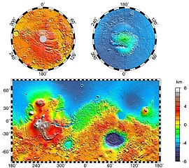
English: Maps of Mars' global topography. The projections are Mercator to 70° latitude and stereographic at the poles with the south pole at left and north pole at right. Note the elevation difference between the northern and southern hemispheres. The Tharsis volcano-tectonic province is centered near the equator in the longitude range 220° E to 300° E and contains the vast east-west trending Valles Marineris canyon system and several major volcanic shields including Olympus Mons (18° N, 225° E), Alba Patera (42° N, 252° E), Ascraeus Mons (12° N, 248° E), Pavonis Mons (0°, 247° E), and Arsia Mons (9° S, 239° E). Regions and structures discussed in the text include Solis Planum (25° S, 270° E), Lunae Planum (10° N, 290° E), and Claritas Fossae (30° S, 255° E). Major impact basins include Hellas (45° S, 70° E), Argyre (50° S, 320° E), Isidis (12° N, 88° E), and Utopia (45° N, 110° E). This analysis uses an areocentric coordinate convention with east longitude positive.
Русский: Топографическая карта Марса. |
| 日期 | |
| 来源 |
http://photojournal.jpl.nasa.gov/jpeg/PIA02031.jpg
|
| 作者 | NASA/JPL-Caltech/GSFC |
| 授权 (二次使用本文件) |
PD-USGOV-NASA |
| 此标签不表示文件的著作权状态。任何文件在附有此标签的同時还需要一个有效的著作权标签。请参阅许可协议说明页面以了解更多信息。 其他语言:
|
许可协议
| 本文件完全由NASA创作,在美国属于公有领域。根据NASA的版权方针,NASA的材料除非另有声明否则不受版权保护。(参见Template:PD-USGov/zh、NASA版权方针页面或JPL图片使用方针。) | ||
 |
警告:
|
原始上传日志
原始描述頁面位於這裡。下列使用者名稱均來自en.wikipedia。
- 2004-05-06 16:52 Wwoods 612×545×8 (88223 bytes) Topographic Map of Mars; http://photojournal.jpl.nasa.gov/catalog/PIA02031 ; {{msg:PD}}
| 註解 | 該圖片含有註解:在維基媒體共享資源上查看註解 |


文件历史
点击某个日期/时间查看对应时刻的文件。
| 日期/时间 | 缩略图 | 大小 | 用户 | 备注 | |
|---|---|---|---|---|---|
| 当前 | 2005年3月22日 (二) 00:43 | | 2,497 × 2,221(1.09 MB) | Wikibob~commonswiki | high res jpg from http://photojournal.jpl.nasa.gov/jpeg/PIA02031.jpg PD |
| 2004年12月30日 (四) 16:40 |  | 612 × 545(86 KB) | Kristaga | NASA-photo, all NASA images are free to use. |
文件用途
全域文件用途
以下其他wiki使用此文件:
- als.wikipedia.org上的用途
- ar.wikipedia.org上的用途
- be.wikipedia.org上的用途
- bg.wikipedia.org上的用途
- bo.wikipedia.org上的用途
- ca.wikipedia.org上的用途
- ca.wikibooks.org上的用途
- cv.wikipedia.org上的用途
- de.wikipedia.org上的用途
- el.wikipedia.org上的用途
- en.wikipedia.org上的用途
- User:Mcdavis941/mars
- Wikipedia:Reference desk/Science/Archive
- User:Scholar743/subpage3
- Mars ocean theory
- Phaethontis quadrangle
- Water on Mars
- Ptolemaeus (Martian crater)
- Tader Valles
- Gorgonum Chaos
- Wikipedia:Reference desk/Archives/Science/2010 September 26
- User talk:Wikileadspresident
- List of largest craters in the Solar System
- User:Jimmarsmars/sandbox
- Lakes on Mars
- en.wikiversity.org上的用途
- es.wikipedia.org上的用途
- eu.wikipedia.org上的用途
- fa.wikipedia.org上的用途
- fi.wikipedia.org上的用途
- fr.wikipedia.org上的用途
- gl.wikipedia.org上的用途
- he.wikipedia.org上的用途
- hi.wikipedia.org上的用途
- hr.wikipedia.org上的用途
- hu.wikipedia.org上的用途
查看本文件的更多全域用途。