File:Maskat & Oman map.png

本预览的尺寸:567 × 599像素。 其他分辨率:227 × 240像素 | 454 × 480像素 | 763 × 806像素。
原始文件 (763 × 806像素,文件大小:21 KB,MIME类型:image/png)

|
此map图片可使用矢量图形重新创建为SVG文件。这具有很多好处;更多信息请参见共享资源:待清理媒体。如果存在此图片的SVG格式,请将其上传,然后将此模板替换为
{{vector version available|新图片名称}}。
建议您将SVG命名为“Maskat & Oman map.svg”,这样在使用Vector version available(或Vva)模板时就不需要填写新图片名称参数。 |
| 描述 |
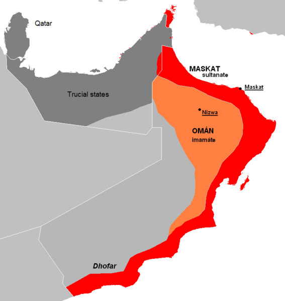
English: The approximate map of historic state of Mascat and Oman.
Čeština: Přibližná mapa historického státu Maskat a Omán |
| 日期 | (UTC) |
| 来源 | |
| 作者 |
|
| 其他版本 | العربيَّة |
| 这是一张修改过的图片,这意味着它已在原版本的基础上通过软件进行了编辑,改动内容:de facto new map, viz. description。其原始版本为:Al Hajar mountain woodlands map.png。修改者: Kolomaznik。
|
| 我,本作品著作权人,释出本作品至公有领域。这适用于全世界。 在一些国家这可能不合法;如果是这样的话,那么: 我无条件地授予任何人以任何目的使用本作品的权利,除非这些条件是法律规定所必需的。 |
原始上传日志
This image is a derivative work of the following images:
- File:AT1306_map.png licensed with PD-self
- 2008-02-27T09:16:44Z Doreano 763x806 (23794 Bytes) {{Information |Description=Gulf of Oman desert and semi-desert ecoregion map |Source=self-made |Date=2008/2/27 |Author= [[User:Altatoron|Altatoron]] |Permission= |other_versions= }} [[Category:Biomes]] [[Category:Biogeography
- File:AT0801_map.png licensed with PD-self
- 2008-02-27T09:10:47Z Doreano 676x806 (18852 Bytes) {{Information |Description=Al Hajar montane woodlands ecoregion map |Source=self-made |Date=2008/2/27 |Author= [[User:Altatoron|Altatoron]] |Permission= |other_versions= }} [[Category:Biomes]] [[Category:Biogeography]] [[Cate
Uploaded with derivativeFX
文件历史
点击某个日期/时间查看对应时刻的文件。
| 日期/时间 | 缩略图 | 大小 | 用户 | 备注 | |
|---|---|---|---|---|---|
| 当前 | 2015年7月7日 (二) 22:36 | | 763 × 806(21 KB) | History of Persia | Made it easier to understand. |
| 2010年5月28日 (五) 19:06 |  | 763 × 806(27 KB) | Kolomaznik | {{Information |Description={{en}}The approximate map of historic state of Mascat and Oman. {{cs}}Přibližná mapa historického státu Maskat a Omán |Source=*File:AT1306_map.png *File:AT0801_map.png |Date=2010-05-28 19:02 (UTC) |Author=*[[:F |
文件用途
全域文件用途
以下其他wiki使用此文件:
- ar.wikipedia.org上的用途
- az.wikipedia.org上的用途
- cs.wikipedia.org上的用途
- de.wikipedia.org上的用途
- el.wikipedia.org上的用途
- en.wikipedia.org上的用途
- es.wikipedia.org上的用途
- eu.wikipedia.org上的用途
- fa.wikipedia.org上的用途
- fi.wikipedia.org上的用途
- fr.wikipedia.org上的用途
- he.wikipedia.org上的用途
- id.wikipedia.org上的用途
- it.wikipedia.org上的用途
- ko.wikipedia.org上的用途
- mn.wikipedia.org上的用途
- ms.wikipedia.org上的用途
- nl.wikipedia.org上的用途
- pl.wikipedia.org上的用途
- pt.wikipedia.org上的用途
- ru.wikipedia.org上的用途
- sl.wikipedia.org上的用途
- th.wikipedia.org上的用途
- tr.wikipedia.org上的用途
- uk.wikipedia.org上的用途
- vi.wikipedia.org上的用途
- www.wikidata.org上的用途