File:Mercator north pole 1595.jpg
本预览的尺寸:635 × 600像素。 其他分辨率:254 × 240像素 | 508 × 480像素 | 813 × 768像素 | 1,084 × 1,024像素 | 1,700 × 1,606像素。
原始文件 (1,700 × 1,606像素,文件大小:1.13 MB,MIME类型:image/jpeg)
摘要
| 描述 |
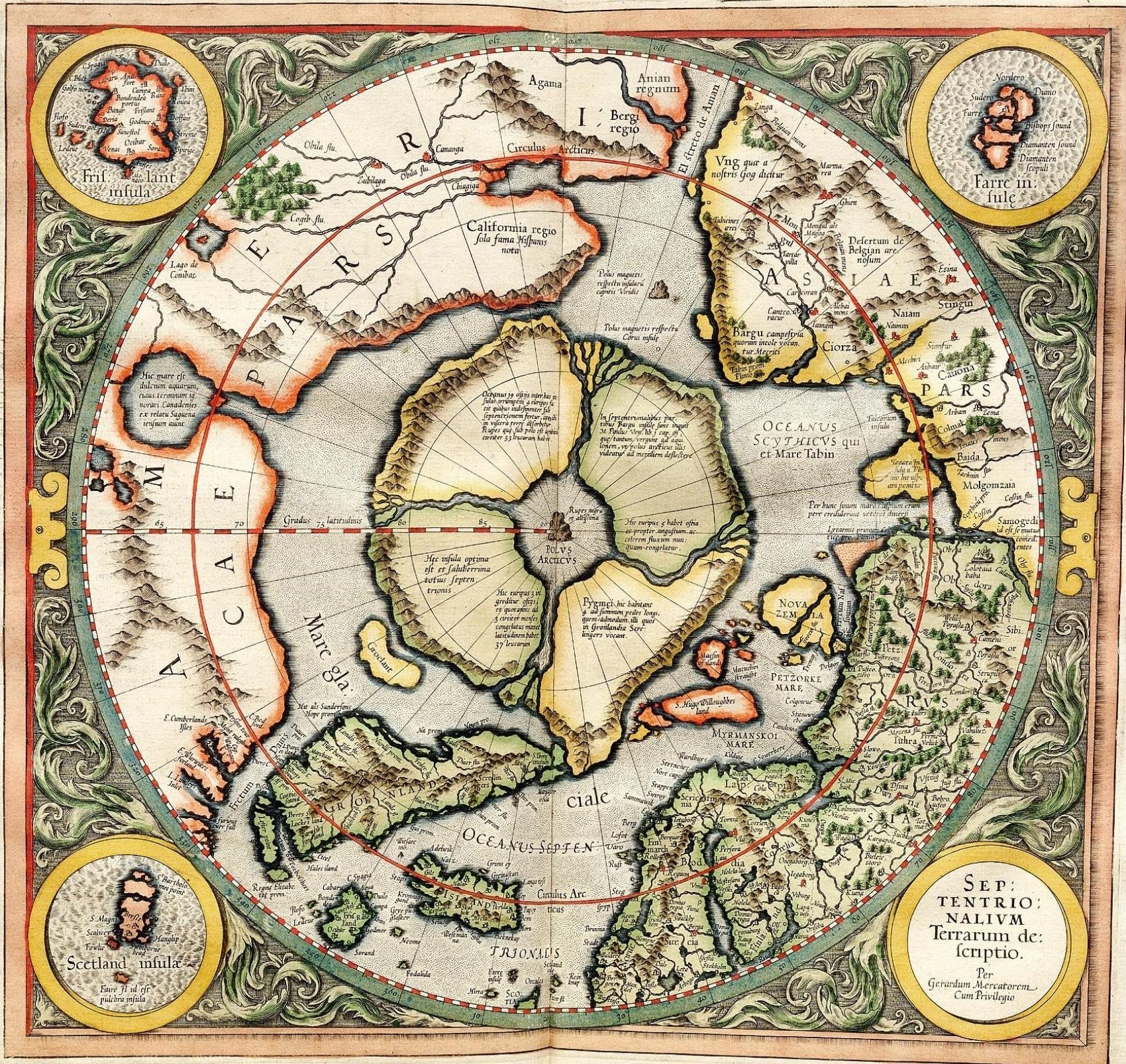
Mercator's 1595 map of the Arctic. Mercator, Gerhard, 1512-1594. "Septentrionalium Terrarum descriptio" [1595]. First state, from his posthumously published atlas, Atlantis pars altera. |
||||||||||||||||||||||||||
| 日期 | |||||||||||||||||||||||||||
| 来源 | http://libweb5.princeton.edu/visual_materials/maps/websites/northwest-passage/mercator.htm | ||||||||||||||||||||||||||
| 作者 |
|
||||||||||||||||||||||||||
| 授权 (二次使用本文件) |
|
||||||||||||||||||||||||||

许可协议
|
本作品在其来源国以及其他著作权期限是作者逝世后100年或以下的国家和地区属于公有领域。 | |
| 本文件已被确认为免除已知的著作权法限制(包括所有相关权利)。 | |
_-_Geographicus_-_NorthPole-mercator-1606.jpg)
]
文件历史
点击某个日期/时间查看对应时刻的文件。
| 日期/时间 | 缩略图 | 大小 | 用户 | 备注 | |
|---|---|---|---|---|---|
| 当前 | 2008年3月14日 (五) 11:32 | | 1,700 × 1,606(1.13 MB) | Pallidio~commonswiki | {{Information |Description= |Source= |Date= |Author= |Permission= |other_versions= }} Maps made in the 16th century | Gerardus Mercator | Maps by Gerardus Mercator | 1595 | Old maps of the world | |
文件用途
以下页面使用本文件:
全域文件用途
以下其他wiki使用此文件:
- ba.wikipedia.org上的用途
- be-tarask.wikipedia.org上的用途
- be.wikipedia.org上的用途
- de.wikipedia.org上的用途
- en.wikipedia.org上的用途
- eo.wikipedia.org上的用途
- es.wikipedia.org上的用途
- fr.wikipedia.org上的用途
- hy.wikipedia.org上的用途
- it.wikipedia.org上的用途
- ja.wikipedia.org上的用途
- ka.wikipedia.org上的用途
- la.wikipedia.org上的用途
- nl.wikipedia.org上的用途
- pa.wikipedia.org上的用途
- pl.wikipedia.org上的用途
- ru.wikipedia.org上的用途
- sv.wikipedia.org上的用途
- te.wikipedia.org上的用途
- te.wiktionary.org上的用途
- tt.wikipedia.org上的用途