File:Mississippi-Coast-towns-NOAA.jpg
此为最大尺寸。
Mississippi-Coast-towns-NOAA.jpg (750 × 382像素,文件大小:57 KB,MIME类型:image/jpeg)

|
此map图片可使用矢量图形重新创建为SVG文件。这具有很多好处;更多信息请参见共享资源:待清理媒体。如果存在此图片的SVG格式,请将其上传,然后将此模板替换为
{{vector version available|新图片名称}}。
建议您将SVG命名为“Mississippi-Coast-towns-NOAA.svg”,这样在使用Vector version available(或Vva)模板时就不需要填写新图片名称参数。 |


摘要
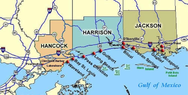
| 描述 | Coastal map of the U.S. state of Mississippi, showing major towns and cities in the three coastal counties: Hancock, Harrison, and Jackson County. Also shown are Cat Island, West Ship Island, East Ship Island, Horn Island and Petit Bois Island.The locations of towns, roads and offshore islands are based on NOAA and NASA maps. |
| 日期 | |
| 来源 |
自己的作品; self-made (hand-edited with MS-Paint)
Pure stupidity: The map is in quick JPEG format, for large display as highly readable, in about 20 articles that display the map. JPEG clarity is enhanced by painted areas behind many labels, causing the wording to be clearer than even a massive SVG or PNG-format file could provide, due to the sharp display contrast of JPEG files. JPEG Clarity: Even though JPEG images have artifacts, they can display clearer wording in small maps due to auto-contrast enhancement. The same painted/shaded areas, that illuminate wording, would make the map excessively gargantuan in slow cumbersome PNG or SVG format, as is the case with terrain maps, which also should NEVER be converted to massive PNG format. |
| 作者 | Wikid77 |
许可协议
| 本作品已被作者I, Wikid77释出到公有领域。这适用于全世界。 在一些国家这可能不合法;如果是这样的话,那么: I, Wikid77无条件地授予任何人以任何目的使用本作品的权利,除非这些条件是法律规定所必需的。 |
文件历史
点击某个日期/时间查看对应时刻的文件。
| 日期/时间 | 缩略图 | 大小 | 用户 | 备注 | |
|---|---|---|---|---|---|
| 当前 | 2007年6月26日 (二) 02:54 | | 750 × 382(57 KB) | Wikid77 | Brown-toned map: Hancock County as tan (was green); put "Gulf of Mexico" Antigua font; shift labels on islands |
| 2007年6月26日 (二) 00:17 |  | 750 × 382(56 KB) | Wikid77 | Mississippi coastal map, with "Horn Island" relabeled, clarified Hwy "90" and "63" icons. | |
| 2007年6月21日 (四) 18:56 |  | 750 × 382(56 KB) | Wikid77 | re-load of image file, in case internal data was garbled | |
| 2007年6月21日 (四) 18:11 |  | 750 × 382(56 KB) | Wikid77 | {{Information |Description=Coastal map of the U.S. state of en:Mississippi, showing major towns and cities in the 3 coastal counties: Hancock, Harrison, a |
文件用途
以下页面使用本文件:
全域文件用途
以下其他wiki使用此文件:
- ca.wikipedia.org上的用途
- de.wikipedia.org上的用途
- en.wikipedia.org上的用途
- Hancock County, Mississippi
- Pearlington, Mississippi
- Waveland, Mississippi
- Biloxi, Mississippi
- Gulfport, Mississippi
- Long Beach, Mississippi
- Gautier, Mississippi
- Ocean Springs, Mississippi
- Pascagoula Abduction
- Effects of Hurricane Katrina in Mississippi
- Ship Island
- Horn Island Chemical Warfare Service Quarantine Station
- fr.wikipedia.org上的用途
- fy.wikipedia.org上的用途
- he.wikipedia.org上的用途
- hu.wikipedia.org上的用途
- it.wikipedia.org上的用途
- ja.wikipedia.org上的用途
- pt.wikipedia.org上的用途
- tr.wikipedia.org上的用途
- vi.wikipedia.org上的用途