File:NUTS 3 regions of North East England map.svg

此SVG文件的PNG预览的大小:482 × 599像素。 其他分辨率:193 × 240像素 | 386 × 480像素 | 618 × 768像素 | 824 × 1,024像素 | 1,647 × 2,048像素 | 1,082 × 1,345像素。
原始文件 (SVG文件,尺寸为1,082 × 1,345像素,文件大小:714 KB)
摘要
| 描述 |
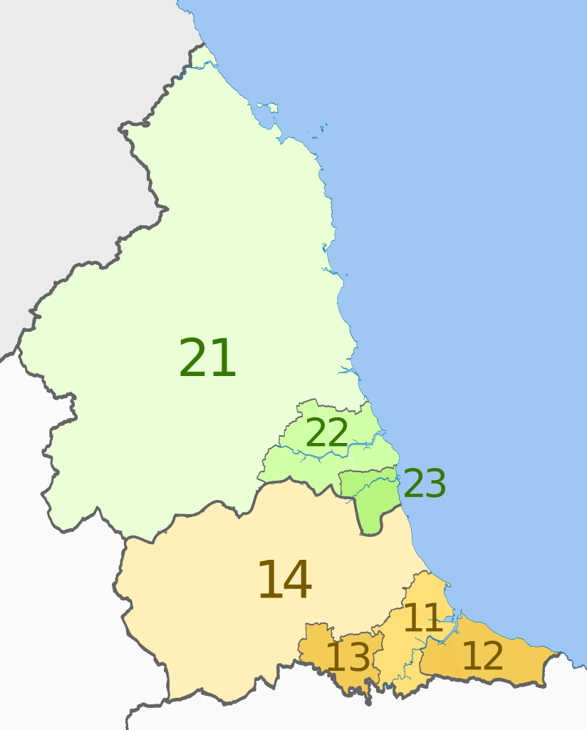
English: Map of the NUTS 3 regions of North East England.
Equirectangular map projection on WGS 84 datum, with N/S stretched 170% Geographic limits:
|
| 日期 | (UTC) |
| 来源 |
本檔案衍生自: |
| 作者 |
|


| NUTS 1 | Code | NUTS 2 | Code | NUTS 3 | Code |
|---|---|---|---|---|---|
| North East, England | UKC | Tees Valley and Durham | UKC1 | Hartlepool and Stockton-on-Tees | UKC11 |
| South Teesside (Middlesbrough and Redcar and Cleveland) | UKC12 | ||||
| Darlington | UKC13 | ||||
| Durham | UKC14 | ||||
| Northumberland and Tyne and Wear | UKC2 | ||||
| Northumberland | UKC21 | ||||
| Tyneside (Newcastle upon Tyne, Gateshead, South Tyneside, North Tyneside) | UKC22 | ||||
| Sunderland | UKC23 |
许可协议
本文件采用知识共享署名-相同方式共享 3.0 未本地化版本许可协议授权。
署名: Dr Greg and Nilfanion. Contains Ordnance Survey data © Crown copyright and database right 2011
- 您可以自由地:
- 共享 – 复制、发行并传播本作品
- 修改 – 改编作品
- 惟须遵守下列条件:
- 署名 – 您必须对作品进行署名,提供授权条款的链接,并说明是否对原始内容进行了更改。您可以用任何合理的方式来署名,但不得以任何方式表明许可人认可您或您的使用。
- 相同方式共享 – 如果您再混合、转换或者基于本作品进行创作,您必须以与原先许可协议相同或相兼容的许可协议分发您贡献的作品。
原始上传日志
This image is a derivative work of the following images:
- File:North_East_England__districts_2011_map.svg licensed with Cc-by-sa-3.0, GFDL
- 2011-05-01T18:56:43Z Nilfanion 1082x1345 (714062 Bytes) == Summary == {{Information |Description=Map of the [[w:North East England|North East England]] region showing the administrative districts. Equirectangular map projection on WGS 84 datum, with N/S stretched 170% Geographic
- File:English_ceremonial_counties_2010.svg licensed with Cc-by-sa-3.0, GFDL
- 2010-11-23T16:39:55Z Nilfanion 1108x1345 (308868 Bytes) thicker lines
- 2010-11-23T16:20:19Z Nilfanion 1108x1345 (301520 Bytes) tweaks
- 2010-10-26T20:34:20Z Nilfanion 817x990 (1391832 Bytes) {{Information |Description=Map showing the [[w:ceremonial counties of England]] including the City of London, in 2010. Equirectangular map projection on WGS 84 datum, with N/S stretched 170% Geographic limits: *West: 6.75W
Uploaded with derivativeFX
文件历史
点击某个日期/时间查看对应时刻的文件。
| 日期/时间 | 缩略图 | 大小 | 用户 | 备注 | |
|---|---|---|---|---|---|
| 当前 | 2012年6月4日 (一) 21:27 | | 1,082 × 1,345(714 KB) | Dr Greg | == {{int:filedesc}} == {{Information |Description=Map of the NUTS 3 regions of North East England. Equirectangular map projection on WGS 84 datum, with N/S stretched 170... |
文件用途
以下页面使用本文件:
全域文件用途
以下其他wiki使用此文件:
- bn.wikipedia.org上的用途
- de.wikipedia.org上的用途
- en.wikipedia.org上的用途
- fi.wikipedia.org上的用途
- it.wikipedia.org上的用途
- lt.wikipedia.org上的用途
- ru.wikipedia.org上的用途