File:Noord-Brabant position.svg

此SVG文件的PNG预览的大小:200 × 236像素。 其他分辨率:203 × 240像素 | 407 × 480像素 | 651 × 768像素 | 868 × 1,024像素 | 1,736 × 2,048像素。
原始文件 (SVG文件,尺寸为200 × 236像素,文件大小:158 KB)
摘要
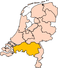
| 描述 | Location of the province of Noord-Brabant (North Brabant) in the Netherlands. |
| 日期 | |
| 来源 | Own work, based on freely available GIS data |
| 作者 | User:Mtcv |
| 授权 (二次使用本文件) |
Data: attribution required; my work: PD |
| 其他版本 | I attempted to make an svg version of Image:Noord Brabant-Position.png (with less simplified boundaries) |
Clickable version

许可协议

|
本文件的著作权人,Centraal Bureau voor de Statistiek,允许任何人在适当地表明著作权人的姓名的前提下,以任何目的使用本文件。传播,演绎作品,商业用途及所有其他用途被允许。 |
|
|
| 註解 | 該圖片含有註解:在維基媒體共享資源上查看註解 |


文件历史
点击某个日期/时间查看对应时刻的文件。
| 日期/时间 | 缩略图 | 大小 | 用户 | 备注 | |
|---|---|---|---|---|---|
| 当前 | 2019年3月2日 (六) 17:20 | | 200 × 236(158 KB) | Thayts | update |
| 2006年10月3日 (二) 00:49 |  | 200 × 236(158 KB) | Mtcv | {{Information| |Description=Location of the province of Noord-Holland (North Holland) in the Netherlands. |Source=Own work, based on freely available GIS data |Date=2006-10-03 |Author=User:Mtcv |Permission=Data: attribution required; my work: PD |othe |
文件用途
以下65个页面使用本文件:
- 于登
- 克伊克
- 克拉嫩东克
- 兰德尔德
- 勒瑟尔-德米尔登
- 北布拉班特省
- 博克斯梅尔
- 博克斯特爾
- 呂克芬
- 哈倫 (北布拉班特省)
- 哈尔德贝赫
- 圣米希尔斯海斯特尔
- 埃因霍温
- 埃滕-勒爾
- 埃爾瑟爾
- 奥尔斯霍特
- 奥斯
- 奧斯特豪特
- 奧斯特韋克
- 尼嫩、海尔文和下韦滕
- 巴勒拿骚
- 市镇 (荷兰)
- 布克爾
- 布拉德爾
- 布雷达
- 希尔法伦贝克
- 希尔泽和赖恩
- 德尔讷
- 德里默倫
- 拉尔贝克
- 斯海尔托亨博斯
- 斯滕贝亨
- 栋恩
- 法尔肯斯瓦德
- 洛恩奥普赞德
- 津德尔特
- 海尔德罗普-米尔洛
- 海澤-倫德
- 海爾蒙德
- 海特勒伊登貝赫
- 海默特-巴克爾
- 瓦尔勒
- 瓦尔韦克
- 穆尔代克
- 米尔和圣许贝特
- 索恩和布勒赫尔
- 索默倫
- 罗森达尔
- 翁斯德雷赫特
- 聖安東尼斯
- 菲赫特
- 蒂尔堡
- 貝亨奧普佐姆
- 貝斯特 (荷蘭)
- 贝伦海泽
- 贝赫艾克
- 费尔德霍芬
- 赫拉弗
- 赫斯登
- 迈厄赖斯塔德
- 阿尔特纳 (北布拉班特省)
- 阿斯滕
- 阿爾芬-哈姆
- 霍尔勒
- Template:North Brabant Province
全域文件用途
以下其他wiki使用此文件:
- ar.wikipedia.org上的用途
- شمال بربنت
- آيندهوفن
- بريدا
- بارله ناساو
- تيلبورخ
- سيرتوخيمبوس
- قالب:بلديات شمال برابنت
- آلبورخ
- ألفن- كام
- أستن
- بيرخ آيك
- فيلدهوفن
- بيرخن أوب زووم
- بيرنهيزه
- بيست (هولندا)
- بلادل
- بوكل
- بوكسمير
- بوكستل
- كرانندونك
- كاوك
- دورنه
- دونجن
- دريميلين
- إيرسل
- إيتن- لور
- خيرتراودنبيرخ
- خيلدروب- ميرلو
- خيميرت- باكل
- خيلزه آن راين
- خورلا
- خرافه (هولندا)
- هارن (شمال برابنت)
- هالدربيرخه
- هيزه- لينده
- هيلموند
- هوسدن
- هيلفارينبيك
- لاربيك
- لانديرد
- لوب أوب زند
- مل آن سينت هوبرت
- موردايك
- نونن (خيرفن آن نيدرفيتن)
- أويرشخوت
- أويسترفايك
- أوسترهاوت
- أوس (هولندا)
- روسل- دي ميردن
- روسيندال
查看本文件的更多全域用途。