File:Paraná River Floodplain.jpg
此为最大尺寸。
Paraná_River_Floodplain.jpg (720 × 480像素,文件大小:179 KB,MIME类型:image/jpeg)
| 描述 |
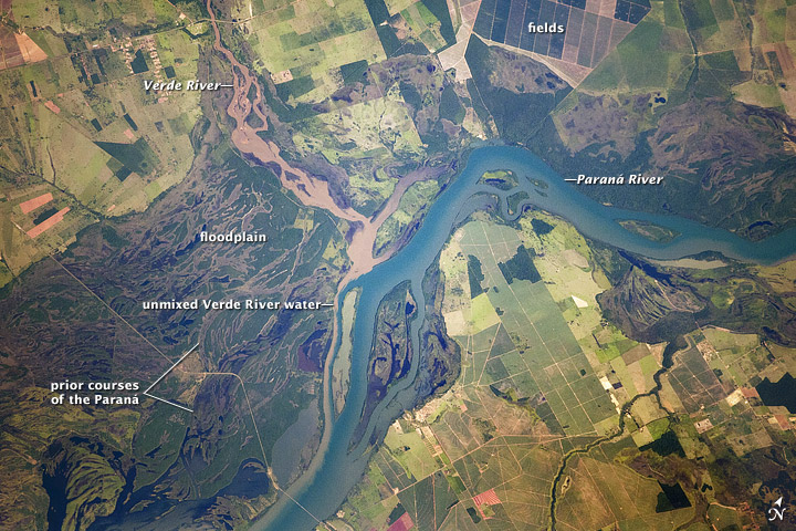
English: Paraná River Floodplain, Brazil
The Paraná River appears as a wide, blue strip with the muddy brown water of the smaller Verde River entering from the northwest (top left). An extensive wetland (dark green) occupies most of the left half of this astronaut photograph, and the floodplain reaches a width of 11 kilometers (about 7 miles). The thin line of a road crossing the floodplain also gives a sense of scale. Above the Paraná-Verde confluence (image center), the floodplain is much narrower. |
|||||
| 日期 | acquired on February 5, 2012 | |||||
| 来源 | http://earthobservatory.nasa.gov/IOTD/view.php?id=77444&src=eoa-iotd | |||||
| 作者 | NASA Astronaut photograph ISS030-E-90012 | |||||
| 授权 (二次使用本文件) |
|
|||||
| 其他版本 | See [4] for a larger version |

![[4]](http://eoimages.gsfc.nasa.gov/images/imagerecords/77000/77444/ISS030-E-090012_lrg.jpg)
文件历史
点击某个日期/时间查看对应时刻的文件。
| 日期/时间 | 缩略图 | 大小 | 用户 | 备注 | |
|---|---|---|---|---|---|
| 当前 | 2012年3月22日 (四) 18:28 | | 720 × 480(179 KB) | Tillman | {{Information |Description ={{en|1=Paraná River Floodplain, Brazil The Paraná River appears as a wide, blue strip with the muddy brown water of the smaller Verde River entering from the northwest (top left). An extensive wetland (dark green) occu... |
文件用途
以下页面使用本文件:
全域文件用途
以下其他wiki使用此文件:
- ba.wikipedia.org上的用途
- bh.wikipedia.org上的用途
- bn.wikipedia.org上的用途
- ca.wikipedia.org上的用途
- din.wikipedia.org上的用途
- en.wikipedia.org上的用途
- eo.wikipedia.org上的用途
- fi.wikipedia.org上的用途
- ja.wikipedia.org上的用途
- sl.wikipedia.org上的用途
- sr.wikipedia.org上的用途
- uk.wikipedia.org上的用途
- vi.wikipedia.org上的用途
- war.wikipedia.org上的用途
- www.wikidata.org上的用途