File:Persia 600ad.jpg
原始文件 (1,098 × 623像素,文件大小:644 KB,MIME类型:image/jpeg)
Rest

|
此historical map图片可使用矢量图形重新创建为SVG文件。这具有很多好处;更多信息请参见共享资源:待清理媒体。如果存在此图片的SVG格式,请将其上传,然后将此模板替换为
{{vector version available|新图片名称}}。
建议您将SVG命名为“Persia 600ad.svg”,这样在使用Vector version available(或Vva)模板时就不需要填写新图片名称参数。 |


摘要
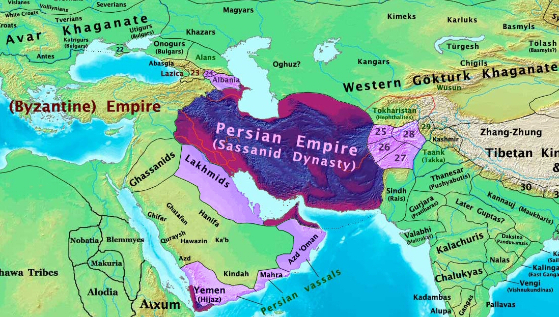
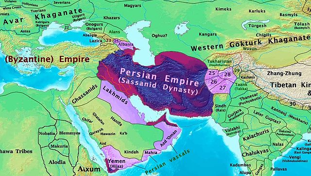
| 描述 | The Persian Sassanid Empire in 600 AD. |
| 日期 | |
| 来源 | 自己的作品 |
| 作者 | Thomas Lessman (Contact!) |
| 授权 (二次使用本文件) |
我,本作品著作权人,特此采用以下许可协议发表本作品: 本文件采用知识共享署名-相同方式共享 3.0 未本地化版本许可协议授权。
|
| 其他版本 | see below |
Map Summary

Original Source URL: http://www.thomaslessman.com/History/images/East-Hem_600ad.jpg
This map is a zoomed-in version of Thomas Lessman's map of the
East-Hem_600ad.jpg (also available at www.WorldHistoryMaps.info).
The highlighted areas represent the Persian Sassanid Empire and its territories in the year 600 AD (before the Great Romano-Persian war).
Map Source References
Remember, sources often conflict with each other. This map is only as accurate as the information that is available to me. To report any errors or to help further this work, please click here, or email Thomas Lessman at talessman@yis.us
References for information contained in this map:
Other Maps by Thomas Lessman
| Maps of the eastern hemisphere showing history
Bold dates are available on Wikimedia or Wikipedia. | ||
| Primeval | ||
| Ancient
|
·| 600 BC | 550 BC | 527 BC | 500 BC |
400 BC | ·| 1 AD | 50 AD | 100 AD | 200 AD | 300 AD | | |
| Medieval |
·| 500 AD | 565 AD | 600 AD | 700 AD | | |
| Modern |
·| 1500 AD | · * For historical maps of the whole world, | |
Other Info
原始上传日志
- 2008-01-30 00:27 Talessman 1724×814×8 (267093 bytes) This image is a zoomed-in version of [http://en.wikipedia.org/wiki/Image:East-Hem_600ad.jpg Eastern Hemisphere in 600 AD]. The highlighted area is the Persian Sassanid Empire. [[Image:East-Hem_600ad.jpg|thumb|300px|left|Eastern Hemisphere in 600 AD.]] Author: T
文件历史
点击某个日期/时间查看对应时刻的文件。
| 日期/时间 | 缩略图 | 大小 | 用户 | 备注 | |
|---|---|---|---|---|---|
| 当前 | 2015年12月7日 (一) 19:44 | | 1,098 × 623(644 KB) | B | Removed obnoxious label |
| 2008年8月21日 (四) 21:00 |  | 1,098 × 623(813 KB) | Talessman | Updated version of the parent map. This new version features colored areas to highlight the Persian Empire and its vassal states. | |
| 2008年4月28日 (一) 17:25 |  | 1,724 × 814(261 KB) | Producer | {{Information |Description={{en|This image is a zoomed-in version of [http://en.wikipedia.org/wiki/Image:East-Hem_600ad.jpg Eastern Hemisphere in 600 AD]. The highlighted area is the Sassanid Persian Empire. [[:en:Image:East-Hem_600ad.jpg|thumb|300px|lef |
文件用途
以下4个页面使用本文件:
全域文件用途
以下其他wiki使用此文件:
- ar.wikipedia.org上的用途
- as.wikipedia.org上的用途
- azb.wikipedia.org上的用途
- bn.wikipedia.org上的用途
- ca.wikipedia.org上的用途
- cs.wikipedia.org上的用途
- de.wikipedia.org上的用途
- el.wikipedia.org上的用途
- en.wikipedia.org上的用途
- es.wikipedia.org上的用途
- fa.wikipedia.org上的用途
- fr.wikipedia.org上的用途
- hi.wikipedia.org上的用途
- hy.wikipedia.org上的用途
- hyw.wikipedia.org上的用途
- id.wikipedia.org上的用途
- incubator.wikimedia.org上的用途
- is.wikipedia.org上的用途
- it.wikipedia.org上的用途
- ja.wikipedia.org上的用途
- ka.wikipedia.org上的用途
查看本文件的更多全域用途。