File:Port Phillip 10,000.PNG
此为最大尺寸。
Port_Phillip_10,000.PNG (514 × 523像素,文件大小:20 KB,MIME类型:image/png)

|
此文件是通过机器人脚本从en.wikipedia移动到维基共享资源的。来源中的所有信息均已保留,但仍需要人工的审阅。部分或所有的信息可能会出现在错误的区域;只有在经过审阅并修正需改正的错误后,此文件的相关信息才能视为可使用。当审阅结束后,请移除本模板,更详细的信息参见下方。 现在就开始检查! |
摘要
| 描述 |
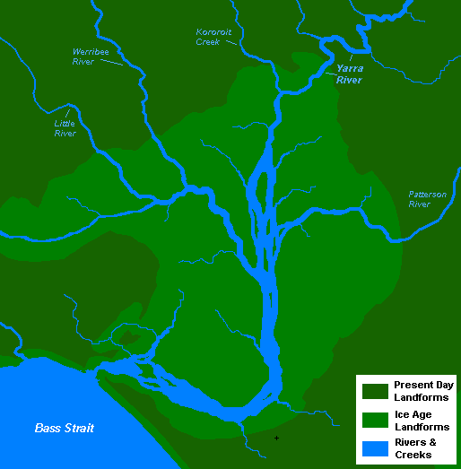
English: A very basic map of the port phillip plains approximately 10-12 thousand years ago, prior to sea level rise that filled the area of land now known as Port Phillip, and the course of the Yarra River as it emptied into Bass Strait. More exact details regarding the course of the Yarra River in the port phillip plains are needed. |
| 日期 | 2008年11月13日 (原始上传日期) |
| 来源 | 自己的作品 |
| 作者 | 英语维基百科的Nick carson |
许可协议
| 本作品已被作者英语维基百科的Nick carson释出到公有领域。这适用于全世界。 在一些国家这可能不合法;如果是这样的话,那么: Nick carson无条件地授予任何人以任何目的使用本作品的权利,除非这些条件是法律规定所必需的。 |
原始上传日志
原始描述頁面位於這裡。下列使用者名稱均來自en.wikipedia。
- 2008-11-13 14:20 Nick carson 514×523 (20321 bytes) A very basic map of the port phillip plains approximately 10-12 thousand years ago, prior to sea level rise that filled the area of land now known as Port Phillip, and the course of the Yarra River as it emptied into Bass Strait. More exact details regard
文件历史
点击某个日期/时间查看对应时刻的文件。
| 日期/时间 | 缩略图 | 大小 | 用户 | 备注 | |
|---|---|---|---|---|---|
| 当前 | 2012年1月7日 (六) 19:12 | | 514 × 523(20 KB) | BotMultichillT | {{BotMoveToCommons|en.wikipedia|year={{subst:CURRENTYEAR}}|month={{subst:CURRENTMONTHNAME}}|day={{subst:CURRENTDAY}}}} == {{int:filedesc}} == {{Information |description={{en|1=A very basic map of the port phillip plains approximately 10-12 thousand years |
文件用途
全域文件用途
以下其他wiki使用此文件:
- af.wikipedia.org上的用途
- en.wikipedia.org上的用途
- sr.wikipedia.org上的用途