File:Portuguese colonial war map1.PNG
此为最大尺寸。
Portuguese_colonial_war_map1.PNG (360 × 392像素,文件大小:12 KB,MIME类型:image/png)

|
File:Portuguese colonial war blank map.svg是此文件的矢量版本。 如果此文件质量不低于原点阵图,就应该将这个PNG格式文件替换为此文件。
File:Portuguese colonial war map1.PNG → File:Portuguese colonial war blank map.svg
更多信息请参阅Help:SVG/zh。 |
 |
摘要
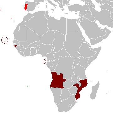
Map of the Portuguese colonies in Africa by the time of the Portuguese Colonial War (1961-1974).
Source
- English Wikipedia, uploaded by User:Mário
Revision history
12:19, 8 April 2006 . . Mário (Talk | contribs) . . 360×392 (12,409 bytes) (Map of the Portuguese colonies in Africa by the time of the Portuguese Colonial War (1961-1974).)
许可协议
| 我,本作品著作权人,释出本作品至公有领域。这适用于全世界。 在一些国家这可能不合法;如果是这样的话,那么: 我无条件地授予任何人以任何目的使用本作品的权利,除非这些条件是法律规定所必需的。 |
文件历史
点击某个日期/时间查看对应时刻的文件。
| 日期/时间 | 缩略图 | 大小 | 用户 | 备注 | |
|---|---|---|---|---|---|
| 当前 | 2008年3月5日 (三) 10:17 | | 360 × 392(12 KB) | The Ogre | Enhanced visualization |
| 2007年11月26日 (一) 19:51 |  | 360 × 392(12 KB) | Hoshie | added Cabinda, updated base map | |
| 2006年8月12日 (六) 14:46 |  | 360 × 392(12 KB) | Nuno Tavares | == Summary == Map of the Portuguese colonies in Africa by the time of the Portuguese Colonial War (1961-1974). ==Source== <pre> 12:19, 8 April 2006 . . Mário (Talk | contribs) . . 360×392 (12,409 bytes) (Map of the Portuguese colonies i |
文件用途
没有页面链接到本图像。
全域文件用途
以下其他wiki使用此文件:
- de.wikipedia.org上的用途
- en.wikipedia.org上的用途
- fr.wikipedia.org上的用途
- ja.wikipedia.org上的用途