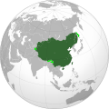
File:Qing dynasty in 1760.svg

此SVG文件的PNG预览的大小:600 × 600像素。 其他分辨率:240 × 240像素 | 480 × 480像素 | 768 × 768像素 | 1,024 × 1,024像素 | 2,048 × 2,048像素。
原始文件 (SVG文件,尺寸为600 × 600像素,文件大小:472 KB)
文件历史
点击某个日期/时间查看对应时刻的文件。
| 日期/时间 | 缩略图 | 大小 | 用户 | 备注 | |
|---|---|---|---|---|---|
| 当前 | 2023年9月24日 (日) 03:49 |  | 600 × 600(472 KB) | Cactus Ronin | Reverted to version as of 16:06, 28 September 2022 (UTC) |
| 2023年9月24日 (日) 03:15 |  | 600 × 600(475 KB) | Cactus Ronin | There is no ardchaeological nor documental evidence for Sakhalin being a Qing territory, except for "fur tributary" system. If being a "tributary" is enough to make one territory of another then we should attribute almost all of the world to British Empire, including Qing Dynasty, shall we? | |
| 2022年9月28日 (三) 16:06 |  | 600 × 600(472 KB) | Aldermanseven | changes based on File:China in 1820.svg | |
| 2022年9月27日 (二) 19:28 |  | 600 × 600(468 KB) | Aldermanseven | Uploaded own work with UploadWizard |
文件用途
超过100个页面使用本文件。 下面的列表只显示使用本文件的前100个页面。完整列表可用。
- User:A bomb150
- User:Adonai/userbox
- User:Alang7575
- User:Andrew1214/user
- User:Andykoo1990
- User:Benfeizhuzi
- User:Bensam
- User:Betoseha
- User:Blaster~zhwiki
- User:Bourquie
- User:Cabrera
- User:Ch.Andrew/info
- User:Chakhar
- User:Chenzhipeter
- User:Chenzhoubo
- User:CherishL
- User:Chu0106
- User:Dydso
- User:Eamb
- User:Etrade325
- User:Fzfasfafhrred
- User:Gauchisante
- User:Gzhao
- User:Hanslg
- User:Hkstudent
- User:Hugege
- User:Hyins
- User:Jack.H
- User:Jamblock
- User:Joamtcw
- User:Johnbobyray
- User:Justuschou
- User:Keasung
- User:Keithchui
- User:KevinAction
- User:Khris1112
- User:Kiaa
- User:Kohana
- User:Kwanchuntat
- User:Laichinwei
- User:Likemath
- User:Litianao
- User:MakChiYan
- User:Marco mmh
- User:Messyer
- User:Mohist2000
- User:Mwzzhang
- User:New c21112
- User:Ntdtv8964
- User:Penal
- User:Prinyau
- User:Qooleeman
- User:Quest for Truth
- User:Qumingcheng
- User:Red16
- User:River1 chow
- User:Robertyhn
- User:Sam1266
- User:Sarin~zhwiki
- User:Std310131
- User:Steelsnarl
- User:Szdp406
- User:Ternatcn
- User:Tonyshew
- User:Ueno7576
- User:Vermilionrock
- User:Victorcbornaparte
- User:Vivian schi
- User:Vphoenix
- User:Wahapure
- User:Weijiandao
- User:Wenlongtian
- User:Wtywty2006
- User:Wuyefeibao
- User:Xnj920327
- User:Yathimc
- User:Yeahsoo
- User:Yisiang
- User:YukiSakura
- User:冲之
- User:凱撒
- User:卫琉 马泰
- User:圍棋一級
- User:天临溟渊
- User:好名都不见了
- User:宵十一狼
- User:小鄧
- User:慕尼黑啤酒
- User:無日不鳴
- User:猩猩王
- User:立足东方
- User:筆俠
- User:聰
- User:藏狐
- User:虞海/2008至12年
- User:衖追命/巴別
- User:謙虔靜聽
- User talk:Joosungwoo
- User talk:Verachter
- User talk:泠泠
查看连接到这个文件的更多链接。
全域文件用途
以下其他wiki使用此文件:
- af.wikipedia.org上的用途
- alt.wikipedia.org上的用途
- ar.wikipedia.org上的用途
- bcl.wikipedia.org上的用途
- ca.wikipedia.org上的用途
- ce.wikipedia.org上的用途
- en.wikipedia.org上的用途
- es.wikipedia.org上的用途
- fa.wikipedia.org上的用途
- fr.wikipedia.org上的用途
- id.wikipedia.org上的用途
- ja.wikipedia.org上的用途
- ko.wikipedia.org上的用途
- lld.wikipedia.org上的用途
- mni.wikipedia.org上的用途
- mn.wikipedia.org上的用途
- ru.wikipedia.org上的用途
- simple.wikipedia.org上的用途
- sq.wikipedia.org上的用途
- th.wikipedia.org上的用途
- uk.wikipedia.org上的用途

