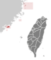
File:ROC Fuchien.png
ROC_Fuchien.png (362 × 425像素,文件大小:11 KB,MIME类型:image/png)
文件历史
点击某个日期/时间查看对应时刻的文件。
| 日期/时间 | 缩略图 | 大小 | 用户 | 备注 | |
|---|---|---|---|---|---|
| 当前 | 2019年9月26日 (四) 00:09 |  | 362 × 425(11 KB) | Geographyinitiative | The upload is an exact duplicate of an older version of File:ROC Fuchien.png. Restoring original. In the 2011 version, the subjectively drawn oceanic boundary for Lienchiang County (the Matsu Islands) doesn't reach around Dongyin Township- absurd. Also, the Dongding Island area is omitted in the 2011 map, equally absurd. Dongyin is too close to the edge in the 2011 map, whereas in the 2005 map you can see some of the areas north of Matsu- th... |
| 2011年6月4日 (六) 07:34 |  | 1,016 × 1,221(155 KB) | Energiya | 2010 ROC Administrative division reform | |
| 2005年5月16日 (一) 23:02 |  | 362 × 425(11 KB) | Ran |
文件用途
没有页面链接到本图像。
全域文件用途
以下其他wiki使用此文件:
- cdo.wikipedia.org上的用途
- cs.wikipedia.org上的用途
- da.wikipedia.org上的用途
- en.wikipedia.org上的用途
- eo.wikipedia.org上的用途
- fa.wikipedia.org上的用途
- fr.wiktionary.org上的用途
- gan.wikipedia.org上的用途
- hak.wikipedia.org上的用途
- id.wikipedia.org上的用途
- it.wikipedia.org上的用途
- ja.wikinews.org上的用途
- ko.wikipedia.org上的用途
- la.wikipedia.org上的用途
- lt.wikipedia.org上的用途
- lv.wikipedia.org上的用途
- ms.wikipedia.org上的用途
- nl.wikipedia.org上的用途
- pl.wikipedia.org上的用途
- pt.wikipedia.org上的用途
- ru.wikipedia.org上的用途
- simple.wikipedia.org上的用途
- sv.wikipedia.org上的用途
- th.wikipedia.org上的用途
- uk.wikipedia.org上的用途
- ur.wikipedia.org上的用途
- vi.wikipedia.org上的用途
- www.wikidata.org上的用途
- zh-min-nan.wikipedia.org上的用途


