File:Red Sea topographic map-en.jpg

本预览的尺寸:367 × 600像素。 其他分辨率:147 × 240像素 | 293 × 480像素 | 470 × 768像素 | 626 × 1,024像素 | 1,655 × 2,705像素。
原始文件 (1,655 × 2,705像素,文件大小:1.63 MB,MIME类型:image/jpeg)
摘要
| 相机位置 | | 在以下服务上查看本图像和附近其他图像: OpenStreetMap |
|---|
| 描述 |
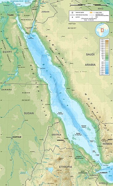
English: Topographic map in English of the Red Sea, UTM projection (WGS84 datum).
Note : for translation purpose, use the SVG version. Français : Carte topographique en anglais de la Mer Rouge, projection UTM (WGS84 datum).
|
||
| 日期 | |||
| 来源 | Own work (see complete description on Image:Red_Sea_topographic_map-en.svg) | ||
| 作者 | Eric Gaba (Sting - fr:Sting) | ||
| 授权 (二次使用本文件) |
|
||
| 其他版本 |
[]
|


许可协议
我,本作品著作权人,特此采用以下许可协议发表本作品:

|
已授权您依据自由软件基金会发行的无固定段落及封面封底文字(Invariant Sections, Front-Cover Texts, and Back-Cover Texts)的GNU自由文件许可协议1.2版或任意后续版本的条款,复制、传播和/或修改本文件。该协议的副本请见“GNU Free Documentation License”。 |
This file is licensed under the Creative Commons Attribution-Share Alike 4.0 International, 3.0 Unported, 2.5 Generic, 2.0 Generic and 1.0 Generic license.
- 您可以自由地:
- 共享 – 复制、发行并传播本作品
- 修改 – 改编作品
- 惟须遵守下列条件:
- 署名 – 您必须对作品进行署名,提供授权条款的链接,并说明是否对原始内容进行了更改。您可以用任何合理的方式来署名,但不得以任何方式表明许可人认可您或您的使用。
- 相同方式共享 – 如果您再混合、转换或者基于本作品进行创作,您必须以与原先许可协议相同或相兼容的许可协议分发您贡献的作品。
您可以选择您需要的许可协议。
文件历史
点击某个日期/时间查看对应时刻的文件。
| 日期/时间 | 缩略图 | 大小 | 用户 | 备注 | |
|---|---|---|---|---|---|
| 当前 | 2023年12月29日 (五) 15:40 | | 1,655 × 2,705(1.63 MB) | Sting | Without frame |
| 2010年7月19日 (一) 13:37 |  | 1,655 × 2,705(1.68 MB) | Sting | Color profile | |
| 2008年9月2日 (二) 04:47 |  | 1,655 × 2,705(1.6 MB) | Sting | New standard colors ; bathymetry from ETOPO1 ; etc. | |
| 2008年4月3日 (四) 19:35 |  | 1,655 × 2,705(1.67 MB) | Sting | Additional corrections | |
| 2008年4月3日 (四) 13:09 |  | 1,655 × 2,705(1.71 MB) | Sting | Some names corrections ; some improvements | |
| 2008年4月3日 (四) 11:26 |  | 1,655 × 2,705(1.67 MB) | Sting | Little correction | |
| 2008年4月2日 (三) 22:32 |  | 1,655 × 2,705(1.7 MB) | Sting | {{Location|21|00|00|N|38|00|00|E|scale:10000000}} <br/> {{Information |Description={{en|Topographic map in English of the red Sea<br/>''Note :'' for translation purpose, use the SVG version.}} {{fr |
文件用途
全域文件用途
以下其他wiki使用此文件:
- ami.wikipedia.org上的用途
- am.wikipedia.org上的用途
- ban.wikipedia.org上的用途
- bg.wikipedia.org上的用途
- bh.wikipedia.org上的用途
- bn.wikipedia.org上的用途
- ca.wikipedia.org上的用途
- ckb.wikipedia.org上的用途
- en.wikipedia.org上的用途
- eu.wikipedia.org上的用途
- fa.wikipedia.org上的用途
- fa.wikivoyage.org上的用途
- gu.wikipedia.org上的用途
- hak.wikipedia.org上的用途
- he.wikipedia.org上的用途
- he.wiktionary.org上的用途
- hi.wikipedia.org上的用途
- hr.wikipedia.org上的用途
- ilo.wikipedia.org上的用途
- incubator.wikimedia.org上的用途
- ja.wikipedia.org上的用途
- ja.wikibooks.org上的用途
- ka.wikipedia.org上的用途
- kcg.wikipedia.org上的用途
- kn.wikipedia.org上的用途
- ko.wikipedia.org上的用途
- lfn.wikipedia.org上的用途
- lv.wikipedia.org上的用途
- mai.wikipedia.org上的用途
- ml.wikipedia.org上的用途
- ms.wikipedia.org上的用途
- my.wikipedia.org上的用途
- ne.wikipedia.org上的用途
- no.wikipedia.org上的用途
- olo.wikipedia.org上的用途
查看本文件的更多全域用途。