File:Roman Empire 125 political map.png

本预览的尺寸:721 × 599像素。 其他分辨率:289 × 240像素 | 578 × 480像素 | 924 × 768像素 | 1,232 × 1,024像素 | 2,186 × 1,817像素。
原始文件 (2,186 × 1,817像素,文件大小:3.21 MB,MIME类型:image/png)
| 相机位置 | | 在以下服务上查看本图像和附近其他图像: OpenStreetMap |
|---|
摘要
| 描述 |
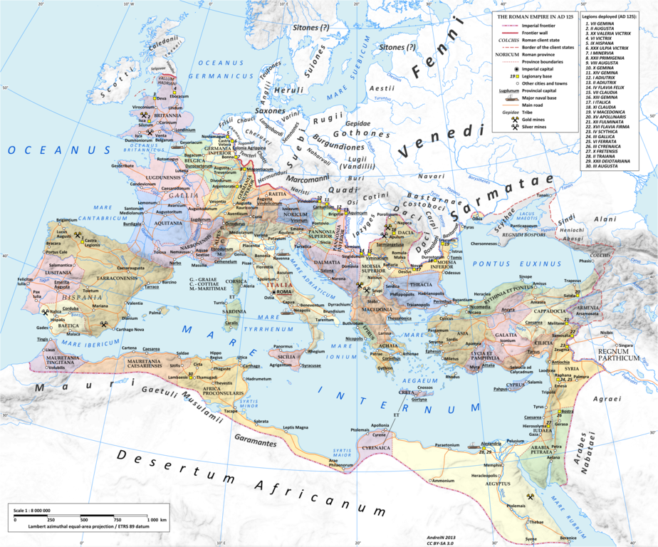
English: Map of the Roman Empire in 125 during the reign of emperor Hadrian.
Projection Lambert azimuthal-equal area. Central latitude: 45° N, central longitude: 20° E. X, Y origin offset - 0 Datum: ETRS89 Sources The physical map was made using the following public domain sources:
Additional references for the map content:
Software used GIS:
Graphics editors:
|
|||
| 日期 | ||||
| 来源 | 自己的作品 | |||
| 作者 | User:Andrein, with the assistance of EraNavigator | |||
| 授权 (二次使用本文件) |
Any use of this map can be made as long as you credit me (Andrei N. – Wikimedia Commons user: Andrein) as the author and distribute the copies and derivative works under the same license as that the one stated below. | |||
| 其他版本 |
[]
|


许可协议
我,本作品著作权人,特此采用以下许可协议发表本作品:
本文件采用知识共享署名-相同方式共享 3.0 未本地化版本许可协议授权。
- 您可以自由地:
- 共享 – 复制、发行并传播本作品
- 修改 – 改编作品
- 惟须遵守下列条件:
- 署名 – 您必须对作品进行署名,提供授权条款的链接,并说明是否对原始内容进行了更改。您可以用任何合理的方式来署名,但不得以任何方式表明许可人认可您或您的使用。
- 相同方式共享 – 如果您再混合、转换或者基于本作品进行创作,您必须以与原先许可协议相同或相兼容的许可协议分发您贡献的作品。

|
已授权您依据自由软件基金会发行的无固定段落及封面封底文字(Invariant Sections, Front-Cover Texts, and Back-Cover Texts)的GNU自由文件许可协议1.2版或任意后续版本的条款,复制、传播和/或修改本文件。该协议的副本请见“GNU Free Documentation License”。 |
您可以选择您需要的许可协议。
_en.png)
.png)
.jpg)
文件历史
点击某个日期/时间查看对应时刻的文件。
| 日期/时间 | 缩略图 | 大小 | 用户 | 备注 | |
|---|---|---|---|---|---|
| 当前 | 2015年7月20日 (一) 18:14 | | 2,186 × 1,817(3.21 MB) | ArdadN | 1 |
| 2015年7月20日 (一) 17:49 |  | 2,186 × 1,817(3.21 MB) | ArdadN | 1 | |
| 2015年3月3日 (二) 18:46 |  | 2,186 × 1,817(3.21 MB) | ArdadN | fixing text problems | |
| 2015年3月3日 (二) 17:05 |  | 2,186 × 1,817(3.18 MB) | ArdadN | new road added | |
| 2015年2月10日 (二) 13:50 |  | 2,186 × 1,817(3.21 MB) | ArdadN | 1 | |
| 2014年5月20日 (二) 18:44 |  | 2,186 × 1,817(3.2 MB) | ArdadN | 1 | |
| 2014年4月9日 (三) 18:19 |  | 2,186 × 1,817(3.2 MB) | ArdadN | Scotti | |
| 2014年4月4日 (五) 19:26 |  | 2,186 × 1,817(3.2 MB) | ArdadN | 1 | |
| 2014年3月30日 (日) 11:47 |  | 2,186 × 1,817(3.19 MB) | ArdadN | removed Scotti, other minor edits | |
| 2013年5月12日 (日) 14:27 |  | 2,186 × 1,817(3.21 MB) | ArdadN | 1 |
文件用途
没有页面链接到本图像。
全域文件用途
以下其他wiki使用此文件:
- af.wikipedia.org上的用途
- bn.wikipedia.org上的用途
- en.wikipedia.org上的用途
- et.wikipedia.org上的用途
- gl.wikipedia.org上的用途
- hu.wikipedia.org上的用途
- id.wikipedia.org上的用途
- it.wikipedia.org上的用途
- ko.wikipedia.org上的用途
- mk.wikipedia.org上的用途
- mr.wikipedia.org上的用途
- ms.wikipedia.org上的用途
- pt.wikipedia.org上的用途