File:Roman expansion 264 BC Shepherd.jpg

本预览的尺寸:762 × 600像素。 其他分辨率:305 × 240像素 | 610 × 480像素 | 976 × 768像素 | 1,280 × 1,008像素 | 2,302 × 1,812像素。
原始文件 (2,302 × 1,812像素,文件大小:873 KB,MIME类型:image/jpeg)
This image was copied from wikipedia:de. The original description was:
| 描述 |
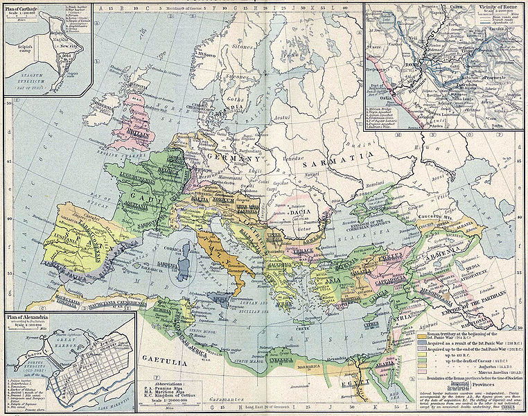
English: Roman territory, from the beginning of the 1st punic war (264 B.C.) to the death of Diocletian
Deutsch: Römisches Reich vom Beginn des 1. Punischen Kriegs (264 v.Chr.) bis zum Tod von Diokletian (312) im Historischen Atlas von William R. Shepherd (1923) |
| 日期 | 1923 |
| 来源 | "Historical Atlas" by William R. Shepherd, New York, Henry Holt and Company |
| 作者 | William R. Shepherd |
| 其他版本 |
|
本作品在其来源国以及其他著作权期限是作者逝世后70年或以下的国家和地区属于公有领域。
| |
| 本文件已被确认为免除已知的著作权法限制(包括所有相关权利)。 | |
| date/time | username | edit summary |
|---|---|---|
| 18:08, 21. Feb 2005 | Benowar | ("Historical Atlas" by William R. Shepherd, New York, Henry Holt and Company, 1923 PUBLIC DOMAIN) |
文件历史
点击某个日期/时间查看对应时刻的文件。
| 日期/时间 | 缩略图 | 大小 | 用户 | 备注 | |
|---|---|---|---|---|---|
| 当前 | 2006年4月18日 (二) 17:08 | | 2,302 × 1,812(873 KB) | Crux | verbesserte Version |
| 2006年4月18日 (二) 16:53 |  | 2,302 × 1,812(767 KB) | Crux | This image was copied from wikipedia:de. The original description was: {{Information| |Description=Roman territory at the beginning of the 1st punic war (264 B.C.) |Source="Historical Atlas" by William R. Shepherd, New York, Henry Holt and Company |Date= |
文件用途
以下2个页面使用本文件:
全域文件用途
以下其他wiki使用此文件:
- ast.wikipedia.org上的用途
- ba.wikipedia.org上的用途
- bn.wikipedia.org上的用途
- br.wikipedia.org上的用途
- ca.wikipedia.org上的用途
- de.wikipedia.org上的用途
- de.wikibooks.org上的用途
- en.wikipedia.org上的用途
- es.wikipedia.org上的用途
- fr.wikipedia.org上的用途
- fy.wikipedia.org上的用途
- it.wikipedia.org上的用途
- it.wikibooks.org上的用途
- lv.wikipedia.org上的用途
- mk.wikipedia.org上的用途
- mwl.wikipedia.org上的用途
- pnb.wikipedia.org上的用途
- pt.wikipedia.org上的用途
- ru.wikipedia.org上的用途
- sa.wikipedia.org上的用途
- skr.wikipedia.org上的用途
- sk.wikipedia.org上的用途
- sl.wikipedia.org上的用途
- sq.wikipedia.org上的用途
- ur.wikipedia.org上的用途
- vi.wikipedia.org上的用途